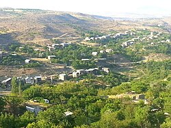
Kanakeravan
Place in Kotayk Country, Armenia From Wikipedia, the free encyclopedia
Place in Kotayk Country, Armenia From Wikipedia, the free encyclopedia
Kanakeravan
Քանաքեռավան | |
|---|---|
 Kanakeravan | |
| Coordinates: 40°14′50″N 44°32′12″E | |
| Country | Armenia |
| մարզ (Marz) (Province) | Kotayk Country |
| Elevation | 1,250 m (4,100 ft) |
| Population (2008) | |
| • Total | 3,204 |
| Time zone | UTC+4 |
Kanakeravan (Armenian, Քանաքեռավան), a village in the Kotayk marz of Armenia, 42 km southwest of the marz center, on the high right bank of the Hrazdan River, blocking KERG.
Seamless Wikipedia browsing. On steroids.
Every time you click a link to Wikipedia, Wiktionary or Wikiquote in your browser's search results, it will show the modern Wikiwand interface.
Wikiwand extension is a five stars, simple, with minimum permission required to keep your browsing private, safe and transparent.