Kalkini Upazila
Upazila in Dhaka, Bangladesh From Wikipedia, the free encyclopedia
Upazila in Dhaka, Bangladesh From Wikipedia, the free encyclopedia
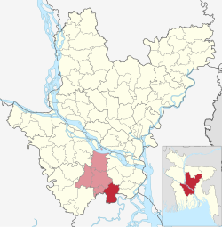
Kalkini (Bengali: কালকিনি) is an upazila of Madaripur District in the Division of Dhaka, Bangladesh.[4]
Kalkini
কালকিনি | |
|---|---|
 Kalkini Pourashava building | |
 | |
| Coordinates: 23°4′N 90°14.5′E | |
| Country | |
| Division | Dhaka |
| District | Madaripur |
| Parliamentary Constituency | Madaripur-3 |
| Area | |
| • Upazila | 204.28 km2 (78.87 sq mi) |
| • Metro | 27 km2 (10 sq mi) |
| Population | |
| • Upazila | 218,330 |
| • Density | 1,100/km2 (2,800/sq mi) |
| • Metro | 48,865 |
| • Metro density | 1,800/km2 (4,700/sq mi) |
| Time zone | UTC+6 (BST) |
| Postal Code | 7920[2] |
| Area code | 06622[3] |
| Website | http://kalkini.madaripur.gov.bd |
Kalkini Police Station was established in 1909 and it was turned into an upazila on 1 February 1984.[4] Kalkini Municipality was established in 1997. The Dasar Police Station was declared on March 2, 2013, with a partial area of Kalkini Police Station. Earlier, the Dasar Union was divided into two units, Betwari and Dasar, and the Nabagram Union divided into two other unions, named Sasikar and Nabagram. A police inquiry center was established at Dasar on February 2, 2012, with a total of six unions, including Gopalpur and Kazibakai unions.[5]
Kalkini is located in between 23°00' and 23°10' North latitudes and in between 90°06' and 90°21' East longitudes.[4] It has total area 204.28 km2. It is bounded by Madaripur Sadar Upazila on the north, Gaurnadi Upazila on the south, Gosairhat Upazila on the east, Kotalipara Upazila on the west.[6]
According to the 2011 Census of Bangladesh, residual Kalkini Upazila had 43,716 households and a population of 201,764. 51,505 (25.53%) were under 10 years of age. Kalkini had a literacy rate (age 7 and over) of 47.23%, compared to the national average of 51.8%, and a sex ratio of 1065 females per 1000 males. 41,608 (20.62%) lived in urban areas.[8][9]
Kalkini Upazila is divided into Kalkini Municipality and 9 union parishads: Alinagar, Banshgari, Char Daulatkhan, Enayet Nagar, Kayaria, Lakshmipur, Ramjanpur, Sahebrampur, and Shikar Mangol. The union parishads are subdivided into 160 mauzas and 171 villages.[9]
Kalkini Municipality is subdivided into 9 wards and 38 mahallas.[9]
Kalkini has an average literacy rate of 47%; Male constitutes 50% and Female 46.2%.
Seamless Wikipedia browsing. On steroids.
Every time you click a link to Wikipedia, Wiktionary or Wikiquote in your browser's search results, it will show the modern Wikiwand interface.
Wikiwand extension is a five stars, simple, with minimum permission required to keep your browsing private, safe and transparent.