Top Qs
Timeline
Chat
Perspective
Jesenské, Rimavská Sobota District
Municipality in Banská Bystrica Region, Slovakia From Wikipedia, the free encyclopedia
Remove ads
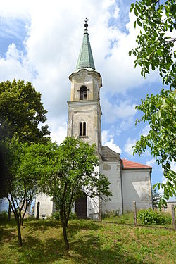
Jesenské (formerly: Feledince; Hungarian: Feled) is a village and municipality in the Rimavská Sobota District of the Banská Bystrica Region of southern Slovakia.[4]
Remove ads
Remove ads
History
The first mention is from 1274. In 1424, the village is noticed as property of the Feledys. As early as the Middle Ages, the village was important agricultural centre of the region. In 1553 was the village pillaged. From 1938 to 1945, it belonged to Hungary. Jesenské had been in 20th century seat of the Jesenské District.
Economy and infrastructure
Municipal office had been built in 1936. The village is important railway crossroad, as the Bratislava-Košice line crosses with a Jesenské-Tisovec line. In 2012 small reconstruction of the village center began.[5] In 1922 a football club was established, which is one of the best sport clubs in the village.[6]
See also
References
Genealogical resources
External links
Wikiwand - on
Seamless Wikipedia browsing. On steroids.
Remove ads


