Jabonga

Municipality in Agusan del Norte, Philippines From Wikipedia, the free encyclopedia

Jabongamap

Jabonga, officially the Municipality of Jabonga (Cebuano: Lungsod sa Jabonga; Tagalog: Bayan ng Jabonga), is a municipality in the province of Agusan del Norte, Philippines. According to the 2020 census, it has a population of 24,855 people.[3]

Quick Facts Country, Region ...
Jabonga
Municipality of Jabonga
Thumb
Thumb
Thumb
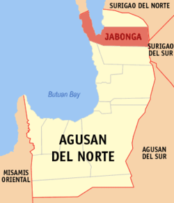
Map of Agusan del Norte with Jabonga highlighted
OpenStreetMap
Thumb
Thumb
Jabonga
Location within the Philippines
Coordinates: 9°20′35″N 125°30′56″E
CountryPhilippines
RegionCaraga
ProvinceAgusan del Norte
District 2nd district
Barangays15 (see Barangays)
Government
[1]
  TypeSangguniang Bayan
  MayorNapoleon M. Montero
  Vice MayorDanny M. Moran
  RepresentativeMa. Angelica Amante-Matba
  Municipal Council
Members
  Electorate17,083 voters (2022)
Area
  Total
293 km2 (113 sq mi)
Elevation
114 m (374 ft)
Highest elevation
627 m (2,057 ft)
Lowest elevation
0 m (0 ft)
Population
 (2020 census)[3]
  Total
24,855
  Density85/km2 (220/sq mi)
  Households
6,207
Economy
  Income class3rd municipal income class
  Poverty incidence
38.15
% (2021)[4]
  Revenue138.6 million (2020)
  Assets287.2 million (2020)
  Expenditure116.4 million (2020)
  Liabilities160.3 million (2020)
Service provider
  ElectricityAgusan del Norte Electric Cooperative (ANECO)
Time zoneUTC+8 (PST)
ZIP code
8607
PSGC
IDD:area code+63(0)85
Native languagesSurigaonon
Butuanon
Cebuano
Higaonon
Mamanwa
Tagalog
Websitewww.jabongaadn.gov.ph
Close

Geography

Summarize
Perspective

According to the Philippine Statistics Authority, the municipality has a land area of 293 square kilometres (113 sq mi)[5] constituting 10.73% of the 2,730.24-square-kilometre- (1,054.15 sq mi) total area of Agusan del Norte.

Jabonga is bounded by Kitcharao and Surigao del Norte to the north; Butuan Bay to the west; Tubay and Santiago to the south; Surigao del Sur to the east. It is 60 kilometres (37 mi) from Butuan City.

The topography of the land features plain to rolling and hills. Among the municipalities, Jabonga ranks first in total area and number of farms (464) mostly owned by individuals. It has one of the 36 crop storage facilities of the province. Its major crops are coconut, rice, corn, timber and both fresh and sea-water fish.

Climate

More information Climate data for Jabonga, Agusan del Norte, Month ...
Climate data for Jabonga, Agusan del Norte
Month Jan Feb Mar Apr May Jun Jul Aug Sep Oct Nov Dec Year
Mean daily maximum °C (°F) 27
(81)
27
(81)
28
(82)
29
(84)
30
(86)
29
(84)
29
(84)
29
(84)
29
(84)
29
(84)
28
(82)
28
(82)
29
(83)
Mean daily minimum °C (°F) 23
(73)
23
(73)
23
(73)
23
(73)
24
(75)
25
(77)
24
(75)
24
(75)
24
(75)
24
(75)
24
(75)
23
(73)
24
(74)
Average precipitation mm (inches) 210
(8.3)
161
(6.3)
123
(4.8)
85
(3.3)
148
(5.8)
186
(7.3)
164
(6.5)
157
(6.2)
141
(5.6)
190
(7.5)
223
(8.8)
200
(7.9)
1,988
(78.3)
Average rainy days 21.0 16.8 18.5 18.2 24.9 27.7 28.4 27.0 26.1 27.6 24.6 22.0 282.8
Source: Meteoblue[6]
Close

Barangays

Jabonga is politically subdivided into 15 barangays.[7] Each barangay consists of puroks while some have sitios.

Libas farmers cooperative
More information PSGC, Barangay ...
PSGC Barangay Population ±% p.a.
2020[3] 2010[8]
160205003 A. Beltran (Camalig) 4.3% 1,077 1,149 −0.64%
160205001 Baleguian 9.3% 2,301 2,136 0.75%
160205002 Bangonay 13.5% 3,361 3,073 0.90%
160205004 Bunga 3.4% 842 951 −1.21%
160205005 Colorado 7.5% 1,858 1,570 1.70%
160205006 Cuyago 7.8% 1,949 2,015 −0.33%
160205007 Libas 5.8% 1,437 1,455 −0.12%
160205008 Magdagooc 6.4% 1,585 1,464 0.80%
160205009 Magsaysay 4.5% 1,117 1,155 −0.33%
160205010 Maraiging 2.1% 526 507 0.37%
160205011 Poblacion (Jabonga) 16.1% 4,004 3,713 0.76%
160205012 San Jose 3.7% 921 977 −0.59%
160205013 San Pablo 5.2% 1,299 957 3.10%
160205014 San Vicente 6.5% 1,611 1,747 −0.81%
160205015 Santo Niño 3.9% 967 964 0.03%
Total 24,855 23,833 0.42%
Close

Demographics

More information Year, Pop. ...
Population census of Jabonga
YearPop.±% p.a.
1903 1,450    
1918 2,545+3.82%
1939 5,004+3.27%
1948 7,700+4.91%
1960 14,721+5.55%
1970 12,129−1.92%
1975 14,742+3.99%
1980 15,912+1.54%
1990 18,610+1.58%
1995 20,196+1.54%
2000 20,501+0.32%
2007 23,052+1.63%
2010 23,833+1.22%
2015 23,184−0.52%
2020 24,855+1.38%
Source: Philippine Statistics Authority[9][8][10][11]
Close

In the 2020 census, Jabonga had a population of 24,855.[3] The population density was 85 inhabitants per square kilometre (220/sq mi).

Economy

Poverty incidence of Jabonga

10
20
30
40
50
2006
48.60
2009
45.69
2012
48.10
2015
42.33
2018
31.30
2021
38.15

Source: Philippine Statistics Authority[12][13][14][15][16][17][18][19]

Thumb
24.9-megawatt Lake Mainit Hydroelectric Power Plant in Barangay Magdagooc, Jabonga, Agusan del Norte

Jabonga is home of the 24.9 mW Lake Mainit Hydro Power Plant that will serves Agusan del Norte.[20] [21]

Culture

Festivals and celebrations

  • Sumayajaw Festival- Held during the town fiesta of Jabonga. It is a thanksgiving celebration for the bounties showered by the Heavenly Father through the intercession of the Blessed Virgin Mary, the Lady of Assumption.
  • Baoto Festival- Held annually, this is a regional race for native wooden barotos, the main event is the 30K Paddling Marathon. Other activities include tree planting, adventure skills clinic, triathlon, airsoft match and bikini open.

Transportation

By land

Jabonga is accessible by bus from Bachelor Express, Davao Metro Shuttle, or Surigao Bus via Butuan-Surigao routes or vice versa. There are also vans, jeep and multi-cabs that have routes towards both Surigao City and Butuan which are stationed in Jabonga Integrated Land Transport Terminal.

By air and sea

Not Accessible

References

Wikiwand - on

Seamless Wikipedia browsing. On steroids.