Loading AI tools
Mountain in Morocco. From Wikipedia, the free encyclopedia
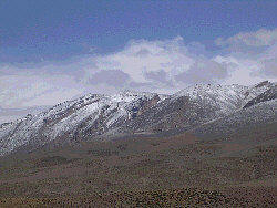
The M'Goun mountain, also rendered as Ighil Mgoun / Ighil M’Goun / Irhil M’Goun (in tifinagh ⵉⵖⵉⵍ ⵎⴳⵯⵏ), Ighil n’Oumsoud, Jebel Mgoun, Jebel Ighil M’Goun and Jebel Aït M’goun, at 4,071 metres (13,356 ft) is the third highest peak of the Atlas Mountains after Toubkal and Ouenkrim.
| M'Goun جبال مكون, ⵉⵖⵉⵍ ⵎⴳⵯⵓⵏ | |
|---|---|
 Ighil M'Goun | |
| Highest point | |
| Elevation | 4,071 m (13,356 ft)[1] |
| Prominence | 1,904 m (6,247 ft)[1] |
| Listing | List of Ultras of Africa |
| Coordinates | 31°30′30″N 6°26′36″W[1] |
| Geography | |
| Location | Drâa-Tafilalet, Morocco |
| Parent range | High Atlas Range |
It is an ultra prominent peak located in the Drâa-Tafilalet region of Morocco.
An area of 5,370 km2 in the region was designated as a UNESCO Global Geopark in 2015, having become a member of the Global Geopark Network the previous year. The Geopark showcases tectonic structures within the Atlas Mountains as well as aspects of the area's cultural history.[2]


Seamless Wikipedia browsing. On steroids.
Every time you click a link to Wikipedia, Wiktionary or Wikiquote in your browser's search results, it will show the modern Wikiwand interface.
Wikiwand extension is a five stars, simple, with minimum permission required to keep your browsing private, safe and transparent.