Loading AI tools
Town in Sigmaringen, Germany From Wikipedia, the free encyclopedia
Veringenstadt (Swabian: Verenga) is a town in the district of Sigmaringen, in Baden-Württemberg, Germany. It is situated 10 km north of Sigmaringen.

You can help expand this article with text translated from the corresponding article in German. (February 2009) Click [show] for important translation instructions.
|
Veringenstadt | |
|---|---|
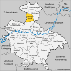
Location of Veringenstadt within Sigmaringen district  | |
| Coordinates: 48°10′42″N 9°12′43″E | |
| Country | Germany |
| State | Baden-Württemberg |
| Admin. region | Tübingen |
| District | Sigmaringen |
| Government | |
| • Mayor (2022–30) | Maik Rautenberg[1] |
| Area | |
| • Total | 31.24 km2 (12.06 sq mi) |
| Elevation | 631 m (2,070 ft) |
| Population (2022-12-31)[2] | |
| • Total | 2,146 |
| • Density | 69/km2 (180/sq mi) |
| Time zone | UTC+01:00 (CET) |
| • Summer (DST) | UTC+02:00 (CEST) |
| Postal codes | 72519 |
| Dialling codes | 07577 |
| Vehicle registration | SIG |
| Website | www |
Veringenstadt is situated in the valley of the Lauchert, a tributary of the Danube, between Gammertingen and Sigmaringen. The municipality area is 3125 hectares.[3]
The municipality Veringenstadt lies on the Lauchertgraben (Lauchert trench). East of Veringendorf a petrified sponge reef can be seen, which was created 140 million years ago.[4]
The area of the present municipality Veringenstadt was already settled in early historical times. The town itself is an ancient settlement which was already mentioned in a document around the year 786. It derives its name from a certain "Fara" or "Faro", was so well earlier "Faringa", about 1130 Veringin, later always Veringen.[5] The counts of Veringen were one of the wealthiest and most respected dynasties of the 11th and 12th century in southern Germany.[6][7] Through targeted resettlement of population from the surrounding hamlets succeeded about 1250 the foundation of the city of Veringen (today Veringenstadt). After the Thirty Years' War (1618–1648) about 1650 farmers from Tirol were recruited for Veringenstadt and settled here.[8] From 1827 to 1925 Veringenstadt belonged to Oberamt Gammertingen. 1850 it became as part of the principality Hohenzollern-Sigmaringen prussian, and belonged to the province of Hohenzollern. Ore was mined in the 18th and 19th century.[4] Since 1927 the municipality belongs to the district of Sigmaringen. Since 1945, the city belonged to Württemberg-Hohenzollern, which opened in Baden-Württemberg in 1952. By the inclusion of expellees after 1945, the population of Veringenstadt has nearly doubled in the 1950s.[8] On February 1, 1972 Hermentingen was incorporated. The incorporation of Veringendorf was on January 1, 1975.
The municipality combines the main locality Veringenstadt with the two villages Hermentingen and Veringendorf.

The emblem of Veringenstadt was officially approved 1947. Already 1320 a lion and a deer rod was used as coat of arms. The coat of arms shows a golden shield a red lion under a layer of a red deer rack. The lion comes from the Habsburg coat of arms, the deer bar is derived from the coat of arms of the Counts of Veringen.
Veringenstadt maintains since 2012 a partnership with the city of Zwettl an der Rodl in Austria.
Veringenstadt is dominated by a medieval core with half-timbered houses, the castle Veringen and religious buildings:


Electrical works (Brothers Haux 1902) in Veringendorf[10]
In Veringenstadt are more than 30 clubs. With currently 450 members, the TSV is the largest. (as of 15 January 2011).[3]
The municipalities Veringenstadt and Veringendorf were connected to the rail network by the Kleinengstingen-Sigmaringen railway. The Göpfelstein was tunneled at Veringenstadt. The 91-meter long tunnel was built by Italian workers. The first train passed through the tunnel Veringen at Christmas, 1907, the line was opened in 1908.[12][13] The Federal Highway 32 led originally through the Veringenstadt center. Between 1975 and 1980, a road tunnel was built. Today daily drive around 5000 vehicles through the Schlossberg tunnel. The Public transport is guaranteed by the Verkehrsverbund Neckar-Alb-Donau (NALDO). The community is located in the comb 442.
The Schwörer Haus maintains in Veringenstadt a factory making fort massif houses, ceilings, precast concrete, chimneys.
There are two schools in the nucleus. A primary school and since the school year 2010/2011 a branch of the Werkrealschule Gammertingen.[3] The school building of the Alb-Lauchert School in Veringenstadt, an elementary school, was built in 1953. In Veringenstadt there is a day care center with full-day care, in Veringendorf a kindergarten, which also accommodates children under three years.[3]

{{citation}}: CS1 maint: location missing publisher (link)Seamless Wikipedia browsing. On steroids.
Every time you click a link to Wikipedia, Wiktionary or Wikiquote in your browser's search results, it will show the modern Wikiwand interface.
Wikiwand extension is a five stars, simple, with minimum permission required to keep your browsing private, safe and transparent.