Gowganda
Dispersed Rural Community in Ontario, Canada From Wikipedia, the free encyclopedia
Dispersed Rural Community in Ontario, Canada From Wikipedia, the free encyclopedia
Gowganda is a Dispersed Rural Community and unincorporated place in geographic Nicol Township,[3] Timiskaming District, in northeastern Ontario, Canada.[1] It is at the outlet of the Montreal River from Lake Gowganda, and is on Ontario Highway 560.

Gowganda | |
|---|---|
Dispersed Rural Community | |
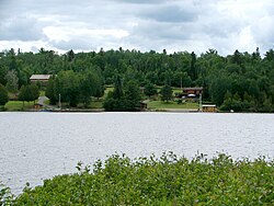
 Lookout Point Lodge, seen from Gowganda Lake at Gowganda | |
| Coordinates: 47°38′57″N 80°46′13″W[1] | |
| Country | Canada |
| Province | Ontario |
| District | Timiskaming |
| Census subdivision | Unorganized West Timiskaming District |
| Elevation | 356 m (1,168 ft) |
| Time zone | UTC-5 (Eastern Time Zone) |
| • Summer (DST) | UTC-4 (Eastern Time Zone) |
| Postal Code | P0J 1J0 |
| Area codes | 705, 249 |
Seamless Wikipedia browsing. On steroids.
Every time you click a link to Wikipedia, Wiktionary or Wikiquote in your browser's search results, it will show the modern Wikiwand interface.
Wikiwand extension is a five stars, simple, with minimum permission required to keep your browsing private, safe and transparent.