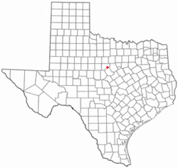
Gorman is a city in Eastland County, Texas, United States. Its population was 976 at the 2020 census,[3] down from 1,083 at the 2010 census.[5]
Gorman, Texas | |
|---|---|
 Location of Gorman, Texas | |
 | |
| Coordinates: 32°12′49″N 98°40′19″W | |
| Country | United States |
| State | Texas |
| County | Eastland |
| Area | |
| • Total | 1.64 sq mi (4.26 km2) |
| • Land | 1.64 sq mi (4.26 km2) |
| • Water | 0.00 sq mi (0.00 km2) |
| Elevation | 1,450 ft (440 m) |
| Population | |
| • Total | 976 |
| • Density | 629.95/sq mi (243.19/km2) |
| Time zone | UTC-6 (Central (CST)) |
| • Summer (DST) | UTC-5 (CDT) |
| ZIP code | 76454 |
| Area code | 254 |
| FIPS code | 48-30308[4] |
| GNIS feature ID | 2410625[2] |
| Website | www |
Geography
Gorman is located in southeastern Eastland County. Texas State Highway 6 passes through the community, leading northwest 20 miles (32 km) to Eastland, the county seat, and southeast 11 miles (18 km) to De Leon.
According to the United States Census Bureau, the city has a total area of 1.7 square miles (4.3 km2), all land.[1]
Climate
The climate in this area is characterized by hot, humid summers and generally mild to cool winters. According to the Köppen climate classification, Gorman has a humid subtropical climate, Cfa on climate maps.[6]
Demographics
2020 census
| Race | Number | Percentage |
|---|---|---|
| White (NH) | 564 | 57.79% |
| Black or African American (NH) | 4 | 0.41% |
| Native American or Alaska Native (NH) | 2 | 0.2% |
| Asian (NH) | 1 | 0.1% |
| Pacific Islander (NH) | 4 | 0.41% |
| Mixed/Multi-Racial (NH) | 27 | 2.77% |
| Hispanic or Latino | 374 | 38.32% |
| Total | 976 |
As of the 2020 United States census, there were 976 people, 501 households, and 331 families residing in the city.
2000 census
As of the census[4] of 2000, 1,236 people, 474 households, and 310 families were residing in the city. The population density was 750.7 inhabitants per square mile (289.8/km2). The 569 housing units averaged 345.6/sq mi (133.1/km2). The racial makeup of the city was 80.42% White, 0.08% African American, 0.89% Native American, 17.72% from other races, and 0.89% from two or more races. Hispanics or Latinos of any race were 29.13% of the population.
Of the 474 households, 33.1% had children under 18 living with them, 51.1% were married couples living together, 9.7% had a female householder with no husband present, and 34.4% were not families. About 32.7% of all households were made up of individuals, and 21.1% had someone living alone who was 65 or older. The average household size was 2.53, and the average family size was 3.24.
In the city, the age distribution was 28.2% under 18, 8.4% from 18 to 24, 24.1% from 25 to 44, 18.4% from 45 to 64, and 20.8% who were 65 years of age or older. The median age was 38 years. For every 100 females, there were 85.9 males. For every 100 females age 18 and over, there were 79.9 males.
The median income for a household in the city was $26,758, and for a family was $32,431. Males had a median income of $25,800 versus $18,417 for females. The per capita income for the city was $11,906. 16.3% of the population and 10.1% of families were below the poverty line. Out of the total population, 20.4% of those under the age of 18 and 19.6% of those 65 and older were living below the poverty line.
Education
The city is served by the Gorman Independent School District.
Notable person
- Joe Isbell, NFL offensive guard
References
External links
Wikiwand in your browser!
Seamless Wikipedia browsing. On steroids.
Every time you click a link to Wikipedia, Wiktionary or Wikiquote in your browser's search results, it will show the modern Wikiwand interface.
Wikiwand extension is a five stars, simple, with minimum permission required to keep your browsing private, safe and transparent.