Fenoarivo Atsinanana
Place in Analanjirofo, Madagascar From Wikipedia, the free encyclopedia

Fenoarivo Atsinanana (French: Fénérive Est) is a city (commune urbaine) in Madagascar.
Fenoarivo Atsinanana
Fénérive Est | |
|---|---|
 Memorial plaque on Independence avenue | |
 Coat of arms | |
 Fenoarivo Atsinanana Location in Madagascar | |
| Coordinates: 17°22′53″S 49°24′33″E | |
| Country | |
| Region | Analanjirofo |
| Area | |
| • Total | 22.9 km2 (8.8 sq mi) |
| Population (2018 census) | |
| • Total | 41,734 |
| • Density | 1,800/km2 (4,700/sq mi) |
| Postal code | 509 |
| Climate | Af |
It is the capital of the Analanjirofo region and of the district of Fenerive-Est.
Geography
It is situated at the East coast of Madagascar, about 103 km north of the city of Toamasina and 58 kms south of Soanierana-Ivongo along the National road 5 to Maroantsetra.
Economy
The region around Fenoarivo is one of the most important clove growing areas of Madagascar. The city is also one of the most important sea resorts at the East coast.
History
In the 17th century it was a privateer's harbour. Ratsimilaho, the first king of the Betsimisaraka, was the son of a pirate and a local princess. He is buried on the island Nosy Hely, a former pirate's stronghold that can be visited today (Vohimasina).[1]
Religion
- FJKM - Fiangonan'i Jesoa Kristy eto Madagasikara (Church of Jesus Christ in Madagascar)
- FLM - Fiangonana Loterana Malagasy (Malagasy Lutheran Church)
- Catholic Diocese (Cathedral of St. Maurice).
Museums
The Lampy Museum.
Gallery
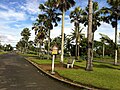 Independence avenue
 Public market
 Post office
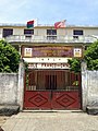 French-Chinese school
 Fishermen


Wikimedia Commons has media related to Fenoarivo Atsinanana.
References
Wikiwand in your browser!
Seamless Wikipedia browsing. On steroids.
Every time you click a link to Wikipedia, Wiktionary or Wikiquote in your browser's search results, it will show the modern Wikiwand interface.
Wikiwand extension is a five stars, simple, with minimum permission required to keep your browsing private, safe and transparent.