Top Qs
Timeline
Chat
Perspective
Ermera Municipality
Municipality of East Timor From Wikipedia, the free encyclopedia
Remove ads
Ermera (Portuguese: Município Ermera, Tetum: Munisípiu Ermera) is one of the municipalities (formerly districts) of Timor-Leste, located in the west-central part of the country. It has a population of 117,064 (Census 2010) and an area of 756.5 km2.
You can help expand this article with text translated from the corresponding article in German. (July 2011) Click [show] for important translation instructions.
|
This article needs additional citations for verification. (December 2009) |
Remove ads
Toponymy
The word Ermera means 'red water' in the local Mambai language.[2] It is said that the ancestors of the municipality's present inhabitants originated from three mountains, namely Cailitlau, Lalimlau, and Hituria, and that the name Ermera refers to the red waters flowing from those mountains.[3]
Geography

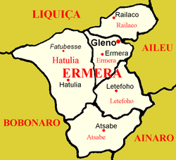
Ermera is one of only two land-locked municipalities in Timor-Leste, the other being Aileu. It borders Liquiçá to the north, Dili to the northeast, Alieu to the east, Ainaro to the southeast, and Bobonaro to the west.
The boundaries of the municipality are identical to those of the district of the same name in Portuguese Timor. Its capital is Gleno, which is located 30 km to the southwest of the national capital, Dili. The city of Ermera, also known as Vila Ermera, lies 58 km from the capital along the same road. In Marobo (Atsabe Administrative Post) are the remains of a hot springs bath from colonial times. The pool is still in use.[4]
 |
 |
Remove ads
Administrative posts
The municipality's administrative posts (formerly sub-districts) are:[5][6]
- Atsabe Administrative Post
- Ermera Administrative Post
- Hatulia Administrative Post
- Hatulia B Administrative Post
- Letefoho Administrative Post
- Railaco Administrative Post
The administrative posts are divided into 52 sucos ("villages") in total.
References
External links
Wikiwand - on
Seamless Wikipedia browsing. On steroids.
Remove ads


