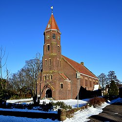
Elim is a village in Drenthe (province of The Netherlands) and is part of the Hoogeveen municipality.
Elim | |
|---|---|
 Church in Elim | |
Location in province of Drenthe in the Netherlands | |
| Coordinates: 52.6799°N 6.5776°E | |
| Country | Netherlands |
| Province | Drenthe |
| Municipality | Hoogeveen |
| Area | |
| • Total | 13.12 km2 (5.07 sq mi) |
| Elevation | 12 m (39 ft) |
| Population (2021)[1] | |
| • Total | 2,335 |
| • Density | 180/km2 (460/sq mi) |
| Time zone | UTC+1 (CET) |
| • Summer (DST) | UTC+2 (CEST) |
| Postal code | 7916[1] |
| Dialing code | 0528 |
History
Before 1786, there were only swamps in this part of the Netherlands. After the drainage of the swamps, people started to harvest peat, which was transported to the west of the Netherlands.[3] The people who harvested the peat built houses on the land and started a small community, on the present place of Elim, called "Het Dwarsgat".[4] In 1915, the village became known as Elim. The name Elim is from the Bible, Exodus 15:27 : "there were twelve wells of water, and seventy date palms," and the Israelites "camped there near the water".[4]
References
External links
Wikiwand in your browser!
Seamless Wikipedia browsing. On steroids.
Every time you click a link to Wikipedia, Wiktionary or Wikiquote in your browser's search results, it will show the modern Wikiwand interface.
Wikiwand extension is a five stars, simple, with minimum permission required to keep your browsing private, safe and transparent.


