Dolní Novosedly
Municipality in South Bohemian, Czech Republic From Wikipedia, the free encyclopedia
Municipality in South Bohemian, Czech Republic From Wikipedia, the free encyclopedia
Dolní Novosedly is a municipality and village in Písek District in the South Bohemian Region of the Czech Republic. It has about 300 inhabitants.
Dolní Novosedly | |
|---|---|
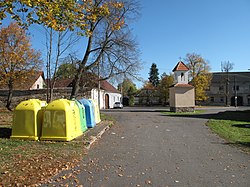
 Centre of Dolní Novosedly | |
| Coordinates: 49°19′45″N 14°11′46″E | |
| Country | |
| Region | South Bohemian |
| District | Písek |
| First mentioned | 1517 |
| Area | |
| • Total | 5.48 km2 (2.12 sq mi) |
| Elevation | 486 m (1,594 ft) |
| Population (2024-01-01)[1] | |
| • Total | 260 |
| • Density | 47/km2 (120/sq mi) |
| Time zone | UTC+1 (CET) |
| • Summer (DST) | UTC+2 (CEST) |
| Postal code | 397 01 |
| Website | www |
The villages of Chrastiny and Horní Novosedly are administrative parts of Dolní Novosedly.
Dolní Novosedly is located about 4 kilometres (2 mi) northeast of Písek and 43 km (27 mi) northwest of České Budějovice. It lies in the Tábor Uplands. The highest point is the hill Mláka at 548 m (1,798 ft) above sea level. The Podhorák pond is located in the municipality.
The first written mention of Dolní Novosedly is from 1517.[2]
The I/29 road from Písek to Tábor passes through the municipality.
Dolní Novosedly is poor in monuments. In the centre of Dolní Novosedly is a chapel from the 19th century.[5]
Seamless Wikipedia browsing. On steroids.
Every time you click a link to Wikipedia, Wiktionary or Wikiquote in your browser's search results, it will show the modern Wikiwand interface.
Wikiwand extension is a five stars, simple, with minimum permission required to keep your browsing private, safe and transparent.