Darvoz District
District in Gorno-Badakhshan Autonomous Region, Tajikistan From Wikipedia, the free encyclopedia
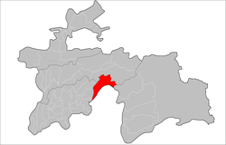
Darvoz District (Russian: Дарвазский район, Tajik: Ноҳияи Дарвоз Nohiyai Darvoz) is a district in Tajikistan, located at the extreme north-west of the Gorno-Badakhshan Autonomous Region. It borders on Afghanistan to the south, along the Panj, and within Tajikistan on Khatlon Region to the west and on the Districts of Republican Subordination to the north.[3] Its administrative capital is Qal'ai Khumb. The population of Darvoz district is 24,000 (1 January 2020 estimate).[1] The district was historically part of the Darvaz principality, a semi-independent statelet ruled by a mir.[4]

 Afghanistan and
  Tajikistan in Region Darwaz-Darvoz, * Qal'ai Khumb, *Nusay.
 Darvoz District
| |
|---|---|
 Location of Darvoz District in Tajikistan | |
| Coordinates: 38°30′N 70°45′E | |
| Country | Tajikistan |
| Region | Gorno-Badakhshan Autonomous Region |
| Capital | Qal'ai Khumb |
| Area | |
• Total | 2,824.5 km2 (1,090.5 sq mi) |
| Elevation | 4,484 m (14,711 ft) |
| Population (2020)[1] | |
• Total | 24,000 |
| • Density | 8.5/km2 (22/sq mi) |
| Time zone | UTC+5 (TJT) |
| Postal code | 736400 |
| Area code | +992 3552 |
| Official languages | |
Administrative divisions
The district has an area of about 2,800 km2 (1,000 sq mi) and is divided administratively into four jamoats.[5] They are as follows:[6]
| Jamoat | Population (Jan. 2015)[6] |
|---|---|
| Nulvand | 4,025 |
| Qal'ai Khumb | 8,366 |
| Saghirdasht | 5,420 |
| Vishkharv | 3,637 |
See also
References
Wikiwand - on
Seamless Wikipedia browsing. On steroids.
