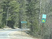
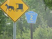
The Franklin County, New York, Highway Department maintains 266 miles (428 km) of roads as county routes. All county routes in Franklin County are signed with a yellow and blue pentagon. Formerly, the county used a green square marker that was unique to the county. There is no apparent pattern to how routes are assigned; however, no active county route has the same number as any of the county's U.S. Highways or New York state touring routes, with the exception of County Route 3 (CR 3). The section of New York State Route 374 (NY 374) that lies north of U.S. Route 11 (US 11) is owned and maintained by Franklin County and is thus co-signed as a state touring route and as a Franklin County route. The longest route in the county is CR 26, which was once NY 99.
  The former and current standard route marker for county routes in Franklin County. | |
| Highway names | |
|---|---|
| Interstates | Interstate X (I-X) |
| US Highways | U.S. Route X (US X) |
| State | New York State Route X (NY X) |
| County: | County Route X (CR X) |
| System links | |
Routes 1–30
| Route | Length (mi)[1] |
Length (km) |
From | Via | To | Notes |
|---|---|---|---|---|---|---|
| 4.72 | 7.60 | NY 95 / CR 4 in Bombay | Bombay–Fort Covington Road | NY 37 in Fort Covington | ||
| 3.21 | 5.17 | NY 95 | Townsend Road in Bombay | CR 1 | ||
| 5.48 | 8.82 | CR 8 in Bangor | Cooks Corners Road | CR 4 in Fort Covington | ||
| 7.80 | 12.55 | NY 95 / CR 1 in Bombay | Coggin Bridge–Bombay Road | NY 37 in Westville | ||
| 10.97 | 17.65 | NY 458 in Waverly | Moira–St. Regis Falls Road | US 11 / NY 95 in Moira | Was part of NY 95 during the 1930s[2] | |
| 3.41 | 5.49 | St. Lawrence County line (becomes CR 52) | North Lawrence–Moira Road in Moira | NY 95 | ||
| 3.89 | 6.26 | NY 11B in Dickinson | Gale Road | US 11 in Brushton | ||
| 10.31 | 16.59 | Brushton village line at Moira | Fay–Brushton Road | NY 37 in Malone | ||
| 1.24 | 2.00 | St. Lawrence County line (becomes CR 37) | Helena Road in Bombay | NY 95 | ||
| 2.98 | 4.80 | CR 12 in Brandon | Crooks Road | NY 11B in Bangor | ||
| 2.30 | 3.70 | US 11 / CR 53 | Depot Road in Bangor | CR 8 | Former number; see CR 22 | |
| 3.63 | 5.84 | CR 15 | Skerry Road in Brandon | CR 13 | ||
| 3.21 | 5.17 | CR 12 in Brandon | Bangor–Skelly Road | NY 11B / CR 53 in Bangor | ||
| 14.85 | 23.90 | CR 5 in Waverly | Red Tavern Road | NY 30 / CR 26 in Duane | ||
| 2.71 | 4.36 | CR 12 in Brandon | Eddy Road | NY 11B in Bangor | ||
| 2.90 | 4.67 | NY 11B | Bacon Road in Bangor | US 11 | ||
| 4.95 | 7.97 | US 11 in Moira | Sayles Road | CR 32 in Bombay | ||
| 8.16 | 13.13 | NY 30 in Santa Clara | Forest Home Road | Ampersand Avenue in Harrietstown | ||
| 5.03 | 8.10 | CR 8 in Bangor | Jewett Road | NY 37 / NY 122 in Westville | ||
| 5.93 | 9.54 | NY 37 in Westville | Trout River–Westville Road | NY 30 in Constable | ||
| 0.23 | 0.37 | CR 19 | Old State Highway in Westville | NY 37 | ||
| 10.26 | 16.51[4] | NY 37 in Westville | Unnamed road | US 11 in Burke | Transferred to state in 1980;[5] now NY 122 | |
| 2.30 | 3.70 | US 11 / CR 53 | Depot Road in Bangor | CR 8 | Formerly CR 11[6] | |
| 8.88 | 14.29 | US 11 in Malone | Malone–Chateaugay Road | US 11 in Chateaugay | ||
| 11.39 | 18.33 | US 11 in Malone | Brainardsville Road | NY 190 / NY 374 in Bellmont | ||
| 7.46 | 12.01 | CR 41 at Studley Hill Road | Duane Road in Malone | Malone village line | ||
| 19.14 | 30.80 | NY 30 in Duane | Port Kent–Hopkinton Turnpike | NY 3 in Franklin | Designated as NY 99 from 1930 to 1994[7][8] | |
| 12.35 | 19.88 | CR 26 in Duane | Pond Road | CR 25 in Malone | ||
| 2.90 | 4.67 | NY 30 in Constable | Town Line Road | US 11 in Malone | ||
| 5.00 | 8.05 | US 11 | Jamison Line Road in Burke | Dead end at the Canadian border | Used to cross into the Canadian Border until 2011 when the border crossing was closed | |
| 11.69 | 18.81 | NY 86 in Brighton | Gabriels–Onchiota Road | NY 3 in Franklin | Former number; see CR 60 |
Routes 31 and up
| Route | Length (mi)[1] |
Length (km) |
From | Via | To | Notes |
|---|---|---|---|---|---|---|
| 3.14 | 5.05 | NY 86 | Jones Pond Road in Brighton | CR 60 | ||
| 5.74 | 9.24 | NY 95 in Bombay | South Bombay Road | CR 3 in Bangor | ||
| 5.74 | 9.24 | CR 24 in Bellmont | Willis Road | CR 23 in Chateaugay | ||
| 1.28 | 2.06 | CR 23 / CR 36 in Burke village | Mill Street and Burke Center Road | US 11 in Burke | ||
| 6.43 | 10.35 | US 11 | Chasm Road in Chateaugay | NY 374 / CR 52 | ||
| 4.03 | 6.49 | CR 33 in Bellmont | Flynn Road and Depot Street | CR 23 / CR 34 in Burke village | ||
| 1.74 | 2.80[4] | NY 374 / CR 24 | Brainardsville Road in Bellmont | Clinton County line (became CR 4) | Transferred to state in 1980;[5] now part of NY 190 | |
| 4.02 | 6.47 | NY 30 in Constable | Irish Street | US 11 in Burke | ||
| 3.65 | 5.87 | US 11 | Earlville Road in Chateaugay | Farquher Road | ||
| 4.79 | 7.71 | CR 20 in Westville | Sulphur Springs Road | CR 20 / CR 56 in Constable | ||
| 3.76 | 6.05 | NY 30 | Fayetteville Road in Malone | CR 25 at Studley Hill Road | ||
| 3.31 | 5.33 | CR 4 | Merrick Road and Salmon Street in Fort Covington | NY 37 | ||
| 4.71 | 7.58 | NY 37 | Drum Street Road in Fort Covington | Little Salmon River bridge | ||
| 1.50 | 2.41 | NY 30 | Stetson Road and Hosley Avenue in Tupper Lake | NY 3 / NY 30 | ||
| 2.40 | 3.86 | NY 3 | Wawbeek Road in Harrietstown | NY 30 | ||
| 0.97 | 1.56 | NY 30 | Back Bay and Saranac Inn Roads in Santa Clara | NY 30 | ||
| 1.10 | 1.77 | Saranac Lake village line | Old Colby Lake Road in Harrietstown | NY 86 | ||
| 3.66 | 5.89 | Essex County line (becomes CR 18) | Franklin Falls Road in Franklin | Essex County line (becomes CR 72) | ||
| 0.73 | 1.17 | Tupper Lake village line | McLaughlin Avenue in Tupper Lake | Tupper Lake village line | ||
| 3.63 | 5.84 | CR 18 | McMaster Road in Harrietstown | NY 186 | ||
| 1.74 | 2.80 | US 11 | Creighton Road in Malone | NY 37 | ||
| 4.65 | 7.48 | US 11 / NY 374 in Chateaugay village | River Street and River Road | Canadian border at Chateaugay | Formerly part of NY 374; transferred to county in 1980, but the routes overlapped until 2017[5] | |
| 2.06 | 3.32 | NY 11B / CR 13 | Bangor–North Bangor Road in Bangor | US 11 / CR 22 | Formerly part of NY 122;[10] transferred to county in 1980[5] | |
| 1.40 | 2.25 | NY 374 | Forge Road in Bellmont | Clinton County line (becomes CR 5) | Formerly part of NY 190;[11] transferred to county in 1980[5] | |
| 3.57 | 5.75 | NY 86 in Brighton | Bloomingdale Road | Essex County line at Franklin (becomes CR 81) | Formerly part of NY 192;[11] transferred to county in 1980[5] | |
| 1.47 | 2.37 | NY 30 | New Road in Constable | CR 20 / CR 40 | ||
| 11.69 | 18.81 | NY 86 in Brighton | Gabriels–Onchiota Road | NY 3 in Franklin | Formerly CR 30[12] |
See also
References
External links
Wikiwand in your browser!
Seamless Wikipedia browsing. On steroids.
Every time you click a link to Wikipedia, Wiktionary or Wikiquote in your browser's search results, it will show the modern Wikiwand interface.
Wikiwand extension is a five stars, simple, with minimum permission required to keep your browsing private, safe and transparent.
