Charleville-Mézières
Prefecture and commune in Grand Est, France From Wikipedia, the free encyclopedia
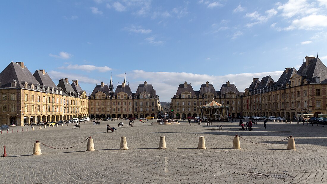
Charleville-Mézières (French pronunciation: [ʃaʁləvil mezjɛʁ] ⓘ) is a commune of northern France, capital of the Ardennes department, Grand Est. Charleville-Mézières is located on the banks of the river Meuse.
You can help expand this article with text translated from the corresponding article in French. (December 2008) Click [show] for important translation instructions.
|
Charleville-Mézières | |
|---|---|
Prefecture and commune | |
 | |
| Coordinates: 49°46′19″N 4°42′58″E | |
| Country | France |
| Region | Grand Est |
| Department | Ardennes |
| Arrondissement | Charleville-Mézières |
| Canton | Charleville-Mézières-1, 2, 3 and 4 |
| Intercommunality | CA Ardenne Métropole |
| Government | |
| • Mayor (2020–2026) | Boris Ravignon[1] |
Area 1 | 31.44 km2 (12.14 sq mi) |
| Population (2022)[2] | 45,634 |
| • Density | 1,500/km2 (3,800/sq mi) |
| Demonym | French: Carolomacérien or Carolomacérienne |
| Time zone | UTC+01:00 (CET) |
| • Summer (DST) | UTC+02:00 (CEST) |
| INSEE/Postal code | 08105 /08000 |
| Elevation | 133–323 m (436–1,060 ft) (avg. 148 m or 486 ft) |
| 1 French Land Register data, which excludes lakes, ponds, glaciers > 1 km2 (0.386 sq mi or 247 acres) and river estuaries. | |
History
Summarize
Perspective

Charleville and Mézières were originally separate communities on opposite banks of the Meuse, about 1.2 km (0.75 mi) from one another.[3]
Charleville was founded by Charles Gonzaga, the 8th duke of Mantua, in 1606. Its inhabitants were known as Carolopolitans (Carolopolitains or Carolopolitaines). It was prosperous from the 17th century, although its fortifications were dismantled under Louis XIV in 1687 and it passed into French hands in 1708. It was plundered by the Prussians in 1815. France's royal armaments factory was formerly located there and gave its name to the Charleville musket, before being relocated and divided between Tulle and Châtellerault. In the 19th century, the city continued to produce arms through private firms, as well as nails, hardware, wine, spirits, coal, iron, and slate. It boasted a spacious port, a theatre, a large public library, and a museum of natural history.[3]
The inhabitants of Mézières were known as Macerians (Macériens or Macériennes).
By the mid-19th century, the two towns were linked by a suspension bridge.[3] It was occupied by the German Empire in the First World War and by Nazi Germany in World War II - the town served as the center of the Oberste Heeresleitung (OHL) for 26 days during World War I. The present commune was established in 1966, the year after another commune, Le Theux, had been merged into Mézières. The entire resultant commune has a population of about 51,000.

Climate
Summarize
Perspective
With an annual average of 10 °C (50 °F), Charleville-Mézières is generally the coolest city of France. Winters are long, cold and gloomy while summers are interchangeably warm or hot but sometimes, even in the middle of July, night temperatures can drop below 5 °C (41 °F). Under the Köppen-Geiger climate classification, Charleville-Mézières features a temperate oceanic climate (Cfb) with strong continental influences (Dfb). The climate is vastly affected by the low mountain Ardennes range nearby. The proximity results in moisture being trapped and excessive precipitation occurs as a result when compared to other parts of northern France. Temperature inversion is also common, which results in strong cold snaps compared to the oceanic climates further west. This results in overnight temperatures below −10 °C (14 °F) happening during most winters as the cold air descends at night. Similar patterns replicate year round, causing Charleville-Mezières to have cooler summer nights than Nordic coastal areas near the Arctic Circle. The intermittent frosts in May and September also result in a short growing season.
| Climate data for Charleville-Mézières (1991–2020 averages), extremes since 1940 | |||||||||||||
|---|---|---|---|---|---|---|---|---|---|---|---|---|---|
| Month | Jan | Feb | Mar | Apr | May | Jun | Jul | Aug | Sep | Oct | Nov | Dec | Year |
| Record high °C (°F) | 15.0 (59.0) |
17.5 (63.5) |
22.0 (71.6) |
28.1 (82.6) |
30.7 (87.3) |
34.9 (94.8) |
39.2 (102.6) |
37.0 (98.6) |
34.4 (93.9) |
27.7 (81.9) |
19.9 (67.8) |
15.7 (60.3) |
39.2 (102.6) |
| Mean maximum °C (°F) | 12.4 (54.3) |
13.6 (56.5) |
18.7 (65.7) |
23.3 (73.9) |
27.1 (80.8) |
30.2 (86.4) |
31.9 (89.4) |
31.5 (88.7) |
26.6 (79.9) |
22.0 (71.6) |
16.2 (61.2) |
12.4 (54.3) |
33.5 (92.3) |
| Mean daily maximum °C (°F) | 5.6 (42.1) |
6.9 (44.4) |
11.3 (52.3) |
15.3 (59.5) |
19.0 (66.2) |
22.1 (71.8) |
24.1 (75.4) |
23.9 (75.0) |
20.0 (68.0) |
15.0 (59.0) |
9.3 (48.7) |
6.1 (43.0) |
14.9 (58.8) |
| Daily mean °C (°F) | 2.7 (36.9) |
3.1 (37.6) |
6.2 (43.2) |
9.1 (48.4) |
12.8 (55.0) |
16.0 (60.8) |
18.0 (64.4) |
17.6 (63.7) |
14.1 (57.4) |
10.4 (50.7) |
6.1 (43.0) |
3.3 (37.9) |
10.0 (49.9) |
| Mean daily minimum °C (°F) | −0.3 (31.5) |
−0.6 (30.9) |
1.0 (33.8) |
2.8 (37.0) |
6.6 (43.9) |
9.9 (49.8) |
11.8 (53.2) |
11.2 (52.2) |
8.2 (46.8) |
5.8 (42.4) |
2.8 (37.0) |
0.4 (32.7) |
5.0 (40.9) |
| Mean minimum °C (°F) | −9.7 (14.5) |
−8.9 (16.0) |
−6.4 (20.5) |
−4.2 (24.4) |
−0.4 (31.3) |
3.2 (37.8) |
5.7 (42.3) |
4.7 (40.5) |
1.2 (34.2) |
−2.0 (28.4) |
−5.2 (22.6) |
−8.2 (17.2) |
−12.0 (10.4) |
| Record low °C (°F) | −17.5 (0.5) |
−16.7 (1.9) |
−13.8 (7.2) |
−8.5 (16.7) |
−4.4 (24.1) |
−2.4 (27.7) |
1.7 (35.1) |
0.4 (32.7) |
−2.0 (28.4) |
−6.7 (19.9) |
−11.8 (10.8) |
−16.4 (2.5) |
−17.5 (0.5) |
| Average precipitation mm (inches) | 100.4 (3.95) |
78.3 (3.08) |
68.6 (2.70) |
56.6 (2.23) |
67.6 (2.66) |
66.8 (2.63) |
72.3 (2.85) |
74.4 (2.93) |
63.4 (2.50) |
80.1 (3.15) |
83.8 (3.30) |
116.1 (4.57) |
928.4 (36.55) |
| Average precipitation days (≥ 1 mm) | 13.3 | 11.3 | 11.1 | 9.2 | 10.2 | 9.8 | 10.0 | 10.0 | 9.1 | 11.2 | 12.8 | 14.0 | 132 |
| Mean monthly sunshine hours | 50 | 69 | 128 | 177 | 197 | 203 | 214 | 199 | 153 | 97 | 48 | 41 | 1,576 |
| Source 1: Météo France[4] | |||||||||||||
| Source 2: Infoclimat [5] | |||||||||||||
Population
In the table and graph below, data for 1962 and earlier refer to the old commune of Charleville, before the merger with Étion, Mézières, Mohon and Montcy-Saint-Pierre.[6]
|
| ||||||||||||||||||||||||||||||||||||||||||||||||||||||||||||||||||||||||||||||||||||||||||||||||||||||||||||
| |||||||||||||||||||||||||||||||||||||||||||||||||||||||||||||||||||||||||||||||||||||||||||||||||||||||||||||
| Source: EHESS[6] and INSEE (1968-2017)[7] | |||||||||||||||||||||||||||||||||||||||||||||||||||||||||||||||||||||||||||||||||||||||||||||||||||||||||||||
Culture
Puppetry is an important part of the cultural life of Charleville-Mézières, which is called the "World Capital of Puppetry Arts". An international puppet festival has been held there every three years since 1961, and became a biennial event in 2011.[8] The town is also home to the world headquarters of UNIMA[9] as well as the International Puppetry Institute (French: Institut International de la Marionnette),[10] which is housed in a historic building featuring a giant automaton of a puppeteer who performs a puppet show every hour on the hour. The École Nationale Supérieure des Arts de la Marionnette (ESNAM), a college which offers a higher education in puppetry, is also situated in Charleville-Mézières. [11]
The poet Arthur Rimbaud (1854–1891) was born in Charleville. The Rimbaud museum is located in the old water mill (Le Vieux Moulin) to the north of the town.
Charleville served as the starting location for two seasons of the travel competition show Jet Lag: The Game.[12]
Transport
The local network of public buses within the Ardenne Métropole, TAC, is operated by RATP Dev.[13] The Charleville-Mézières railway station offers connections to Paris (by TGV), Reims, Lille, Metz and regional destinations.
Sport
OFC Charleville represent the town at association football. Étoile de Charleville-Mézières is a basketball club.
Famous residents


- Louise Bellocq (1919–1968), French writer, winner of the 1960 Prix Femina, was born in Charleville
- Olivier Brochard (born 1967), former football player
- Antoine Louis Dugès (1797–1838), obstetrician and naturalist
- François Habeneck (1781–1849), violinist born in Mézières
- Adolphe-Hippolyte Couveley (1802–1867), painter born in Charleville
- Edmond Louis Alexis Dubois-Crancé (1747–1814), general, French revolutionary, minister of war, 12th President of the National Convention.[14]
- Louis Dufour (1652–1733), the abbé of Longuerue, was born in Charleville.[15]
- Jean Nicolas Pierre Hachette (1769–1834), mathematician born in Mézières.[16]
- Henri Mialaret (1855–1919), sailor
- Gaspard Monge (1746–1818), mathematician, taught at the École royale du génie de Mézières.[17]
- Étienne Riché (1883–1934), politician and banker, twice under-secretary of state and deputy for the Ardennes, born in Charleville
- Arthur Rimbaud (1854–1891), the French poet, was born in Charleville.[18]
- Félix Savart (1791–1841), physicist and mathematician born in Mézières
- Louis Tirman (1837–1899), lawyer and civil servant, Governor General of Algeria from 1881 to 1891
- Natalis de Wailly (1805–1886), 19th-century historian and palaeographer born in Charleville
International relations
Charleville-Mézières is twinned with:[19]
 Dülmen, Germany
 Euskirchen, Germany
 Nordhausen, Germany
 Nevers, France
 Mantua, Italy
 Tolosa, Spain
See also
Notes
References
External links
Wikiwand - on
Seamless Wikipedia browsing. On steroids.


