Charente-Maritime
Department of France From Wikipedia, the free encyclopedia

Charente-Maritime (French pronunciation: [ʃaʁɑ̃t maʁitim] ; Poitevin-Saintongeais: Chérente-Marine; Occitan: Charanta Maritima) is a département in the Nouvelle-Aquitaine region on the southwestern coast of France. Named after the river Charente, its prefecture is La Rochelle. As of 2019, it had a population of 651,358 with an area of 6,864 square kilometres (2,650 sq mi).[3]
Charente-Maritime | |
|---|---|
.jpg) Prefecture building in La Rochelle | |
 Flag  Coat of arms | |
 Location of Charente-Maritime in France | |
| Coordinates: 45°57′N 0°58′W | |
| Country | France |
| Region | Nouvelle-Aquitaine |
| Prefecture | La Rochelle |
| Subprefectures | Jonzac Rochefort Saintes Saint-Jean-d'Angély |
| Government | |
| • President of the Departmental Council | Sylvie Marcilly[1] (DVD) |
| Area | |
| • Total | 6,864 km2 (2,650 sq mi) |
| Population (2021)[2] | |
| • Total | 661,404 |
| • Rank | 40th |
| • Density | 96/km2 (250/sq mi) |
| Time zone | UTC+1 (CET) |
| • Summer (DST) | UTC+2 (CEST) |
| Area code | FR-17 |
| Department number | 17 |
| Arrondissements | 5 |
| Cantons | 27 |
| Communes | 463 |
| ^1 French Land Register data, which exclude estuaries and lakes, ponds and glaciers larger than 1 km2 | |
History


Previously a part of the provinces of Saintonge and Aunis, Charente-Inférieure was one of the 83 original département created during the French Revolution on 4 March 1790.[4] On 4 September 1941, during World War II, it was renamed as Charente-Maritime.[5]
When the département was first organised, the commune of Saintes was designated as the prefecture of the département (Saintes had previously been the capital of Saintonge). This changed in 1810 when Napoleon passed an imperial decree to move the prefecture to La Rochelle.[6]
During World War II, the département was invaded by the German Army and became part of occupied France.[7] To provide defence against a possible beach landing by the Allies, the Organisation Todt constructed a number of sea defences in the area.[8] Defences such as pillboxes are particularly noticeable on the beaches of the presqu'île d'Arvert[9] and the island of Oléron.[10]
At the end of the war, the two last pockets of German resistance were both in this area: at La Rochelle in the north and Royan in the south. Despite Royan having been nearly destroyed during an RAF bombing raid on 5 January 1945,[11] the town was not liberated by the French Forces of the Interior until April of the same year.[12] La Rochelle was finally liberated on 9 May 1945.[13]
Geography

Charente-Maritime is part of the Nouvelle-Aquitaine administrative region. It is surrounded by the départements of Gironde, Charente, Deux-Sèvres, Dordogne and Vendée. It has a land area of 6864 km2 and 651,358 inhabitants as of 2019.[3]
The important rivers are the Charente and its tributaries, the Boutonne and the Seugne, along with the Sèvre Niortaise, the Seudre and the Garonne, in its downstream part, which is the estuary of the Gironde.
The département includes the islands of Île de Ré, Île d'Aix, Ile d'Oléron and Île Madame.
The département forms the northern part of the Aquitaine Basin. It is separated from the Massif Armoricain by the Marais Poitevin to the north-west and from the Parisian basin by the Seuil du Poitou to the north-east. The highest point in the département is in the woods of Chantemerlière, near the commune of Contré in the north-east, and rises to 173 m.[14]
Administrative borders
| Direction | Neighbour |
|---|---|
| North | Vendée of Pays de la Loire and Deux-Sèvres |
| East | Charente and Dordogne |
| West | Atlantic Ocean |
| South | Gironde and Gironde estuary |
Principal towns
The most populous commune is La Rochelle, the prefecture. As of 2019, there are 7 communes with more than 8,000 inhabitants:[15]
| Commune | Population (2019) |
|---|---|
| La Rochelle | 77,205 |
| Saintes | 25,287 |
| Rochefort | 23,584 |
| Royan | 18,419 |
| Aytré | 9,247 |
| Périgny | 8,684 |
| Tonnay-Charente | 8,097 |
Climate
The climate is mild and sunny, with less than 900 mm of precipitation per year[16] and with insolation being remarkably high, in fact, the highest in Western France including southernmost sea resorts such as Biarritz.[17] Average extreme temperatures vary from 39 °C (102 °F)[18] in summer to −5 °C (23 °F) in winter (as of 2022).[19]
Economy
The economy of Charente-Maritime is based on three major sectors: tourism, maritime industry, and manufacturing. Cognac and pineau are two of the major agricultural products with maize and sunflowers being the others.[20]
Charente-Maritime is the headquarters of the major oyster producer Marennes-Oléron.[21] Oysters cultivated here are shipped across Europe.
Rochefort is a shipbuilding site and has been a major French naval base since 1665.[22]
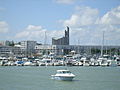
La Rochelle is a seat of major French industry. Just outside the city, in Aytré, is a factory for the French engineering giant Alstom, where the TGV, the cars for the Paris and other metros are manufactured (see fr:Alstom Aytré).[23] It is a popular venue for tourism, with its picturesque medieval harbour and city walls.
Demographics
The inhabitants of the département are called Charentais-Maritimes.
|
| |||||||||||||||||||||||||||||||||||||||||||||||||||||||||||||||||||||||||||||||||||||||
| ||||||||||||||||||||||||||||||||||||||||||||||||||||||||||||||||||||||||||||||||||||||||
| Sources:[24][25] | ||||||||||||||||||||||||||||||||||||||||||||||||||||||||||||||||||||||||||||||||||||||||
Politics
Departmental Council of Charente-Maritime

The President of the Departmental Council has been Dominique Bussereau (LR) since 2008.[26] He was replaced by Sylvie Marcilly after the departmental elections of June 2021.[27][28]
National representation
In the 2022 legislative election, Charente-Maritime elected the following members of the National Assembly:
In the Senate, Charente-Maritime is represented by three members: Daniel Laurent (since 2008), Corinne Imbert (since 2014) and Mickaël Vallet (since 2020).[30]
Tourism
Popular destinations include La Rochelle, Royan, Saintes, Saint-Jean-d'Angély, Rochefort, the Île d'Aix, Île de Ré and Île d'Oléron.
The department is served by the TGV at Surgères and La Rochelle. It can also be reached by motorway by the A10 (E5, Paris-Bordeaux) and A837 (E602, Saintes-Rochefort).

 Royan, a seaside resort
 Oyster farms on the island of Oléron


See also
References
External links
Wikiwand in your browser!
Seamless Wikipedia browsing. On steroids.
Every time you click a link to Wikipedia, Wiktionary or Wikiquote in your browser's search results, it will show the modern Wikiwand interface.
Wikiwand extension is a five stars, simple, with minimum permission required to keep your browsing private, safe and transparent.