Bratislava Region
Region of Slovakia From Wikipedia, the free encyclopedia

The Bratislava Region (Slovak: Bratislavský kraj, pronounced [ˈbracislawskiː ˈkraj]; German: Pressburger/Bratislavaer Landschaftsverband (until 1919); Hungarian: Pozsonyi kerület) is one of the administrative regions of Slovakia. Its capital is Bratislava. The region was first established in 1923 and its present borders exist from 1996. It is the smallest of the eight regions of Slovakia as well as the most urbanized, most developed and most productive by GDP per capita.
Bratislava Region
Bratislavský kraj | |
|---|---|
.jpg) | |
 Flag  Coat of arms | |
 | |
| Country | Slovakia |
| Capital | Bratislava |
| Government | |
| • Body | County Council of Bratislava Region |
| • Governor | Juraj Droba (SaS) |
| Area | |
• Total | 2,053 km2 (793 sq mi) |
| Highest elevation | 754 m (2,474 ft) |
| Lowest elevation | 123 m (404 ft) |
| Population (2021-01-01)[1] | |
• Total | 719,537 |
| • Density | 350/km2 (910/sq mi) |
| GDP | |
| • Total | €30.709 billion (2022) |
| • Per capita | €42,679 (2022) |
| ISO 3166 code | SK-BL |
| HDI (2022) | 0.945 [4] very high · 1st |
| Website | bratislavskykraj |
Geography
The region is located in the south-western part of Slovakia and has an area of 2,053 km2 and a population of 622,706 (2009). The region is split by the Little Carpathians which start in Bratislava and continue north-eastwards; these mountains separate two lowlands, the Záhorie lowland in the west and the fertile Danubian Lowland in the east, which grows mainly wheat and maize. Major rivers in the region are the Morava River, the Danube and the Little Danube; the last of these, together with the Danube, encircle the Žitný ostrov in the south-east. There are three protected landscape areas in the region: the Little Carpathians, Záhorie and Dunajské luhy. The region borders Trnava Region in the north and east, Győr-Moson-Sopron county in Hungary in the south, Burgenland in Austria in the south-west and Lower Austria in the west.
History
Summarize
Perspective
The first known permanent settlement of the area of today's Bratislava was the Linear Pottery Culture, around 5000 BC in the Neolithic era. Around 200 BC, the Celtic Boii tribe established an oppidum on the site of today's Bratislava Castle. The Romans established their camp Gerulata on the right bank of the Danube in the 1st century[clarification needed] and remained there until the 4th century. The area was part of the Principality of Nitra and later, in the 9th century, of Great Moravia. From the 10th century onwards, it became part of the Principality of Hungary (later the Kingdom of Hungary) and almost the whole area was part of Pozsony county (the exception being three villages south of Bratislava which were part of Moson county). After the break-up of Austria-Hungary in 1918, region was newly defined in 1923 and present Bratislava region approximately copies its 1923 borders. Bratislava Regio was abolished in 1928 and replaced by a new territorial unit called the "Slovak Land". During the WWII Slovak Republic, Bratislava county was restored, albeit with somewhat modified borders. After the restoration of Czechoslovakia, the pre-breakup status was restored. From 1949 to 1960 a unit named Bratislava Region existed, but it was replaced in 1960 by the Western Slovak Region (except[clarification needed] from 1 July 1969 to 28 December 1970; Bratislava was partly separate from 1968, and from 1971 it was a separate region). After abolition of the regions in 1990, the current system was introduced in 1996. Since the administrative regions became autonomous in 2002, it has been governed by the Bratislava Self-Governing Region.
Demographics
Although it is the smallest region of Slovakia by area, it does not have the lowest population. The largest city is Bratislava (425,459) and the second largest is Pezinok (21,334). The region has a high level of urbanization (83.2%). According to the 2001 census, there were 599,015 inhabitants in the region, with most of them being Slovaks (91.2%), with minorities of Hungarians (4.6%) and Czechs (1.6%).[7]
Economy
The economy of the Bratislava Region accounts for about a quarter(EUR 20 billion) of the Slovak GDP. Bratislava has one of the highest GDP per capita at PPP of among whole E.U. €51,200(~$70,000).[8] It is marked by a strong tertiary sector, while the primary sector has a share of only around 1% and the secondary sector around 20%.[9] Important branches include chemical, automobile, machine, electrotechnical and food industries.[10]
Politics
Summarize
Perspective
This section needs to be updated. (January 2025) |
The current governor of the Bratislava region is Juraj Droba (SaS). He won with 20.4&%. In the 2017 election, the regional parliament was elected as well:
County Council of Bratislava region | |
|---|---|
| |
| Type | |
| Type | |
| Houses | County Council |
| Leadership | |
Governor | |
| Structure | |
| Seats | 53 |
.svg) | |
Political groups |
|
| Elections | |
Last election | 29 October 2022 |
| Meeting place | |
 Governor's office, Bratislava | |
| Website | |
| Council of Bratislava region | |
2017 elections
Droba (SaS) won the 2017 governor's elections against several other candidates.
 | |||||
| Political party | Seats won | +/- | Percentage | Electoral leader[11] | |
|---|---|---|---|---|---|
| Independents | 25 | 50,00% | Martin Zaťovič | ||
| Centre-right coalition[12] | 17 | 34,00% | Elena Pätoprstá | ||
| Coalition led by Smer–SD[13] | 6 | 12,00% | Vladimír Bajan | ||
| Doma Dobre | 1 | 2,00% | Peter Tydlitát | ||
| Nezávislé fórum | 1 | 2,00% | Alžbeta Ožvaldová | ||
2013 elections
Pavol Frešo (SDKÚ–DS) won the 2013 governor's elections over the centre-left candidate Monika Beňová (Smer–SD). Pavol Frešo was also supported by SaS, OKS, Most–Híd, SMK-MKP, KDH and SZ.
 | |||||
| Political party | Seats won | +/- | Percentage | Electoral leader | |
|---|---|---|---|---|---|
| KDH[14] | 9 | 20,46% | Dušan Pekár | ||
| Most–Híd[15] | 7 | 15,91% | Attila Horváth | ||
| SaS[16] | 7 | 15,91% | Vladimír Sloboda | ||
| SDKÚ–DS[17] | 6 | 13,64% | Ivo Nesrovnal | ||
| Independents | 6 | 13,64% | Rudolf Kusý | ||
| SMK-MKP[18] | 3 | 6,82% | Zuzana Schwartzová | ||
| OKS[19] | 2 | 4,55% | Ondrej Dostál | ||
| Smer–SD | 1 | 2,27% | Peter Fitz | ||
| NaS–NS | 1 | 2,27% | Oskar Dobrovodský | ||
| Nezávislé fórum | 1 | 2,27% | Marta Černá | ||
| ZZ–DÚ | 1 | 2,27% | Elena Pätoprstá | ||
2009 elections
The 2009 regional elections were won by Pavol Frešo (SDKÚ–DS) over the independent candidate Vladimír Bajan. Pavol Frešo was also supported by SaS, OKS, SMK-MKP and KDH.
 | |||||
| Political party | Seats won | +/- | Percentage | Electoral leader | |
|---|---|---|---|---|---|
| Smer–SD[20] | 13 | 29,55% | Milan Ftáčnik | ||
| SDKÚ–DS[21] | 10 | 22,73% | Ladislav Snopko | ||
| KDH[22] | 8 | 18,18% | Dušan Pekár | ||
| SMK-MKP[23] | 5 | 11,36% | Zuzana Schwartzová | ||
| OKS[24] | 3 | 6,82% | František Šebej | ||
| Independents | 2 | 4,55% | Rudolf Kusý | ||
| ĽS–HZDS[25] | 1 | 2,27% | Ladislav Balla | ||
| Most–Híd | 1 | New | 2,27% | Alžbeta Ožvaldová | |
| SaS | 1 | New | 2,27% | Anna Zemanová | |
Administrative division
The Bratislava Region consists of 8 districts: Malacky, Pezinok, Senec and 5 districts of Bratislava (Bratislava I – Bratislava V, which form the city of Bratislava).
There are 73 municipalities in the region, of which 7 are towns.
Places of interest
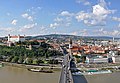
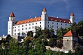
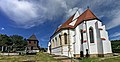
- Bratislava with Bratislava Castle, St Martin's Cathedral, Bridge of the Slovak National Uprising, Grassalkovich Palace etc.
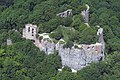
- Devín castle
- Roman military camp Gerulata - inscribed in UNESCO World Heritage List
- Towns with vineyard tradition: Svätý Jur, Modra, Pezinok
- Budmerice chateau
- Červený Kameň Castle
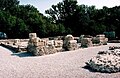
- Sandberg - paleontological site
- Little Carpathians Protected Landscape Area
- Dunajské luhy Protected Landscape Area
- Záhorie Protected Landscape Area
Photo gallery


 Budmerice Chateau
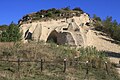 Sandberg, paleontological site
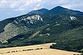


.jpg)

_01.jpg)


_-_Horná_brána.JPG)


Notes
I am Slovakia (6)
STANK (2)
Tím Ružinov (2)
Independent (2)
Voice (1)
Independent (2)
Alliance (1)
Good Choice (1)
References
External links
Wikiwand - on
Seamless Wikipedia browsing. On steroids.