Top Qs
Timeline
Chat
Perspective
Bhojpur District, Nepal
District in Koshi Province, Nepal From Wikipedia, the free encyclopedia
Remove ads
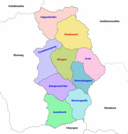
Bhojpur District (Nepali: भोजपुर जिल्ला [bʱod͡zpur] ⓘ) is one of 14 districts of Koshi Province of eastern Nepal. The district's area is 1,507 km2 with a population of 182,459 (2011).[1] The administrative center is Bhojpur. It is surrounded by Dhankuta and Sankhuwasabha in the east, Khotang in the west, again Sankhuwasabha in north-east, Solukhumbu in the north-west and Udayapur in the South.
Remove ads
Remove ads
Etymology
According to the District Coordination Committee Bhojpur, this place was named for the Himalayan birch (Betula utilis; Nepali भोजपत्र bhojpatra), which was found here in large quantities.[2] Pur means 'city'.
Geography and climate
Classified as a hill district, Bhojpur actually spans five of Nepal's eight climate zones.[3] 3% of the district's area is below 300 meters elevation in the Lower Tropical zone and 31% is Upper Tropical from 300 to 1,000 meters. 50% of the land area belongs to the Subtropical Zone between 1,000 and 2,000 meters and 15% is Temperate (2,000 to 3,000 meters). 2% rises higher into the Subalpine Zone.
Remove ads
Divisions
Bhojpur is divided into two urban and seven rural municipalities:
Towns and villages (former VDC)

- Aangtep
- Annapurna
- Baikunthe
- Balankha
- Basikhora
- Basingtharpu
- Bastim
- Bhaisipankha
- Bhubal
- Bhulke
- Bokhim
- Bhojpur
- Boya
- Champe
- Changre
- Charambi
- Chaukidanda
- Chhinamakhu
- Dalgaun
- Deurali
- Dewantar
- Dhodalekhani
- Dobhane
- Dummana
- Gogane
- Gupteshwar
- Hasanpur
- Helauchha
- Homtang
- Jarayotar
- Kimalung
- Keurepani
- Khairang
- Khartimchha
- Khatamma
- Khawa
- Kot
- Kudak Kaule
- Kulunga
- Lekharka
- Mane Bhanjyang
- Mulpani
- Nagi
- Nepaledada
- Okhre
- Pangcha
- Patle Pani
- Pawala
- Pyauli
- Ranibas
- Sangpang
- Sano Dumba
- Shadanand Municipality
- Shyamsila
- Siddheshwar
- Sindrang
- Syamsila
- Taksar
- Thidingkha
- Thulo Dumba
- Timma
- Tiwari Bhanjyang
- Tunggochha
- Yaku
- Yangpang
Demographics
Summarize
Perspective
At the 2021 Nepal census, Bhojpur District had a population of 157,923. Bhojpur had a literacy rate of 78.9% and a sex ratio of 1,019 females per 1,000 males. 55,349 (35.05%) lived in urban areas.[5]
Ethnicity/caste: 34.11% of the population were Rai, 17.66% Chhetri, 10.78% Tamang, 7.65% Newar, 4.94% Magar, 4.58% Bahun, 4.27% Kami, 2.70% Damai, 2.44% Sarki, 2.20% Kulung, 1.88% Bhujel and 1.76% Sherpa.[6]
Religion: 46.39% were Hindu, 36.29% Kirati, 16.04% Buddhist,1.21% Christian and 0.07% others.[7]
As their first language, 47.81% of the population spoke Nepali, 20.04% Bantawa, 7.48% Tamang, 3.52% Magar, 3.29% Newari, 2.90% Kulung, 2.69% Dungmali, 2.19% Sampang, 1.86% Rai, 1.50% Sherpa, 1.49% Chamling.[8] In 2011, 49.08% of the population spoke Nepali as their first language.[9]
Remove ads
2015 Nepal earthquake
The district was affected by an earthquake on 25 April 2015.[10]
See also
References
Further reading
External links
Wikiwand - on
Seamless Wikipedia browsing. On steroids.
Remove ads


