Römerberg
Municipality in Rhineland-Palatinate, Germany From Wikipedia, the free encyclopedia
Römerberg is a municipality in the Rhein-Pfalz-Kreis, in Rhineland-Palatinate, Germany. It is situated on the left bank of the Rhine, approximately 5 kilometres (3.1 mi) southwest of Speyer.
Römerberg | |
|---|---|
 Church of Saint Sigismund in Heiligenstein | |
_COA.svg) Coat of arms | |
Location of Römerberg within Rhein-Pfalz-Kreis district 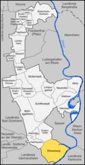 | |
 Römerberg  Römerberg | |
| Coordinates: 49°17′14″N 8°23′52″E | |
| Country | Germany |
| State | Rhineland-Palatinate |
| District | Rhein-Pfalz-Kreis |
| Municipal assoc. | Römerberg-Dudenhofen |
| Subdivisions | 3 |
| Government | |
| • Mayor (2019–24) | Matthias Hoffmann[1] (Greens) |
| Area | |
| • Total | 27.86 km2 (10.76 sq mi) |
| Elevation | 108 m (354 ft) |
| Population (2022-12-31)[2] | |
| • Total | 9,907 |
| • Density | 360/km2 (920/sq mi) |
| Time zone | UTC+01:00 (CET) |
| • Summer (DST) | UTC+02:00 (CEST) |
| Postal codes | 67354 |
| Dialling codes | 06232 |
| Vehicle registration | RP |
| Website | www.roemerberg.de |
History
The municipality of Römerberg was established by the fusion of the municipalities of Berghausen, Heiligenstein and Mechtersheim in 1969. The seat of the municipality is in the village Heiligenstein.
References
Wikiwand in your browser!
Seamless Wikipedia browsing. On steroids.
Every time you click a link to Wikipedia, Wiktionary or Wikiquote in your browser's search results, it will show the modern Wikiwand interface.
Wikiwand extension is a five stars, simple, with minimum permission required to keep your browsing private, safe and transparent.