Belaya (Kama)
River in Bashkortostan, Russia From Wikipedia, the free encyclopedia
River in Bashkortostan, Russia From Wikipedia, the free encyclopedia
The Belaya (/ˈbɛlaɪə/ BEL-y-ə)[a] is a river in Bashkortostan, Russia. Its source lies in the south-western Ural Mountains.
This article needs additional citations for verification. (February 2014) |
| Belaya | |
|---|---|
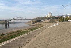
 The Belaya in Ufa | |
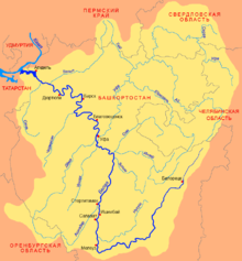
 Belaya basin | |
| Location | |
| Country | Russia |
| Region | Bashkortostan |
| Physical characteristics | |
| Source | Iremel mountains |
| • location | Novokhusainovo, Uchalinsky District |
| • coordinates | 54°33′0″N 59°3′0″E |
| • elevation | 749 m (2,457 ft) |
| Mouth | Kama |
• location | Nizhnekamsk Reservoir |
• coordinates | 55°53′14″N 53°36′14″E |
• elevation | 57 m (187 ft) |
| Length | 1,430 km (890 mi) |
| Basin size | 142,000 km2 (55,000 sq mi) |
| Discharge | |
| • average | 858 m3/s (30,300 cu ft/s) (near Birsk) |
| Basin features | |
| Progression | Kama→ Volga→ Caspian Sea |
 | |
It is 1,430 kilometres (890 mi) long, and its drainage basin covers 142,000 square kilometres (55,000 sq mi).[1][2]
Settlements along the Belaya include Beloretsk, Sterlitamak, Ufa (at the confluence with the river Ufa), and Birsk. The Belaya flows into the Kama near Neftekamsk.

The largest tributaries of the Belaya are, from source to mouth:[1]
Seamless Wikipedia browsing. On steroids.
Every time you click a link to Wikipedia, Wiktionary or Wikiquote in your browser's search results, it will show the modern Wikiwand interface.
Wikiwand extension is a five stars, simple, with minimum permission required to keep your browsing private, safe and transparent.