Ballyvolane, Cork
Suburb of Cork, Ireland From Wikipedia, the free encyclopedia
Ballyvolane (Irish: Baile Uí Mhaoláin)[1] is a townland and suburb of Cork on the north side of the city. The townland of Ballyvolane is in the civil parish of St. Anne's Shandon.[2] It is within the Cork North-Central Dáil constituency.
Ballyvolane
Baile Uí Mhaoláin | |
|---|---|
Suburb | |
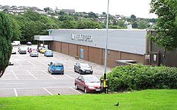
 Shopping centre in Ballyvolane | |
| Coordinates: 51°55′01″N 8°26′49″W | |
| Country | Ireland |
| Province | Munster |
| Administrative area | Cork (city) |
| Irish Grid Reference | W692739 |
The two schools in Ballyvolane are St. Aidan's Community Community College and Scoil Oilibhéir, and the local Roman Catholic Church is Saint Oliver's, built in the 1990s.[3] Nearby archaeological sites, protected under the National Monuments Acts, include a number of burnt mounds and fulacht fiadh.[3][4][5]
Ballyvolane Shopping Centre is anchored by Dunnes Stores and first opened in 1980.[6]
In June 2012, several households in the area were damaged by flooding.[7]
See also
References
Wikiwand in your browser!
Seamless Wikipedia browsing. On steroids.
Every time you click a link to Wikipedia, Wiktionary or Wikiquote in your browser's search results, it will show the modern Wikiwand interface.
Wikiwand extension is a five stars, simple, with minimum permission required to keep your browsing private, safe and transparent.

