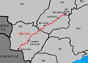
BR-060 is a federal highway of Brazil.[1] The 1329 kilometre road connects Brasília to Bela Vista, on the Paraguayan border.[2][3]
| BR-060 | |
|---|---|
 | |
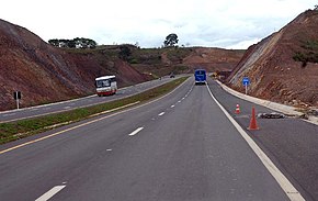
 BR-060 in Goiânia, going to Anápolis. | |
| Route information | |
| Length | 1,329.3 km (826.0 mi) |
| Major junctions | |
| North end | Brasília, Distrito Federal |
| South end | Bela Vista, Mato Grosso do Sul |
| Location | |
| Country | Brazil |
| Highway system | |
It is also designated as part of the Belém–Brasília Highway, in its stretch between Brasília and Anápolis.
Duplication
In the Federal District and in the State of Goiás, the highway has 521 km duplicated, between Brasilia and Jataí. The section between Brasília and Goiânia fully doubled in 2007. The section between Goiânia and Jataí doubled in 2012.[4][5]
Economic Importance

The highway helps in the flow of agricultural production in the Center-West Region, which specializes in: soybeans, corn, sugarcane, tomatoes, beans, in the planting of eucalyptus for the production of cellulose and paper, and in cattle raising. Goiás and Mato Grosso do Sul also have considerable mineral exploration, producing a lot of iron ore, nickel and copper, in addition to gold, manganese and niobium. The BR-060 will in the future serve as a link with the Bioceanic Corridor that is being built with 3 other South American countries, connecting Campo Grande to Antofagasta, passing through Paraguay, northern Argentina and northern Chile. [6][7][8][9][10][11][12][13]
The highway is also of tourist importance, as it connects to Pantanal, the largest wetland in the world, and Bonito, an important Brazilian tourist city. [14][15][16][17][18]
References
Wikiwand in your browser!
Seamless Wikipedia browsing. On steroids.
Every time you click a link to Wikipedia, Wiktionary or Wikiquote in your browser's search results, it will show the modern Wikiwand interface.
Wikiwand extension is a five stars, simple, with minimum permission required to keep your browsing private, safe and transparent.

