Armação de Pêra
Civil parish in Algarve, Portugal From Wikipedia, the free encyclopedia
Armação de Pêra is a town (vila) and Portuguese parish (freguesia) in the municipality of Silves.[1] The population in 2011 was 4,867,[2] in an area of 7.99 km2.[3] The village used to be called Pêra de Baixo or Lower Pêra[4] to distinguish it from the present Pêra, which was then named Pêra de Cima or Upper Pêra.[5]
Armação de Pêra | |
|---|---|
 Beach of Armação de Pêra | |
 Flag  Coat of arms | |
 Armação de Pêra Location in Portugal | |
| Coordinates: 37.102°N 8.361°W | |
| Country | |
| Region | Algarve |
| Intermunic. comm. | Algarve |
| District | Faro |
| Municipality | Silves |
| Area | |
| • Total | 7.99 km2 (3.08 sq mi) |
| Population (2011) | |
| • Total | 4,867 |
| • Density | 610/km2 (1,600/sq mi) |
| Time zone | UTC±00:00 (WET) |
| • Summer (DST) | UTC+01:00 (WEST) |
| Postal code | 8365 |
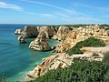
The town (vila in Portuguese) of Armação de Pêra is a popular tourist center with fine beaches, hotels, cafés and restaurants.[5] It is on a broad bay that stretches from Pont da Galé to Senhora da Rocha. Its beaches[6] extend from Praia dos Pescadores[6] or the Fishermen's Beach, to Salomão beach,[6] including those of Maré Grande[6] and Beijinhos.[5]
The town is one of the last places in the region where fishing boats are launched from and recovered to the actual beach. There is no harbour.
Location
The town is 20.9 kilometres (13.0 mi) southeast of Silves, 3 kilometres (1.9 mi) from Alcantarilha, 1.5 kilometres (0.93 mi) from Pêra and 263 kilometres (163 mi) south south east of Lisbon.[5]
Gallery
 Chapel of Santo António de Armação de Pêra


References
Wikiwand in your browser!
Seamless Wikipedia browsing. On steroids.
Every time you click a link to Wikipedia, Wiktionary or Wikiquote in your browser's search results, it will show the modern Wikiwand interface.
Wikiwand extension is a five stars, simple, with minimum permission required to keep your browsing private, safe and transparent.