Arabi, Georgia
Town in Georgia, United States From Wikipedia, the free encyclopedia
Town in Georgia, United States From Wikipedia, the free encyclopedia
Arabi is a town in Crisp County, Georgia, United States. As of 2020 its population was 447.
Arabi, Georgia | |
|---|---|
 Arabi City Hall, May 2018 | |
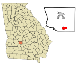
 Location in Crisp County and the state of Georgia | |
| Coordinates: 31°50′1″N 83°44′6″W | |
| Country | United States |
| State | Georgia |
| County | Crisp |
| Area | |
| • Total | 6.44 sq mi (16.69 km2) |
| • Land | 6.29 sq mi (16.30 km2) |
| • Water | 0.15 sq mi (0.38 km2) |
| Elevation | 440 ft (134 m) |
| Population (2020) | |
| • Total | 447 |
| • Density | 71.01/sq mi (27.42/km2) |
| Time zone | UTC-5 (Eastern (EST)) |
| • Summer (DST) | UTC-4 (EDT) |
| ZIP code | 31712 |
| Area code | 229 |
| FIPS code | 13-02564[2] |
| GNIS feature ID | 0331047[3] |
| Website | cityofarabi |
The first permanent settlement at Arabi was made in 1888.[4] According to tradition, the name "Arabi" was coined after a local surname.[4] The town was chartered in 1891.[5]
As of the census[2] of 2000, there were 456 people, 185 households, and 120 families residing in the town. By the 2020 census, its population was 447.
Arabi is located in southern Crisp County at 31°50′1″N 83°44′6″W (31.833473, -83.734912).[7] U.S. Route 41 passes through the center of the town as Bedgood Avenue, leading north 9 miles (14 km) to Cordele, the county seat, and south 10 miles (16 km) to Ashburn. Interstate 75 passes through the eastern side of the town, with access from Exit 92, and leads north 73 miles (117 km) to Macon and south 75 miles (121 km) to Valdosta.
According to the United States Census Bureau, Arabi has a total area of 6.4 square miles (16.6 km2), of which 6.3 square miles (16.3 km2) is land and 0.12 square miles (0.3 km2), or 1.81%, is water.[8]
Seamless Wikipedia browsing. On steroids.
Every time you click a link to Wikipedia, Wiktionary or Wikiquote in your browser's search results, it will show the modern Wikiwand interface.
Wikiwand extension is a five stars, simple, with minimum permission required to keep your browsing private, safe and transparent.