Top Qs
Timeline
Chat
Perspective
Aquitania, Boyacá
Municipality and town in Boyacá Department, Colombia From Wikipedia, the free encyclopedia

Remove ads
Aquitania is a town and municipality in Boyacá Department, Colombia, part of the Sugamuxi Province, a subregion of Boyaca. Aquitania borders Sogamoso, Cuítiva and Mongua in the north, Zetaquirá, San Eduardo and Páez in the south, Labranzagrande, Pajarito, Recetor and Chámeza in the east and Cuítiva, Tota, Zetaquirá and San Eduardo in the west. The urban centre is situated on the Altiplano Cundiboyacense as one of the highest towns at an altitude of 3,030 metres (9,940 ft). The town of Aquitania borders Lake Tota to the east.[1]

.svg)

Remove ads

Remove ads
Climate
Remove ads
History
Before the Spanish conquest of the Muisca, Aquitania was called "Guáquia" and was inhabited by the indigenous Muisca people. The area was ruled by the iraca of Sugamuxi. Conquistador Juan de San Martín reached the area in 1540. Modern Aquitania was founded in 1777.[1]
Economy
Commercial agricultural products grown in Aquitania include onions, peas, corn, and potatoes.[1]
Born in Aquitania
- Arsenio Chaparro Cardoso, former professional cyclist[3]
- Freddy Montaña, professional cyclist
Gallery
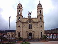 Church of Aquitania
 Onion fields in Aquitania
 Onion fields
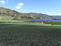 Onion fields
 Monument to the onion farmers


References
Wikiwand - on
Seamless Wikipedia browsing. On steroids.
Remove ads