Khirbat al-Mansura
Village in Haifa, Mandatory Palestine From Wikipedia, the free encyclopedia

Khirbat Al-Mansura was a Palestinian village in the Haifa Subdistrict. It was probably depopulated during an offensive by the Carmeli Brigade at the end of April 1948. It was located 18.5 km southeast of Haifa with a mostly Druze population.[2] Khirbat Al-Mansura contained the ruins of building foundations and rock-cut tombs.
Khirbat Al-Mansura
خربة المنصورة | |
|---|---|
Village | |
| Etymology: Jelamet el Mansûrah, the hill of Mansûreh[1] | |
.jpg) 1870s map 1870s map .jpg) 1940s map 1940s map.jpg) modern map modern map .jpg) 1940s with modern overlay map 1940s with modern overlay mapA series of historical maps of the area around Khirbat al-Mansura (click the buttons) | |
 Khirbat Al-Mansura Location within Mandatory Palestine | |
| Coordinates: 32°40′28″N 35°05′59″E | |
| Palestine grid | 159/231 |
| Geopolitical entity | Mandatory Palestine |
| Subdistrict | Haifa |
| Date of depopulation | April 28, 1948 |
History
In 1863, the Victor Guérin described El Mansoura as a small Druze village.[3]
In the 1931 census of Palestine it was counted under Daliyat al-Karmel, together with Deir el Muhraqa.[4]
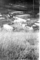 Israeli army camp at Mansura, 1948
 Israeli army camp at Khirbet al-Mansura. 1948


References
Bibliography
External links
Wikiwand in your browser!
Seamless Wikipedia browsing. On steroids.
Every time you click a link to Wikipedia, Wiktionary or Wikiquote in your browser's search results, it will show the modern Wikiwand interface.
Wikiwand extension is a five stars, simple, with minimum permission required to keep your browsing private, safe and transparent.