Abura/Asebu/Kwamankese District
District in Central, Ghana From Wikipedia, the free encyclopedia
Abura/Asebu/Kwamankese District is one of the twenty-two districts in Central Region, Ghana.[1] Originally created as an ordinary district assembly in 1988, which was created from the former Mfantsiman District Council. The district assembly is located in the southwest part of Central Region and has Essakyir as its capital town.[3]
Abura/Asebu/Kwamankese District | |
|---|---|
 Fort Nassau in Moree, Ghana | |
 Districts of Central Region | |
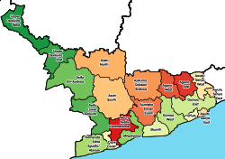
Location of Abura/Asebu/Kwamankese District within Central | |
| Coordinates: 5°18′N 1°13′W | |
| Country | Ghana |
| Region | |
| Capital | Abura-Dunkwa |
| Government | |
| • District Executive | William Atta-Mends[1] |
| Area | |
• Total | 324 km2 (125 sq mi) |
| Population (2021) | |
• Total | 124,465[2] |
| Time zone | UTC+0 (GMT) |
| ISO 3166 code | GH-CP-AB |
History
The ancient Akan Asebu Kingdom was also situated in this District.[citation needed]
Demographics
As of the 2021 Ghana census, Abura-Asebu-Kwamankese District had a population of 124,465.[4]
List of settlements
| Settlements of Abura/Asebu/Kwamankese District | |||
| No. | Settlement | Population | Population year |
|---|---|---|---|
| 1 | Abakrampa | ||
| 2 | Aboenu | ||
| 3 | Abura-Dunkwa | ||
| 4 | Akonoma | ||
| 5 | Amosima | ||
| 6 | Asebu | ||
| 7 | Asebu Ekroful | ||
| 8 | Asuansi | ||
| 9 | Ayeldu | ||
| 10 | Batanyaa | ||
| 11 | Brafoyaw | ||
| 12 | Edumfa | ||
| 13 | Katayiase | ||
| 14 | Obohen/Odumasi | ||
| 15 | Obokor | ||
| 16 | New Ebu | ||
| 17 | New Odonase | ||
| 18 | Nyanfeku-Ekrofur | ||
| 19 | Nyamedome | ||
| 20 | Moree | ||
| 21 | Abura Gyabankrom | ||
| 22 | Abura Tayedo | ||
| 23 | Abura Tuakwa | ||
| 24 | Amoanda | ||
| 25 | Kobina Ansa | ||
| 26 | Odonase | ||
| 27 | Abura Egotsia Kokodo | ||
| 28 | Egotsia Bonmu | ||
| 29 | Abora Aboase | ||
References
Wikiwand - on
Seamless Wikipedia browsing. On steroids.

