1979–80 South-West Indian Ocean cyclone season
Cyclone season in the Southwest Indian Ocean From Wikipedia, the free encyclopedia
The 1979–80 South-West Indian Ocean cyclone season was an above-average cyclone season, and is most notable for featuring the wettest tropical cyclone ever recorded, Cyclone Hyacinthe. The season officially ran from November 1, 1979, to April 30, 1980.
| 1979–80 South-West Indian Ocean cyclone season | |
|---|---|
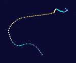
 Season summary map | |
| Seasonal boundaries | |
| First system formed | August 30, 1979 |
| Last system dissipated | March 20, 1980 |
| Strongest storm | |
| Name | Viola-Claudette |
| • Maximum winds | 205 km/h (125 mph) (10-minute sustained) |
| • Lowest pressure | 930 hPa (mbar) |
| Seasonal statistics | |
| Total depressions | 11 |
| Total storms | 11 |
| Tropical cyclones | 4 |
| Intense tropical cyclones | 2 |
| Total fatalities | 30 |
| Total damage | $342 million (1980 USD) |
| Related articles | |
Systems
Summarize
Perspective

Tropical Cyclone Tony
On 26 August, the BoM reported that a tropical low had developed on a shear line about 1300 km (810 mi) to the northwest of Cocos Island.[1] Over the next couple of days the depression gradually developed further before at 1800 UTC on 27 August, TCWC Perth estimated that it had become a tropical cyclone and named it Tony.[1] During the next couple of days, the system moved towards the west-southwest before on 29 August it reached its peak intensity of 95 km/h (60 mph) and a peak pressure of 990 hPa (29.23 inHg) as it approached the edge of TCWC Perth's area of responsibility.[1] During the next day, Tony moved into the South West Indian Ocean and weakened gradually before it dissipated during 31 August.[1] Neither the Mauritius or Reunion meteorological services monitored Tony as a tropical cyclone while it was active, while it was not included in the JTWC's analysis of the season.[1][2][3]
Intense Tropical Cyclone Albine
Albine existed from 25 November to 6 December.
Intense Tropical Cyclone Viola–Claudette
Cyclone Viola entered the basin on December 18 from the Australian region, whereupon it became Cyclone Claudette.[4] After passing southeast of St. Brandon, Claudette struck Mauritius on December 22, producing wind gusts of 221 km/h (137 mph). The storm caused 5 fatalities, 257 injuries, and US$175 million in damage on the island. About 5,000 houses were destroyed or severely damaged. Effects on neighboring Réunion were limited to 79 km/h (49 mph) wind gusts and some rainfall.[5][6][7][8]
Moderate Tropical Storm Berenice
Berenice existed from 15 December to 21 December.
Tropical Depression Wilf–Danitza
Wilf-Danitza existed from 23 December 1979, to 3 January 1980.
Intense Tropical Cyclone Hyacinthe
Hyacinthe formed on January 15, 1980, to the northeast of Mauritius in the southern Indian Ocean. Initially it moved to the west-southwest, and while slowly intensifying it passed north of the French overseas department of Réunion. On January 19, Météo-France estimated that the storm had intensified to a tropical cyclone. Hyacinthe looped to the south of eastern Madagascar and weakened, although it restrengthened after turning to the east. The storm executed another loop to the southwest of Réunion, passing near the island for a second and later third time. Hyacinthe became extratropical on January 29 after turning southward, dissipating two days later.
Tropical Cyclone Hyacinthe set several worldwide tropical cyclone rainfall records in Réunion in the Southwestern Indian Ocean, including a peak total of 5678 mm (223.5 inches).[9] For twelve days, Hyacinthe dropped torrential rainfall on Réunion; nearly all of the island received more than 1 m (3.3 ft) of precipitation. Over a 15‑day period from January 14 to January 28, 6,083 mm (239.5 in) of rainfall were recorded at Commerson's Crater, a volcano. The heaviest rainfall occurred through a process called orographic lift in the mountainous interior, leading to hundreds of landslides. Widespread floods washed out roads and isolated three villages. Hyacinthe caused heavy damage to crops and damaged or destroyed 2,000 houses. Losses from the storm totaled $167 million (1980 USD, 676 million francs), and 25 people were killed.
Intense Tropical Cyclone Jacinthe
Jacinthe existed from 1 February to 7 February. On February 3, the cyclone passed between Mauritius and Rodrigues, producing wind gusts of 117 km/h (73 mph) and 119 km/h (74 mph) on the respective islands.[10]
Severe Tropical Storm Kolia
Kolia existed from 25 February to 13 March. The storm executed two loops near the Mascarene Islands, bringing the storm between Réunion and Mauritius twice. Wind gusts reached 80 km/h (50 mph) on Mauritius.[11]
Intense Tropical Cyclone Laure
Laure existed from 8 March to 17 March. On March 13, the cyclone passed just east of Mauritius, producing wind gusts of 109 km/h (68 mph) and 65.7 mm (2.59 in) of rainfall.[12]
Moderate Tropical Storm 22S
22S existed from 14 March to 20 March.
See also
References
Wikiwand - on
Seamless Wikipedia browsing. On steroids.


