18th Street NW
From Wikipedia, the free encyclopedia
From Wikipedia, the free encyclopedia
18th Street Northwest is a prominent north–south street thoroughfare in the Northwest quadrant of Washington, D.C.
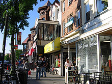
 Shops along 18th Street NW in the Adams Morgan neighborhood | |
| Maintained by | DDOT |
|---|---|
| Length | 2.1 mi (3.4 km)[1] |
| Location | Northwest, Washington, D.C., U.S. |
| South end | |
| Major junctions | Connecticut Avenue in Dupont Circle |
| North end | Columbia Road in Adams Morgan |
| East | 17th Street |
| West | 19th Street |
| Construction | |
| Commissioned | 1791 |

The "18th Street" roadway was part of the 1791 L'Enfant Plan for Washington by Pierre Charles L'Enfant.
In the present day 18th Street also travels through downtown Washington and the Dupont Circle and Mount Pleasant neighborhoods. It is also one of the main streets in the Adams Morgan neighborhood; the other is Columbia Road.
It passes through the Strivers' Section Historic District in the Dupont Circle neighborhood. Many bars, nightclubs, and restaurants are located on 18th Street in Adams Morgan, and on weekends it is frequently congested with cars and pedestrians, especially at last call.[2]

Seamless Wikipedia browsing. On steroids.
Every time you click a link to Wikipedia, Wiktionary or Wikiquote in your browser's search results, it will show the modern Wikiwand interface.
Wikiwand extension is a five stars, simple, with minimum permission required to keep your browsing private, safe and transparent.