Groix
Commune in Brittany, France From Wikipedia, the free encyclopedia
Groix (French pronunciation: [ɡʁwa]; Breton: Enez Groe) is an island and a commune in the Morbihan department of the region of Brittany in north-western France.
Groix
Groe | |
|---|---|
 Aerial view of Groix | |
.svg) Coat of arms | |
Location of Groix  | |
 Groix  Groix | |
| Coordinates: 47°38′22″N 3°27′13″W | |
| Country | France |
| Region | Brittany |
| Department | Morbihan |
| Arrondissement | Lorient |
| Canton | Lorient-2 |
| Intercommunality | Lorient Agglomération |
| Government | |
| • Mayor (2020–2026) | Dominique Yvon[1] |
| Area 1 | 14.82 km2 (5.72 sq mi) |
| Population (2021)[2] | 2,282 |
| • Density | 150/km2 (400/sq mi) |
| Time zone | UTC+01:00 (CET) |
| • Summer (DST) | UTC+02:00 (CEST) |
| INSEE/Postal code | 56069 /56590 |
| Elevation | 0–48 m (0–157 ft) |
| 1 French Land Register data, which excludes lakes, ponds, glaciers > 1 km2 (0.386 sq mi or 247 acres) and river estuaries. | |
Groix lies a few kilometres off the coast of Lorient. Several ferries a day run from Lorient to Groix.
There are a few small towns on the island. High cliffs are on its north coast and sandy beaches in secluded coves on the south coast. Groix is also home to a wide variety of sea birds. Groix is also famous for hosting the only convex beach in Europe, which also moves following sea currents. During the last 15 years, the beach moved half a kilometer westbound.
The geology of Groix is distinct from that of the nearby continent, and the east and south coasts have been designated a mineral nature reserve since 1982.[citation needed] More than 60 minerals can be found on the island, particularly blue glaucophane (observable on the surface), epidote or garnet.[citation needed] The island mainly consists of schist.[citation needed]
A major naval battle between Britain and France took place off Groix in 1795.
The island is the major setting in the fourth book of The Enzo Files - 'Freeze Frame' - by author Peter May.
Climate
| Climate data for Groix (1981–2010 averages) | |||||||||||||
|---|---|---|---|---|---|---|---|---|---|---|---|---|---|
| Month | Jan | Feb | Mar | Apr | May | Jun | Jul | Aug | Sep | Oct | Nov | Dec | Year |
| Record high °C (°F) | 15.4 (59.7) |
16.6 (61.9) |
22.8 (73.0) |
25.8 (78.4) |
29.7 (85.5) |
35.6 (96.1) |
35.3 (95.5) |
35.2 (95.4) |
31.0 (87.8) |
26.5 (79.7) |
19.5 (67.1) |
16.0 (60.8) |
35.6 (96.1) |
| Mean daily maximum °C (°F) | 9.5 (49.1) |
9.5 (49.1) |
11.5 (52.7) |
13.6 (56.5) |
16.6 (61.9) |
19.2 (66.6) |
21.0 (69.8) |
21.3 (70.3) |
19.8 (67.6) |
16.3 (61.3) |
12.7 (54.9) |
10.2 (50.4) |
15.1 (59.2) |
| Mean daily minimum °C (°F) | 5.7 (42.3) |
5.3 (41.5) |
6.8 (44.2) |
7.9 (46.2) |
10.8 (51.4) |
13.3 (55.9) |
15.1 (59.2) |
15.3 (59.5) |
13.8 (56.8) |
11.7 (53.1) |
8.8 (47.8) |
6.4 (43.5) |
10.1 (50.2) |
| Record low °C (°F) | −9.4 (15.1) |
−8.0 (17.6) |
−6.2 (20.8) |
−1.0 (30.2) |
0.4 (32.7) |
5.8 (42.4) |
7.8 (46.0) |
8.4 (47.1) |
7.6 (45.7) |
1.8 (35.2) |
−2.4 (27.7) |
−6.0 (21.2) |
−9.4 (15.1) |
| Average precipitation mm (inches) | 95.7 (3.77) |
70.6 (2.78) |
65.0 (2.56) |
61.3 (2.41) |
59.2 (2.33) |
42.2 (1.66) |
42.7 (1.68) |
39.1 (1.54) |
56.4 (2.22) |
92.3 (3.63) |
91.3 (3.59) |
98.9 (3.89) |
814.7 (32.07) |
| Average relative humidity (%) | 87 | 86 | 85 | 82 | 84 | 83 | 83 | 83 | 83 | 86 | 86 | 88 | 84.7 |
| Source 1: Météo France[3] | |||||||||||||
| Source 2: Infoclimat.fr (humidity, 1961–1990)[4] | |||||||||||||
Population
| Year | Pop. | ±% p.a. |
|---|---|---|
| 1968 | 3,161 | — |
| 1975 | 2,727 | −2.09% |
| 1982 | 2,605 | −0.65% |
| 1990 | 2,472 | −0.65% |
| 1999 | 2,275 | −0.92% |
| 2007 | 2,291 | +0.09% |
| 2012 | 2,223 | −0.60% |
| 2017 | 2,263 | +0.36% |
| Source: INSEE[5] | ||
Inhabitants of Groix are called Groisillons in French.
Gallery
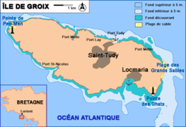 A map of Groix
 Port Tudy, main harbor of Groix


See also
References
Bibliography
External links
Wikiwand in your browser!
Seamless Wikipedia browsing. On steroids.
Every time you click a link to Wikipedia, Wiktionary or Wikiquote in your browser's search results, it will show the modern Wikiwand interface.
Wikiwand extension is a five stars, simple, with minimum permission required to keep your browsing private, safe and transparent.