User:Gazamp/Safekeeping
From Wikipedia, the free encyclopedia
The Andes (/ˈændiːz/ AN-deez), Andes Mountains or Andean Mountain Range (Spanish: Cordillera de los Andes; Quechua: Anti) are the longest continental mountain range in the world, forming a continuous highland along the western edge of South America. The range is 8,900 km (5,530 mi) long and 200 to 700 km (124 to 435 mi) wide (widest between 18°S and 20°S latitude) and has an average height of about 4,000 m (13,123 ft). The Andes extend from north to south through seven South American countries: Venezuela, Colombia, Ecuador, Peru, Bolivia, Chile and Argentina.
| {{{1}}} |
|2=
|2=

Along their length, the Andes are split into several ranges, separated by intermediate depressions. The Andes are the location of several high plateaus—some of which host major cities such as Quito, Bogotá, Cali, Arequipa, Medellín, Bucaramanga, Sucre, Mérida, El Alto and La Paz. The Altiplano Plateau is the world's second-highest after the Tibetan Plateau. These ranges are in turn grouped into three major divisions based on climate: the Tropical Andes, the Dry Andes, and the Wet Andes. (Full article...)
Selected general articles
 Image 1
 Victoria Lagoon
The Sierra Nevada National Park (SNNP) is a National Park of Venezuela located between the states of Mérida and Barinas in western Venezuela. It was created on May 2, 1952, by decree of President Germán Suárez Flamerich, in order to protect the Sierra Nevada de Mérida in the Andes.
It was the second national park decreed, after Henri Pittier National Park, which became the first Venezuelan national park 15 years earlier. (Full article...)- Image 2Cerro Negro de Mayasquer is a volcano on the border of Colombia and Ecuador. It lies 3 kilometres (2 mi) north-west of the volcano Chiles, and the two peaks are considered part of the same Chiles-Cerro Negro volcanic complex. These volcanoes, together with Cumbal are andesitic in rock type. A 1936 eruption reported by the Colombian government agency INGEOMINAS may have been from the Ecuadorean volcano Reventador, otherwise the volcano has not erupted for around 160,000 years. (Full article...)
- Image 3Misti is a dormant volcano located in the Andes mountains in southern Peru, rising above Peru's second-largest city, Arequipa. It is a conical volcano with two nested summit craters, the inner one of which contains a volcanic plug or lava dome with active fumaroles. The summit of the volcano lies on the margin of the outer crater and is 5,822 metres (19,101 ft) above sea level. Snow falls on the summit during the wet season, but does not persist; there are no glaciers. The upper slopes of the volcano are barren, while the lower slopes are covered by bushland.
The volcano developed over four different stages. During each stage, lava flows and lava domes built up a mountain, whose summit then collapsed to form a caldera. The volcano is part of a volcano group with Chachani to the northwest and Pichu Pichu to the southeast, and developed on top of a basement formed by numerous Miocene-Pliocene ignimbrites and volcano-derived debris. Numerous intense explosive eruptions took place during the last 50,000 years and covered the surrounding terrain with tephra. The last two significant eruptions were 2,000 years ago and in 1440–1470 AD; since then, phases of increased fumarolic activity have sometimes been mistaken for eruptions. (Full article...) - Image 4
 Huandoy
Huandoy (probably from Quechua wantuy, to transfer, to transpose, to carry, to carry a heavy load) or Tullparaju (possibly from Quechua tullpa rustic cooking-fire, stove, rahu snow, ice, mountain with snow,) is a mountain located inside Huascarán National Park in Ancash, Peru. It is the second-tallest peak of the Cordillera Blanca section of the Andes, after Huascarán. These two peaks are rather nearby, separated only by the Llanganuco glacial valley (which contains the Llanganuco Lakes) at 3,846 m asl.
It is a snow-capped mountain with four peaks arranged in the form of a fireplace, the tallest of which is 6,395 m. The four peaks are each over 6,000 m, and are:- Huandoy (6,395 m)
- Huandoy-West (6,356 m)
- Huandoy-South (6,160 m)
- Huandoy-East (6,000 m)
- Image 5
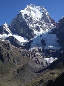 East Face, Yerupajá, May 2006
Yerupajá is a mountain of the Huayhuash mountain range in west central Peru, part of the Andes. It's located at Áncash, Bolognesi Province, Lauricocha Province. At 6,635 metres (21,768 ft) (other sources: 6,617 m (21,709 ft)) it is the second-highest in Peru and the highest in the Huayhuash mountain range. The summit is the highest point in the Amazon River watershed, and was first reached in 1950 by Jim Maxwell and Dave Harrah, and its northern peak (Yerupajá Norte) in 1968 by the Wellingtonian Roger Bates and Graeme Dingle. Many visitors consider Yerupajá to be the most spectacular peak in South America.
There have been only a few successful ascents of the peak because it is one of the hardest Andean high peaks to climb. The most popular route is the southwest face. The approach is normally made from Huaraz southwards via Chiquián and Jahuacocha. (Full article...) - Image 6
 The summit of Chimborazo, the point on the Earth's surface that is farthest from the Earth's center
Chimborazo (Spanish pronunciation: [tʃimboˈɾaso] ⓘ) is an inactive stratovolcano situated in the Cordillera Occidental range of the Andes. Its last known eruption is believed to have occurred around 550 A.D. Although not the tallest mountain in the Andes or on Earth relative to sea level, its summit is the farthest point on Earth's surface from the Earth's center, due to its location along the planet's equatorial bulge. Chimborazo's height is 6,263 m (20,548 ft), well below that of Mount Everest (8,849 m).
Chimborazo is the highest mountain in Ecuador and the 39th highest peak in the entire Andes. It is a popular destination for mountaineering due to its challenging climbing routes, which involve traversing snow, ice, and rocky terrain. (Full article...) - Image 7Pico El Toro is a mountain in the Andes of Venezuela. It has a height of 4755 metres. (Full article...)
- Image 8
The Laguna de Sonso Nature Reserve is located in the Valle del Cauca Department of Colombia. It contains the last extensive remnant of original natural wetland remaining in the Cauca River Valley in western Colombia, and was declared a nature reserve in October 1978. It comprises a series of marshes and lagoons on the east bank of the Cauca River, between the municipalities of Buga, Yotoco and Guacari. It has an area of 2,045 ha (7.90 sq mi), lying at an altitude of 935 m (3,068 ft). The wetlands are affected by the introduced water hyacinth. The reserve has been designated as a protected Ramsar site since 2017. (Full article...) - Image 9
 North face of the Cayambe volcano
Cayambe or Volcán Cayambe is a volcano in Ecuador, in the Cordillera Central, a range of the Ecuadorian Andes. It is located in Pichincha Province, some 70 km (43 mi) northeast of Quito. It is the third-highest mountain in Ecuador, at an elevation of 5,790 m (18,996 ft) above sea level.
Cayambe, which has a permanent snow cap, is a Holocene compound volcano which last erupted in March 1786. At 4,690 metres (15,387 ft), its south slope is the highest point in the world crossed by the Equator, and the only point on the Equator with snow cover. The ice cap covers an area of about 22 km2 (8 sq mi) and there are glaciers on the eastern flank descending to about 4,400 m (14,400 ft), whereas those on the drier western flank reach about 4,700 m (15,400 ft). The volcano and most of its slopes are within the Cayambe Coca Ecological Reserve. (Full article...) - Image 10
 Aerial view of Los Nevados National Park
Los Nevados National Natural Park (Spanish: Parque Nacional Natural Los Nevados) is a national park located in the Cordillera Central of the Colombian Andes. The park surrounds the northern volcanic complex formed by Nevado del Ruiz, Nevado del Tolima, Nevado de Santa Isabel, the paramillos of Cisne, Santa Rosa and Quindío and the Cerro Bravo and Cerro Machín.
The park is located in the departments of Caldas, Quindío, Risaralda, Tolima and spans between the municipalities Manizales, Villamaría, Santa Rosa de Cabal, Pereira, Salento, Villahermosa, Anzoátegui, Santa Isabel, Murillo, Ibagué and Casabianca. (Full article...) - Image 11Paruma is a stratovolcano that lies on the border of Bolivia and Chile. It is part of a ridge that contains several stratovolcanos. Paruma lies at the eastern end of the ridge, with Olca to its west. The older volcano Paruma lies to east of Paruma. Paruma has clearly been active during the Holocene, with many morphologically young lava flows on its flanks. It also has persistent fumaroles. One lava flow in particular extends for 7 kilometres to the south-east of the peak. Historical activity along the ridge has been confined to one eruption from 1865 to 1867, the character of which is not precisely known. (Full article...)
- Image 12
 The Cerro Bayo volcanic complex lies along the Chile-Argentina border east of the Salar de Gorbea, the light-colored area at the left-center portion of this NASA Landsat image. A young well-preserved crater can be seen NE of an older snow-covered center (bottom-center). A younger northern center along the national border has a well-preserved 400-m-wide crater.
Cerro Bayo is a complex volcano on the northern part border between Argentina and Chile. It consists of four overlapping stratovolcanoes along a north–south line. The main volcano face is located on the Argentine side, thought the summit of the complex is just west of the border, in Chile. The volcano is about 800,000 years old, but it is associated with ongoing ground uplift encompassing also the more northerly Lastarria and Cordón del Azufre volcanoes. The 5,401-metre (17,720 ft) high summit is the source of two viscous dacitic lava flows with prominent levees that traveled to the north.
Elemental sulfur can be found at Bayo, both in the form of high-grade massive deposits and as extinct fumarole chimneys. The volcano formed in three separate phases that produced lava flows. One is dated to 1.6±0.4 million years ago. The volcano can bear snow in winter. The youngest dated rocks are about 23,000 years old; in 2007 a steam eruption were observed by researchers investigating nearby salt pans such as Salar Ignorado. (Full article...) - Image 13
 Location of Cerro Maca
Cerro Macá is a stratovolcano located to the north of the Aisén Fjord and to the east of the Moraleda Channel, in the Aysén del General Carlos Ibáñez del Campo Region of Chile. This glacier-covered volcano lies along the regional Liquiñe-Ofqui Fault Zone.
Cerro Macá is a relatively small volcano with a volume of only 39 cubic kilometres (9.4 cu mi). It has a summit elevation of approximately 2,300 m above sea level and features glaciers that in 2011 covered an area of 27.62 square kilometres (10.66 sq mi). The edifice is partially eroded and a sector collapse is probably the origin of a large steep sided depression in the summit area. Pyroclastic cones with associated lava flows are found on its southwestern flank but also on the other slopes of the volcano, as far down as sea level and in the Bahia Aysen. (Full article...) - Image 14
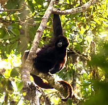
The yellow-tailed woolly monkey (Lagothrix flavicauda) is a New World monkey endemic to Peru. It is a rare primate species found only in the Peruvian Andes, in the departments of Amazonas and San Martin, as well as bordering areas of La Libertad, Huánuco, and Loreto. (Full article...) - Image 15
 View of the range with Yerupajá in the center
Huayhuash (possibly from Quechua waywash, weasel, or waywashi, squirrel) is a mountain range within the Andes of Peru, in the boundaries of the regions of Ancash, Lima and Huánuco. Since 2002 it is protected within the Cordillera Huayhuash Reserved Zone. (Full article...) - Image 16
 Location in Bolivia
Huayna Potosí is a mountain in Bolivia, located near El Alto and about 25 km north of La Paz in the Cordillera Real.
Huayna Potosí is the closest high mountain to La Paz. Surrounded by high mountains, it is roughly 15 miles due north of the city, which makes this mountain the most popular climb in Bolivia. The normal ascent route is a fairly straightforward glacier climb, with some crevasses and a steep climb to the summit. However, the other side of the mountain—Huayna Potosí West Face—is the biggest face in Bolivia. Several difficult snow and ice routes ascend this 1,000-meter-high face. (Full article...) - Image 17
 Location of Sangay in Ecuador
Sangay (also known as Macas, Sanagay, or Sangai) is an active stratovolcano in central Ecuador. It exhibits mostly strombolian activity. Geologically, Sangay marks the southern boundary of the Northern Volcanic Zone, and its position straddling two major pieces of crust accounts for its high level of activity. Sangay's approximately 500,000-year-old history is one of instability; two previous versions of the mountain were destroyed in massive flank collapses, evidence of which still litters its surroundings today.
Due to its remoteness, Sangay hosts a significant biological community with fauna such as the mountain tapir, giant otter, Andean cock-of-the-rock and king vulture. Since 1979, its ecological community has been protected as part of the Sangay National Park. Although climbing the mountain is hampered by its remoteness, poor weather conditions, river flooding, and the danger of falling ejecta, the volcano is regularly climbed, a feat first achieved by Robert T. Moore in 1929. (Full article...) - Image 18
 Road to Mina Julia on Cerro Escorial (1970).
Cerro Escorial is a stratovolcano at the border of Argentina and Chile. It is part of the Corrida de Cori volcanic group and its youngest member. A well-preserved 1-kilometre-wide (0.6 mi) crater forms its summit area. Lava flows are found on the Chilean and smaller ones on the Argentinian side, the former reaching as far as 3–4 kilometres (1.9–2.5 mi) from the volcano. One of these is dated 342,000 years ago by argon-argon dating.
Off the western coast of South America, the Nazca Plate subducts beneath the South America Plate. This process has given rise to the Andes mountain chain and the Altiplano-Puna high plateau, which formed through shortening of the crust that lasted until 1 million years ago. Cerro Escorial rises from the Puna, which is dissected at Cerro Escorial by the Archibarca lineament; it is a strike-slip fault that has facilitated the ascent of magma. (Full article...) - Image 19
 The Marmolejo summit cone sits on the edge of a 4 km (2 mi)-wide collapsed caldera.
Volcán Marmolejo is a 6,108 m (20,039 ft) high Pleistocene stratovolcano in the Andes on the border between Argentina and Chile. It is located 9 km (6 mi) NNE of the active San José volcano, and is the southernmost 6,000 m (19,685 ft)-plus peak in the world. The Argentine portion is within the Argentinean protection area of Provincial Reserve for Multiple Use and Natural Recreation Manzano / Portillo de Piuquenes. It is on the border of two provinces: Argentinean province of Mendoza and Chilean province of Cordillera. Its slopes are within the administrative boundaries of the two cities: Argentinean city of Tunuyán and the Chilean commune of San José de Maipo. (Full article...) - Image 20
 Maipo volcano in 2008
Maipo is a stratovolcano in the Andes, lying on the border between Argentina and Chile. It is located 90 km (56 mi) south of Tupungato and about 100 km (62 mi) southeast of Santiago. It has a symmetrical, conical volcanic shape, and is among the southernmost 5,000 metre peaks in the Andes.
Maipo is located within the Diamante caldera, a feature measuring 15 km by 20 km that is about half a million years old. It rises about 1,900 m (6,230 ft) above the floor of the caldera. Immediately to the east of the peak, on the eastern side of the caldera floor, is Laguna del Diamante, a lake that formed when lava flows blocked drainage channels from the caldera in 1826. The Diamante Caldera erupted 450 cubic kilometers (108 cu mi) of tephra, 450 ka. (Full article...) - Image 21
 Male R. p. sanguinolentus, Colombia
The Andean cock-of-the-rock (Rupicola peruvianus), also known as tunki (Quechua), is a large passerine bird of the cotinga family native to Andean cloud forests in South America. It is the national bird of Peru. It has four subspecies and its closest relative is the Guianan cock-of-the-rock.
The Andean cock-of-the-rock exhibits marked sexual dimorphism; the male has a large disk-like crest and scarlet or brilliant orange plumage, while the female is significantly darker and browner. Gatherings of males compete for breeding females with each male displaying his colourful plumage, bobbing and hopping, and making a variety of calls. After mating, the female makes a nest under a rocky overhang, incubates the eggs, and rears the young by herself. (Full article...) - Image 22
 Located on Argentina/Chile border
Sierra Nevada, also known as Sierra Nevada de Lagunas Bravas, is a major ignimbrite-lava dome complex which lies in both Chile and Argentina in one of the most remote parts of the Central Andes.
Activity in the complex started in Argentina and formed two stratovolcanoes. Later, 12 or more vents formed, some with craters up to 400 metres (1,300 ft) wide. Lava flows up to 7 kilometres (4.3 mi) long with flow ridges are also found. It covers a total area of 225 km2. Radiometric dating has yielded ages of 1.7 ± 0.4 to 0.431 ± 0.012 million years ago, a lava flow from the neighbouring Azufrera Los Cuyanos volcano that is sometimes considered part of Sierra Nevada is 140,000 years old. Together with Cerro el Condor and Peinado it forms the Culampaja line, a line of volcanoes that reaches Cerro Blanco. Strong seismic attenuation is observed beneath Sierra Nevada. Hydrothermally altered rocks in Sierra Nevada may be the source of sulfate and arsenic in the Juncalito and Negro rivers, and heat sources for regional hot springs. The snowline in the area lies at 5,800 metres (19,000 ft) altitude at Cumbre del Laudo. (Full article...) - Image 23
 Vicuña in the Atacama Desert
The vicuña (Lama vicugna) or vicuna (both /vɪˈkuːnjə/, very rarely spelled vicugna, its former genus name) is one of the two wild South American camelids, which live in the high alpine areas of the Andes, the other being the guanaco, which lives at lower elevations. Vicuñas are relatives of the llama, and are now believed to be the wild ancestor of domesticated alpacas, which are raised for their coats. Vicuñas produce small amounts of extremely fine wool, which is very expensive because the animal can only be shorn every three years and has to be caught from the wild. When knitted together, the product of the vicuña's wool is very soft and warm. The Inca valued vicuñas highly for their wool, and it was against the law for anyone but royalty to wear vicuña garments; today, the vicuña is the national animal of Peru and appears on the Peruvian coat of arms.
Both under the rule of the Inca and today, vicuñas have been protected by law, but they were heavily hunted in the intervening period. At the time they were declared endangered in 1974, only about 6,000 animals were left. Today, the vicuña population has recovered to about 350,000, and although conservation organizations have reduced its level of threat classification, they still call for active conservation programs to protect populations from poaching, habitat loss, and other threats. (Full article...) - Image 24

Nevado Sajama ([neˈβaðo saˈxama]; Aymara: Chak Xaña) is an extinct volcano and the highest peak in Bolivia. The mountain is located in Sajama Province, in Oruro Department. It is situated in Sajama National Park and is a composite volcano consisting of a stratovolcano on top of several lava domes. It is not clear when it erupted last but it may have been during the Pleistocene or Holocene.
The mountain is covered by an ice cap, and Polylepis tarapacana trees occur up to 5,000 metres (16,000 ft) elevation. (Full article...) - Image 25
 View of Cardenal Antonio Samoré Pass during winter, latitude 41°S
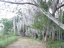
The Wet Andes (Spanish: Andes húmedos) is a climatic and glaciological subregion of the Andes. Together with the Dry Andes it is one of the two subregions of the Argentine and Chilean Andes. The Wet Andes runs from a latitude of 35°S to Cape Horn at 56°S. According to Luis Lliboutry the Wet Andes can be classified after the absence of penitentes. In Argentina well developed penitentes are found as south as on Lanín Volcano (40°S). Another difference is that the Wet Andes is largely devoid of rock glaciers. The glaciers of the Wet Andes have a far more stable line of equilibrium than those of the Dry Andes due to summer precipitations, low thermal oscillations and an overall high moisture. (Full article...)


.jpg)


_male_Antioquia.jpg)


Did you know...
- ... that the 1930s Polish Andean expeditions have been credited with several first ascents and the tracing of a new route to the summit of Aconcagua, the Andes' highest peak?
Need help?
Do you have a question about Andes that you can't find the answer to?
Consider asking it at the Wikipedia reference desk.
Selected images

 Image 2Bolivian Andes (from Andes)


 Image 10Aerial view of Valle Carbajal in the Tierra del Fuego. The Andes range is about 200 km (124 mi) wide throughout its length, except in the Bolivian flexure where it is about 640 kilometres (398 mi) wide. (from Andes)
 Image 12Central Andes (from Andes)
 Image 14Irrigating land in the Peruvian Andes (from Andes)
 Image 15A male Andean cock-of-the-rock, a species found in humid Andean forests and the national bird of Peru (from Andes)

 Image 18Pico Humboldt at sunset (from Andes)

 Image 21Peruvian farmers sowing maize and beans (from Andes)

.jpg)


.jpg)
–Valle_Carbajal_01.jpg)


.jpg)


Subcategories

- Select [►] to view subcategories
Associated Wikimedia
The following Wikimedia Foundation sister projects provide more on this subject:
-
 Commons
Free media repository -
 Wikibooks
Free textbooks and manuals -
 Wikidata
Free knowledge base -
 Wikinews
Free-content news -
 Wikiquote
Collection of quotations -
 Wikisource
Free-content library -
 Wikiversity
Free learning tools -
 Wiktionary
Dictionary and thesaurus
- What are portals?
- List of portals
-->