Timeline of the
2018 Pacific typhoon season |
|---|
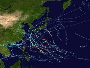 Season summary map | |
| First system formed | December 29, 2017 |
|---|
| Last system dissipated | December 29, 2018 |
|---|
|
| Name | Kong-rey & Yutu |
|---|
| Maximum winds | 215 km/h (130 mph)
(10-minute sustained) |
|---|
| Lowest pressure | 900 hPa (mbar) |
|---|
| |
| Other years
2016, 2017, 2018, 2019, 2020 |
The 2018 Pacific typhoon season was an event in the annual typhoon season in the northwestern Pacific Ocean. The scope of this article is limited to the north of the equator between the 100th meridian east and the 180th meridian. The season had above-average activity, with 29 storms, 13 typhoons, and 7 super typhoons[nb 1] forming within the boundaries of the basin. The season has no official boundaries and storms can form year-round, however most storms typically form between May and November.[2]
The Japan Meteorological Agency (JMA) is the official Regional Specialized Meteorological Centre for the Western Pacific Basin, being responsible for assigning names to all tropical cyclones that reach 10-minute maximum sustained winds of at least 65 kilometres per hour (40 mph).[3] The PAGASA assigns names to tropical cyclones that form or enter their area of responsibility as a tropical depression or stronger.[4] The Joint Typhoon Warning Center (JTWC) also monitors systems in the Western Pacific Basin, assigning systems a number with a "W" suffix.
The 2018 Pacific typhoon season was formerly the costliest Pacific typhoon season on record before being surpassed the following year.
Timeline
January
January 1
January 2
- 02:45 UTC – the system makes its sixth and final landfall on Aborlan.[7]
January 3
January 4
February
February 8
February 10
February 11
- 00:00 UTC at 6.6°N 137.4°E / 6.6; 137.4 – the JTWC upgrades the tropical depression to a tropical storm.[6]
- 06:00 UTC at 6.8°N 135.8°E / 6.8; 135.8 – the JMA upgrades the tropical depression to a tropical storm east of the Palau islands, assigning it the name Sanba, assessing it has peaked in intensity with maximum sustained winds of 65 km/h (40 mph) and a minimum central pressure of 1000 hPa (mbar; 29.59 inHg).[8]
- 12:00 UTC at 7.1°N 134.4°E / 7.1; 134.4 – the JTWC assess that Sanba has peaked in intensity, with 1-minute winds of 75 km/h (45 mph).[6]
- 14:00 UTC at 7.1°N 134.1°E / 7.1; 134.1 – Sanba enters the PAR, prompting the PAGASA to assign it the local name Basyang.[10]
February 13
February 14
February 15
February 16
March
March 24
March 25
March 27
- 00:00 UTC – Jelawat enters the PAR, prompting the PAGASA to assign it the local name Caloy.[13]
- 12:00 UTC – Jelawat exits the PAR.[9]
- 18:00 UTC at 11.2°N 135.4°E / 11.2; 135.4 – the JTWC upgrades Jelawat to a tropical storm.[6]
March 28
March 29
March 30
March 31
May
May 10
May 12
May 13
May 14
May 15
June
June 2
June 3
June 4
June 5
June 6
June 7
June 8
June 9
June 10
- 00:00 UTC at 25.0°N 130.7°E / 25.0; 130.7 – the JMA estimates that Maliksi has peaked in intensity with maximum sustained winds of 110 km/h (70 mph) and a minimum central pressure of 970 hPa (mbar; 28.64 inHg).[8]
June 11
June 13
June 14
June 15
June 16
- 06:00 UTC at 26.8°N 128.9°E / 26.8; 128.9 – the JMA estimates that Gaemi has peaked in intensity with maximum sustained winds of 85 km/h (50 mph) and a minimum central pressure of 990 hPa (mbar; 29.23 inHg).[8]
- 12:00 UTC at 27.2°N 130.8°E / 27.2; 130.8 – the JTWC assesses that Gaemi has transitioned into an extratropical cyclone.[6]
June 17
June 18
- 06:00 UTC – the tropical depression dissipates.[23]
June 21
- 18:00 UTC – Gaemi dissipates.[8]
June 28
June 29
July
July 1
July 2
July 3
July 4
July 5
July 6
July 8
July 9
July 10
July 11
July 13
- 00:00 UTC – Maria dissipates over Central China.[8]
July 14
July 15
July 16
The system made 3 landfalls on Camiguin de Babuyanes, Fuga Island, and Dalupiri Island.[31]
July 17
July 18
Son-Tinh made a fifth landfall on Hà Tĩnh Province.[36]
July 19
July 20
July 21
July 22
Son-Tinh made a sixth landfall on Hainan.[6]
July 23
Son-Tinh made a seventh and and eighth landfall on the Leizhou Peninsula.[6]
July 24
July 25
July 26
July 27
July 28
July 29
July 30
July 31
August
August 1
August 2
August 3
August 4
August 5
August 6
August 7
- 00:00 UTC – the PAGASA upgrades 18W to a tropical depression, assigning it the local name Karding.[51]
- 06:00 UTC at 31.2°N 143.9°E / 31.2; 143.9 – the JTWC upgrades Shanshan to a Category 2-equivalent typhoon on the SSHWS, estimating maximum 1-minute sustained winds of 155 km/h (100 mph).[6]
- 12:00 UTC at 32.0°N 143.1°E / 32.0; 143.1 – the JTWC downgrades Shanshan to a Category 1-equivalent typhoon on the SSHWS.[6]
August 8
August 9
August 10
August 11
August 12
August 13
August 14
August 15
August 16
August 17
August 18
August 19
August 20
August 21
August 22
- 00:00 UTC at 24.2°N 139.9°E / 24.2; 139.9 – the JTWC upgrades Cimaron to a Category 4-equivalent typhoon on the SSHWS, estimating maximum 1-minute sustained winds of 215 km/h (130 mph).[6]
- 00:00 UTC at 22°N 119°E / 22; 119 – the JMA begins tracking a tropical depression in the South China Sea.[57]
- 06:00 UTC at 25.5°N 138.8°E / 25.5; 138.8 – the JMA estimates that Cimaron has peaked in intensity with maximum sustained winds of 155 km/h (100 mph) and a minimum central pressure of 950 hPa (mbar; 28.05 inHg).[8]
- 06:00 UTC at 25.5°N 138.7°E / 25.5; 138.7 – the JTWC downgrades Cimaron to a Category 3-equivalent typhoon on the SSHWS.[6]
- 12:00 UTC at 31.8°N 126.2°E / 31.8; 126.2 – the JTWC downgrades Soulik to a Category 1-equivalent typhoon on the SSHWS.[6]
- 18:00 UTC at 28.4°N 135.9°E / 28.4; 135.9 – the JTWC downgrades Cimaron to a Category 2-equivalent typhoon on the SSHWS.[6]
- 18:00 UTC at 22.3°N 120.0°E / 22.3; 120.0 – the JTWC beings tracking the South China Sea tropical depression, designating it 24W.[6]
- 21:00 UTC – 24W enters the PAR, prompting the PAGASA to assign it the local name Luis.[58]
August 23
August 24
August 25
August 26
August 27
August 28
August 29
August 30
August 31
- 00:00 UTC at 17.9°N 144.2°E / 17.9; 144.2 – the JMA estimates that Jebi has peaked in intensity with maximum sustained winds of 195 km/h (120 mph) and a minimum central pressure of 915 hPa (mbar; 27.02 inHg).[8]
- 06:00 UTC at 18.2°N 142.7°E / 18.2; 142.7 – the JTWC estimates that Jebi has peaked in intensity with maximum 1-minute sustained winds of 285 km/h (180 mph).[6]
September
September 1
September 2
September 3
September 4
September 5
September 6
- 00:00 UTC at 21.2°N 129.2°E / 21.2; 129.2 – the JMA estimates that the Philippine Sea tropical depression has peaked in intensity, with maximum sustained winds of 55 km/h (35 mph) and a minimum central pressure of 1004 hPa (mbar; 29.65 inHg).[71]
- 12:00 UTC at 11.8°N 170.2°E / 11.8; 170.2 – the JMA begins tracking a tropical depression near the Marshall Islands.[8]
September 7
September 8
September 9
September 10
September 11
- 00:00 UTC at 13.9°N 141.2°E / 13.9; 141.2 – the JTWC upgrades Mangkhut to a Category 4-equivalent typhoon on the SSHWS.[6]
- 00:00 UTC at 20.9°N 118.7°E / 20.9; 118.7 – the JMA upgrades 27W to a tropical storm, assigning it the name Barijat.[8]
- 06:00 UTC at 13.9°N 139.8°E / 13.9; 139.8 – the JTWC upgrades Mangkhut to a super typhoon and to a Category 5-equivalent typhoon on the SSHWS.[6]
- 06:00 UTC at 20.7°N 118.0°E / 20.7; 118.0 – the JMA estimates that Barijat has peaked in intensity with maximum sustained winds of 75 km/h (45 mph) and a minimum central pressure of 998 hPa (mbar; 29.47 inHg).[8]
- 06:00 UTC at 20.8°N 118.2°E / 20.8; 118.2 – the JTWC estimates that Barijat has peaked in intensity with maximum 1-minute sustained winds of 85 km/h (50 mph).[6]
- 12:00 UTC at 13.7°N 138.7°E / 13.7; 138.7 – the JMA estimates that Mangkhut has peaked in intensity with maximum sustained winds of 205 km/h (125 mph) and a minimum central pressure of 905 hPa (mbar; 26.72 inHg).[8]
September 12
- 06:00 UTC at 14.0°N 135.2°E / 14.0; 135.2 – the JTWC estimates that Mangkhut has peaked in intensity with maximum 1-minute sustained winds of 285 km/h (180 mph).[6]
- 07:00 UTC – Mangkhut enters the PAR, prompting the PAGASA to assign it the local name Ompong.[75]
September 13
September 14
- 17:30 UTC – Mangkhut makes its first landfall on Baggao.[75]
September 15
September 16
September 17
September 18
- 00:00 UTC – Mangkhut dissipates over Southern China.[8]
September 20
September 21
September 22
September 23
- 02:30 UTC – Trami enters the PAR, prompting the PAGASA to assign it the local name Paeng.[79]
- 06:00 UTC – the International Date Line tropical depression dissipates.[80]
- 06:00 UTC at 17.3°N 134.2°E / 17.3; 134.2 – the JTWC upgrades Trami to a Category 3-equivalent typhoon on the SSHWS.[6]
- 12:00 UTC at 17.5°N 133.3°E / 17.5; 133.3 – the JTWC upgrades Trami to a Category 4-equivalent typhoon on the SSHWS.[6]
September 24
- 06:00 UTC at 18.9°N 130.5°E / 18.9; 130.5 – the JTWC upgrades Trami to a super typhoon.[6]
- 18:00 UTC at 19.6°N 129.1°E / 19.6; 129.1 – the JMA estimates that Trami has peaked in intensity with maximum sustained winds of 195 km/h (120 mph) and a minimum central pressure of 915 hPa (mbar; 27.02 inHg).[8]
- 18:00 UTC at 19.5°N 129.0°E / 19.5; 129.0 – the JTWC upgrades Trami to a Category 5-equivalent typhoon on the SSHWS, estimating maximum 1-minute sustained winds of 260 km/h (160 mph).[6]
September 25
September 26
September 27
September 28
September 29
September 30
October
October 1
October 2
October 3
October 4
October 5
October 6
October 7
- 18:00 UTC – Kong-rey dissipates.[8]
October 19
- 00:00 UTC at 9°N 109°E / 9; 109 – the JMA begins tracking a tropical depression in the South China Sea, estimating a minimum central pressure of 1008 hPa (mbar; 29.77 inHg).[87]
October 20
October 21
October 22
October 23
October 24
October 25
October 26
- 06:00 UTC at 17.0°N 139.1°E / 17.0; 139.1 – the JTWC upgrades Yutu to a Category 5-equivalent typhoon on the SSHWS.[6]
- 22:30 UTC – Yutu enters the PAR, prompting the PAGASA to assign it the local name Rosita.[89]
October 27
October 28
October 29
October 30
October 31
November
November 2
November 3
- 06:00 UTC – Yutu dissipates over the South China Sea.[8]
November 13
November 16
November 17
- 00:00 UTC at 10.0°N 112.5°E / 10.0; 112.5 – the JTWC begins tracking the South China Sea tropical depression, designating it 32W.[6]
- 06:00 UTC at 10.9°N 111.3°E / 10.9; 111.3 – the JMA upgrades 32W to a tropical storm, assigning it the name Toraji and estimating maximum sustained winds of 65 km/h (40 mph) and a minimum central pressure of 1004 hPa (mbar; 29.65 inHg).[8]
- 12:00 UTC at 7.1°N 138.5°E / 7.1; 138.5 – the JTWC begins tracking the Marshall Islands tropical depression, designating it 33W.[6]
- 12:00 UTC at 10.5°N 111.4°E / 10.5; 111.4 – the JTWC estimates that Toraji has peaked in intensity with maximum 1-minute sustained winds of 55 km/h (35 mph).[6]
November 18
- 00:00 UTC at 11.6°N 109.5°E / 11.6; 109.5 – the JMA downgrades Toraji to a tropical depression.[8]
- 02:00 UTC – 33W enters the PAR, prompting the PAGASA to assign it the local name Samuel.[90]
- 12:00 UTC at 12.0°N 107.6°E / 12.0; 107.6 – the JTWC downgrades Toraji to a tropical disturbance.[6]
- 18:00 UTC – the JMA assesses that Toraji has dissipated over Vietnam.[8]
November 20
November 21
November 22
November 23
November 24
- 00:00 UTC at 9.7°N 109.5°E / 9.7; 109.5 – the JMA estimates that Usagi has peaked in intensity with maximum sustained winds of 110 km/h (70 mph) and a minimum central pressure of 990 hPa (mbar; 29.23 inHg).[8]
- 00:00 UTC at 9.6°N 109.5°E / 9.6; 109.5 – the JTWC upgrades Usagi to a Category 2-equivalent typhoon on the SSHWS, estimating maximum sustained winds of 165 km/h (105 mph).[6]
- 02:00 UTC – Man-yi exits the PAR.[92]
- 06:00 UTC at 18.3°N 135.9°E / 18.3; 135.9 – the JTWC downgrades Man-yi to a Category 1-equivalent typhoon on the SSHWS.[6]
- 12:00 UTC at 9.8°N 108.3°E / 9.8; 108.3 – the JTWC downgrades Usagi to a Category 1-equivalent typhoon on the SSHWS.[6]
- 12:00 UTC at 18.7°N 136.2°E / 18.7; 136.2 – the JMA estimates that Man-yi has peaked in intensity with maximum sustained winds of 150 km/h (90 mph) and a minimum central pressure of 960 hPa (mbar; 28.35 inHg).[8]
- 18:00 UTC at 18.5°N 136.1°E / 18.5; 136.1 – the JTWC upgrades Man-yi to a Category 2-equivalent typhoon on the SSHWS.[6]
November 25
November 26
November 27
November 28
November 30
- 12:00 UTC – Man-yi crosses the International Date Line.[8]
December
December 25
- 06:00 UTC at 8°N 135°E / 8; 135 – the JMA begins tracking a tropical depression in the Philippine Sea.[96]
- 07:00 UTC – the Philippine Sea tropical depression enters the PAR, prompting the PAGASA to assign it the local name Usman.[97]
December 27
- 06:00 UTC at 9.9°N 130.9°E / 9.9; 130.9 – the JTWC begins tracking the Philippine Sea tropical depression, designating it 35W.[6]
- 18:00 UTC at 10.7°N 128.4°E / 10.7; 128.4 – the JMA estimates that 35W has peaked in intensity with maximum sustained winds of 55 km/h (35 mph) and a minimum central pressure of 1000 hPa (mbar; 29.53 inHg).[98]
December 28
December 29
- 15:00 UTC – the JMA stops tracking 35W.[99]
December 31
Notes
Super typhoons are an unofficial classification given by the Joint Typhoon Warning Center for storms whose strength are 130 knots (240 km/h; 150 mph) or above.[1] The position is as of 02:00 UTC. The position is as of 19:00 UTC. The position is as of 14:00 UTC. The position is as of 02:00 UTC. The position is as of 07:00 UTC. The position is as of 20:00 UTC.
|


