User:Ɱ/Portal:Columbus, Ohio
From Wikipedia, the free encyclopedia
Portal maintenance status: (October 2021)
|
Introduction

Columbus (/kəˈlʌmbəs/, kə-LUM-bəs) is the capital and most populous city of the U.S. state of Ohio. With a 2020 census population of 905,748, it is the 14th-most populous city in the U.S., the second-most populous city in the Midwest (after only Chicago), and the third-most populous U.S. state capital, after only Phoenix, Arizona and Austin, Texas. Columbus is the seat of government of Franklin County; it also extends into Delaware and Fairfield counties. It is the core city of the Columbus metropolitan area, which encompasses ten counties in central Ohio. It had a population of 2,138,926 in 2020, making it the largest metropolitan area entirely in Ohio and 32nd-largest metro area in the U.S.
Columbus originated as numerous Native American settlements on the banks of the Scioto River. Franklinton, now a city neighborhood, was the first European settlement, laid out in 1797. The city was founded in 1812 at the confluence of the Scioto and Olentangy rivers, and laid out to become the state capital. The city was named for Italian explorer Christopher Columbus. The city assumed the function of state capital in 1816 and county seat in 1824. Amid steady years of growth and industrialization, the city has experienced numerous floods and recessions. Beginning in the 1950s, Columbus began to experience significant growth; it became the largest city in Ohio in land and population by the early 1990s. Growth has continued in the 21st century, with redevelopment occurring in numerous city neighborhoods, including Downtown. (Full article...)
Selected general articles
 Image 1The community of Forest Park consists of almost 2900 private residential properties (single-family homes and duplexes), plus apartments, condominiums, commercial properties, city-owned parks and schools, in approximately 1.4 square miles (3.6 km2) of the Northland area of northeast Columbus, Ohio. These properties adjoin a total of 132 distinct streets and courts maintained by the City of Columbus. The community's approximate center is near the intersection of Karl Road and Sandalwood Place in Columbus. (Full article...)
- Image 2
 High Street in the Short North looking north
High Street is a major thoroughfare in Central Ohio, predominantly in Franklin County and Columbus. It stretches from the northern border of Columbus in Delaware County south to the southern boundary of Franklin County just past Columbus's municipal boundaries. The street is considered one of Columbus's two main roads, along with Broad Street. (Full article...) - Image 3

The Ohio History Center is a history museum and research center in Columbus, Ohio. It is the primary museum for Ohio's history, and is the headquarters, offices, and library of the Ohio History Connection. The building also houses Ohio's state archives, also managed by the Ohio History Connection. The museum is located at the Ohio State Fairgrounds, site of the Ohio State Fair, and a short distance north of downtown. The history center opened in 1970 as the Ohio Historical Center, moving the museum from its former site by the Ohio State University. The building was designed by Ireland & Associates in the Brutalist style. It was listed on the National Register of Historic Places along with the Ohio Village in 2023. (Full article...) - Image 4
 High Street in 2010
Worthington is a city in Franklin County, Ohio, United States, and is a northern suburb of Columbus. The population in the 2020 Census was 14,786. The city was founded in 1803 by the Scioto Company led by James Kilbourne, who was later elected to the United States House of Representatives, and named in honor of Thomas Worthington, who later became governor of Ohio. (Full article...) - Image 5
 Orton Hall
University, Hayes and Orton Halls are three historic buildings on the Oval at the Ohio State University in Columbus, Ohio. On July 16, 1970, they were added to the National Register of Historic Places. The original University Hall was demolished in 1971, and removed from the National Register that year. (Full article...) - Image 6
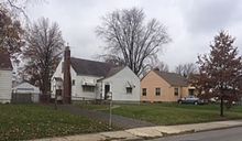
Typical homes in Briggsdale
Briggsdale is a neighborhood of Franklin County in the city of Columbus, Ohio. The neighborhood is on the west/southwest side of the city within the Hilltop area. The area was first settled and founded by the family of Joseph M. Briggs, after whom the neighborhood was named. Joseph Briggs was an active figure in the early years of the township and county operations. The Briggsdale Methodist church was founded with his help, and it now exists as the New Horizons Methodist Church. The present-day Briggsdale neighborhood is located near the historical Green Lawn Cemetery to the north as well as Briggs High School to the west. (Full article...) - Image 7
 West facade of the Ohio Statehouse
The Ohio Statehouse is the state capitol building and seat of government for the U.S. state of Ohio. The Greek Revival building is located on Capitol Square in Downtown Columbus. The capitol houses the Ohio General Assembly, consisting of the House of Representatives and the Senate. It also contains the ceremonial offices of the governor, lieutenant governor, state treasurer, and state auditor. Built between 1839 and 1861, it is one of the oldest working statehouses in the United States. The statehouse grounds include two other buildings, the Judiciary Annex or Senate Building, and the Atrium; the three are collectively referred to as the Ohio Statehouse into the present day.
The statehouse's prominent architecture has earned it several landmark designations, including as a National Historic Landmark. The building sees about 500,000 visitors per year. (Full article...) - Image 8
 Historic home in Harrison West, Ohio
Harrison West is a historic urban neighborhood located northwest of downtown Columbus, Ohio. It sits on several blocks along the Olentangy River and includes the western part of the Near Northside Historic District, which was placed on the National Register of Historic Places in 1975. The character of the neighborhood is similar to Victorian Village, which sits just to the east and is more well-known. (Full article...) - Image 9

King-Lincoln Bronzeville is a historically African American neighborhood in Columbus, Ohio. Originally known as Bronzeville by the residents of the community, it was renamed the King-Lincoln District by Mayor Michael B. Coleman's administration to highlight the historical significance of the district's King Arts Complex and Lincoln Theatre, amid collaborations with investors and developers to revitalize the neighborhood.
In 2009, the King-Lincoln Bronzeville Neighborhood Association asked that the neighborhood be renamed to Bronzeville to reflect its history. (Full article...) - Image 10Trinity Lutheran Seminary at Capital University (formerly the German Theological Seminary of the Ohio Synod; the Evangelical Lutheran Theological Seminary, ELTS; and Trinity Lutheran Seminary) is an Evangelical Lutheran seminary at Capital University in Columbus, Ohio. (Full article...)
- Image 11This is a list of public school buildings in Columbus, Ohio, of historical or architectural importance to the Columbus Public School District. Items are listed by opening date. (Full article...)
- Image 12Georgian Heights is a neighborhood in West Columbus, in Columbus, Ohio, United States. It neighbors Holly Hill. The two are bounded together by Sullivant Avenue on the north, Clime Road on the south, Georgesville Road on the west, and Demorest Road on the east. There is a 10.7 acre public park, Georgian Heights Park, in the center of the area. Georgian Heights has a youth travel football team called the Georgian Heights Packers. The neighborhood is generally lower-middle class. (Full article...)
- Image 13
 Mill Street after the flood, with the tower of Engine House No. 6 in the background
The Great Flood of 1913 severely affected Columbus, Ohio. The area most affected was Franklinton, also known as the Bottoms, for its low elevation near the Scioto River. Among many infrastructure projects, a 7.2-mile floodwall was built from 1993 to 2004 to protect most of Franklinton from flooding.
Columbus historian Ed Lentz described the 1913 flood as "the worst catastrophe in the history of Columbus". (Full article...) - Image 14
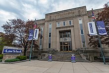
Capital University Law School is an ABA-accredited private law school located in downtown Columbus, Ohio, United States. The law school is affiliated with Capital University, the oldest university in Central Ohio and one of the oldest and largest Lutheran-affiliated universities in North America. (Full article...) - Image 15Milo-Grogan is a neighborhood of Columbus, Ohio. The neighborhood was settled as the separate communities of Milo and Grogan in the late 1870s. Large-scale industrial development fueled the neighborhood's growth until the 1980s, when the last factories closed. The community has received urban renewal efforts in recent years fueled by the Columbus Department of Development and Milo-Grogan Area Commission. (Full article...)
- Image 16
 Broad Street over the Discovery Bridge heading east into downtown
Broad Street is a major thoroughfare in Central Ohio, predominantly in Franklin County and Columbus. It stretches east from West Jefferson at Little Darby Creek to Pataskala. The street is considered one of Columbus's two main roads, along with High Street.
Broad Street was first laid out around 1797, when Franklinton was settled. In 1812, when Columbus was founded, a new section of the street was built in the new city. The street first connected to the rest of the settled country in 1831, when the Ohio and Erie Canal reached Columbus. In 1833, the National Road was extended to Columbus, utilizing all of West Broad Street. In the mid-to-late 19th century, East Broad Street became a fashionable place for wealthy homeowners, and large mansions were built along the tree-lined street. Large hotels and apartments followed into the early 1900s. The street has seen numerous changes since then, including clearing and widening. Portions of the street were improved with trees, bike lanes, and rainwater basins in Franklinton, with additional streetscape improvements planned for other sections of the street. (Full article...) - Image 17
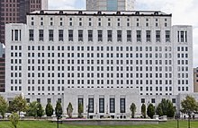
The Thomas J. Moyer Ohio Judicial Center is a state courthouse, office building, and library in Columbus, Ohio, in the city's downtown Civic Center. The building is the headquarters of the Supreme Court of Ohio, the state's highest court, as well as the Ohio Court of Claims and Ohio Judicial Conference. The judicial center is named after the court's former chief justice Thomas J. Moyer.
The building was designed by Harry Hake in the Art Deco style. It was built from 1930 to 1933, known as the Ohio Departments Building, as it first housed Ohio state departments. The building was added to the National Register of Historic Places in 1990. Beginning in 2001, an extensive renovation restored the building, and set it up to be used for the Supreme Court of Ohio. The building reopened in 2004, marking the first time the court was established in a building solely for the judiciary, and the first time the building was open to the public. (Full article...) - Image 18Blacklick Estates is a census-designated place (CDP) in Franklin County, Ohio, United States: partly in Madison Township and partly in Truro Township. As of the 2020 census the population was 8,990. (Full article...)
- Image 19

Columbus Museum of Art at The Pizzuti is a museum for contemporary art in Columbus, Ohio, United States. It has been part of the Columbus Museum of Art since September 2018. The three-story gallery is located in the Short North and Victorian Village neighborhoods, on the eastern edge of Goodale Park. Its exhibits rotate, featuring artists from around the world.
The museum was originally owned by the Pizzuti family, which made its wealth from the real estate firm the Pizzuti Companies. The family began collecting art in 1977, after a trip to Paris. The Pizzuti Collection opened in 2013, and had shown 16 temporary exhibits before its 2018 donation to the Columbus Museum of Art. (Full article...) - Image 20

Huntington Center in downtown Columbus
Columbus, Ohio has a generally strong and diverse economy based on education, insurance, banking, fashion, defense, aviation, food, logistics, steel, energy, medical research, health care, hospitality, retail, and technology.
Prominent employers in the Columbus area include numerous schools (e.g., The Ohio State University) and hospitals, hi-tech research and development and information/library companies such as Battelle Memorial Institute, OCLC, and Chemical Abstracts, and retail clothing and restaurant companies (such as Limited Brands and Wendy's). Other large employers include Alliance Data, Nationwide Insurance, JP Morgan Chase, American Electric Power, Huntington Bancshares, Worthington Industries and Cardinal Health, not to mention both state and local government. (Full article...) - Image 21The University District (or University Area), is a 2.8-square-mile (7.3 km2) area located 2 miles (3.2 km) north of Downtown Columbus, Ohio that is home to the main campus of Ohio State University, the Battelle Institute, and Wexner Medical Center. It is generally accepted as the area bounded to the north by Clintonville at Glen Echo Ravine; to the south by the Short North at 5th Avenue; to the west by the Olentangy River and to east by the Conrail railroad tracks. Points of interest include, but are not limited to, the Ohio Stadium and Old North Columbus. The district is Columbus' most densely populated area and contains more than 650 businesses, human service agencies, churches, and schools. University District businesses include boutiques, mixed retail, several tattoo studios, the Gateway Film Center, and a diverse range of restaurants and bars. (Full article...)
- Image 22
 The Palace Theatre and LeVeque Tower
The Palace Theatre is a 2,695-seat restored movie palace located at 34 W. Broad Street in Columbus, Ohio. It was designed and built in 1926 by the American architect Thomas W. Lamb as part of the American Insurance Union Citadel (now the LeVeque Tower). Today the theater functions as a multi-use performing arts venue. It is owned and operated by The Columbus Association for the Performing Arts. The Palace Theater's "house" is considered separate from LeVeque Tower, while the marquee and lobby are part of the LeVeque complex. (Full article...) - Image 23

The James A. Rhodes State Office Tower is a 41-story, 629-foot (192 m) state office building and skyscraper on Capitol Square in Downtown Columbus, Ohio. The Rhodes Tower is the tallest building in Columbus and the fifth tallest in Ohio. The tower is named for James A. Rhodes, the longest-serving Ohio governor, and features a statue of Rhodes outside the entrance. The building's interior includes a large open lobby with 22 elevators. Higher floors have offices for numerous state agencies. The tower's 40th floor contains an observation deck, open to the public.
The Rhodes Tower was designed by Brubaker/Brandt and Dalton, Dalton, Little, and Newport in a Modernist style. It was conceived in 1969 as a way to consolidate state offices in one building and give more space to legislative offices in the Ohio Statehouse. Construction spanned from 1971 to 1974; it has held state offices since mid-1974, including the Supreme Court of Ohio until it moved to the renovated Ohio Judicial Center in 2004. The Rhodes Tower was renovated from 2018 to 2022 for energy savings and façade maintenance. (Full article...) - Image 24
 The Macon Hotel
Mount Vernon is a predominantly African-American historic neighborhood in Columbus, Ohio, United States. The neighborhood lies within the historic Near East Side community, north of King-Lincoln Bronzeville. Mount Vernon borders Interstates 71 and 670. Its main thoroughfares, Mount Vernon Avenue, Long Street, Atcheson Street, and Champion Avenue define the community's limits.
The neighborhood is named for Mount Vernon Avenue, the center of a once-thriving economy. In the 19th century into the 1970s, the area (including the present-day King-Lincoln Bronzeville) held thousands of Black families and businesses, with a variety of businesses lining the avenue. It was during an era of segregation and isolation for the community, and thus Black families were self-sustaining in the area. Beginning in the 1950s, interstate highways were constructed in Columbus. The highways physically divided parts of the neighborhood and their large land uses forced families and businesses to relocate, leading to more vacancies and an overall neighborhood decline.
The Leonard Pearl Henderson House in the neighborhood is a historically-significant house near an Ohio State University medical center. The building was proposed for demolition in 2023. (Full article...) - Image 25

The Billy Ireland Cartoon Library & Museum is a research library of American cartoons and comic art affiliated with the Ohio State University library system in Columbus, Ohio. Formerly known as the Cartoon Research Library and the Cartoon Library & Museum, it holds the world's largest and most comprehensive academic research facility documenting and displaying original and printed comic strips, editorial cartoons, and cartoon art. The museum is named after the Ohio cartoonist Billy Ireland.
Covering comic books, daily strips, Sunday strips, editorial cartoons, graphic novels, magazine cartoons, and sports cartoons, the collection includes 450,000 original cartoons, 36,000 books, 51,000 serial titles, and 3,000 feet (910 m) of manuscript materials, plus 2.5 million comic strip clippings and tear sheets. (Full article...)


Need help?
Do you have a question about Columbus, Ohio that you can't find the answer to?
Consider asking it at the Wikipedia reference desk.
Selected images
 Image 2Racial distribution in Columbus in 2010: ⬤ White ⬤ Black ⬤ Asian ⬤ Hispanic ⬤ Other (from Columbus, Ohio)
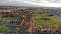 Image 3Lou Berliner Sports Park (from List of parks in Columbus, Ohio)
 Image 4Eastern side of Olentangy Commons (from Neighborhoods in Columbus, Ohio)
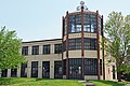
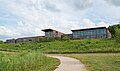 Image 6Audubon nature center at Scioto Audubon Metro Park, the first built close to a major city's downtown (from Columbus, Ohio)
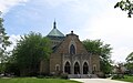 Image 7St. Mary Magdalene Church in Westgate (from Neighborhoods in Columbus, Ohio)
 Image 9Municipal offices, including the Columbus Division of Police Headquarters, in the city's Civic Center (from Columbus, Ohio)
 Image 10Bird's eye view map of Columbus in 1872 (from Columbus, Ohio)


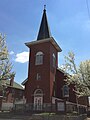 Image 14Hungarian Reform Church, in Hungarian Village (from Neighborhoods in Columbus, Ohio)
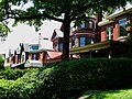 Image 15Victorian-style homes located along Goodale Park (from Neighborhoods in Columbus, Ohio)


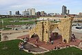
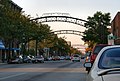 Image 22The iconic arches of the Short North (from Neighborhoods in Columbus, Ohio)
 Image 23Map of land surveys and city boundary growth, 1812–1920 (from History of Columbus, Ohio)
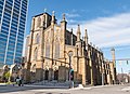
 Image 25The Scioto Mile includes nine parks along both banks of the Scioto River between downtown Columbus and Franklinton. (from Columbus, Ohio)
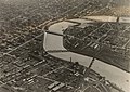 Image 27The city c. 1924 (from History of Columbus, Ohio)
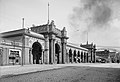

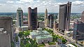 Image 30Four of the city's five tallest buildings are around Capitol Square (from List of tallest buildings in Columbus, Ohio)
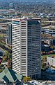
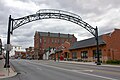 Image 32Old North Columbus Arch (from Neighborhoods in Columbus, Ohio)
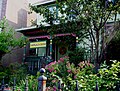 Image 33Historic Home in Harrison West (from Neighborhoods in Columbus, Ohio)

 Image 37Barlouie (from Neighborhoods in Columbus, Ohio)
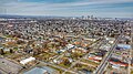 Image 39Aerial view of Reeb-Hosack (from Neighborhoods in Columbus, Ohio)
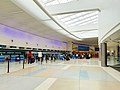
 Image 41Big Run Sports Complex, in Big Run Park (from Neighborhoods in Columbus, Ohio)
 Image 42The Columbus Museum of Art collects and exhibits American and European modern and contemporary art, folk art, glass art, and photography. (from Columbus, Ohio)
 Image 44Dutch Colonial Style residences in Hungarian Village (from Neighborhoods in Columbus, Ohio)
- Image 462010 Census-based map: red dots indicate white Americans, blue dots for African Americans, green for Asian Americans, orange for Hispanic Americans, yellow for other races. Each dot represents 25 residents. (from Neighborhoods in Columbus, Ohio)
 Image 47COSI (east entrance pictured) features themed, interactive science exhibits. (from Columbus, Ohio)
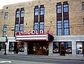 Image 48The historic Lincoln Theatre (from Neighborhoods in Columbus, Ohio)
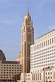 Image 49The LeVeque Tower was the tallest building in Columbus from 1927 to 1973. (from List of tallest buildings in Columbus, Ohio)
 Image 50Map of the Ohio Country between 1775 and 1794, depicting locations of battles and massacres surrounding the area that would eventually become Ohio (from History of Columbus, Ohio)
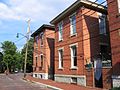 Image 51Homes in German Village (from Neighborhoods in Columbus, Ohio)
 Image 52The Santa Maria Ship & Museum, a Santa María replica, was docked downtown from 1991 to 2014. (from Columbus, Ohio)

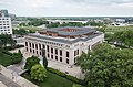
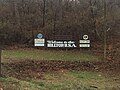 Image 56Hilltop signage (from Neighborhoods in Columbus, Ohio)
 Image 57Locations of numbered streets and avenues (from Columbus, Ohio)
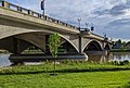
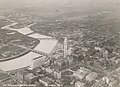 Image 59The city in 1936 (from Columbus, Ohio)
 Image 60I-71, part of the innerbelt around downtown, bridged by numerous overpasses (from Columbus, Ohio)
 Image 61Skyline of Columbus (Use cursor to identify buildings) (from List of tallest buildings in Columbus, Ohio)
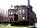 Image 62Home in Old Oaks (from Neighborhoods in Columbus, Ohio)
 Image 63The Merion Village arch (from Neighborhoods in Columbus, Ohio)
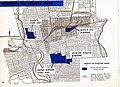 Image 641954 urban renewal map of Columbus (from List of demolished buildings and structures in Columbus, Ohio)
- Image 65Bird's eye view map of Columbus in 1872 (from History of Columbus, Ohio)
- Image 69Map of the Ohio Country between 1775 and 1794, depicting locations of battles and massacres surrounding the area that would eventually become the U.S. state of Ohio (from Columbus, Ohio)


- Image 72Columbus in 1936 (from History of Columbus, Ohio)
 Image 74Aerial satellite image of Columbus (from Columbus, Ohio)
 Image 78Brewery District Scene (from Neighborhoods in Columbus, Ohio)
 Image 79The Pontifical College Josephinum (1888-1931) (from List of demolished buildings and structures in Columbus, Ohio)
 Image 80Holy Rosary and Saint John Church (from Neighborhoods in Columbus, Ohio)
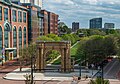 Image 82Located in the Arena District, McFerson Commons is home to the Union Station arch. (from Columbus, Ohio)
 Image 84Ohio Stadium, on the campus of Ohio State University, is the 5th-largest non-racing stadium in the world. (from Columbus, Ohio)
 Image 86Arcade of the third Union Station, the city's rail station from 1897 to 1977 (from Columbus, Ohio)
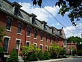 Image 88Italian Village rowhouse (from Neighborhoods in Columbus, Ohio)
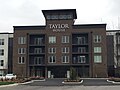 Image 90Taylor House on Bethel Rd. (from Neighborhoods in Columbus, Ohio)
 Image 91Camp Chase as it stands today, a memorial to fallen soldiers from the American Civil War. (from Neighborhoods in Columbus, Ohio)

.png)


.jpg)

_-_exterior_2.jpg)


.jpg)


.jpg)
.jpg)


_crop.jpg)


.jpg)


Subcategories

- Select [►] to view subcategories
Subtopics
Associated Wikimedia
The following Wikimedia Foundation sister projects provide more on this subject:
-
 Commons
Free media repository -
 Wikibooks
Free textbooks and manuals -
 Wikidata
Free knowledge base -
 Wikinews
Free-content news -
 Wikiquote
Collection of quotations -
 Wikisource
Free-content library -
 Wikiversity
Free learning tools -
 Wiktionary
Dictionary and thesaurus
- What are portals?
- List of portals
Category:United States portals by city Category:Portals needing placement of incoming links