Uryū, Hokkaido
Town in Hokkaido, Japan From Wikipedia, the free encyclopedia
Uryū (雨竜町, Uryū-chō) is a town located in Sorachi Subprefecture, Hokkaido, Japan.
This article needs additional citations for verification. (October 2022) |
Uryū
雨竜町 | |
|---|---|
Town | |
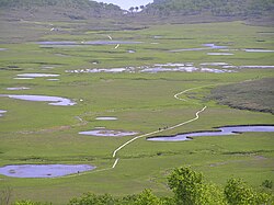
 Uryunuma Wetland | |
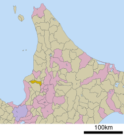
 Location of Uryū in Hokkaido (Sorachi Subprefecture) | |
| Coordinates: 43°39′N 141°53′E | |
| Country | Japan |
| Region | Hokkaido |
| Prefecture | Hokkaido (Sorachi Subprefecture) |
| District | Uryū |
| Area | |
| • Total | 190.91 km2 (73.71 sq mi) |
| Population (October 1, 2020) | |
| • Total | 2,389 |
| • Density | 13/km2 (32/sq mi) |
| Time zone | UTC+09:00 (JST) |
| Website | www |
As of 1 October 2020, the town has an estimated population of 2,389, and a density of 12.5 persons per km2. The total area is 190.91 square kilometres (73.71 sq mi).[1]
Etymology
The name of the town is from the Ainu language, but the origin of name has been lost. Urir-o-pet, one possibility, means "cormorant river".[1]
In Japanese, the name of the town is written with ateji, or kanji characters used to phonetically represent native or borrowed words. The first, 雨, means "rain", and the second, 竜, means "dragon".
Neighboring municipalities
- Rumoi Subprefecture
- Sorachi Subprefecture
References
External links
Wikiwand in your browser!
Seamless Wikipedia browsing. On steroids.
Every time you click a link to Wikipedia, Wiktionary or Wikiquote in your browser's search results, it will show the modern Wikiwand interface.
Wikiwand extension is a five stars, simple, with minimum permission required to keep your browsing private, safe and transparent.


