Tukey's Bridge
Bridge in Maine, United States From Wikipedia, the free encyclopedia
Bridge in Maine, United States From Wikipedia, the free encyclopedia
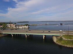
Tukey's Bridge is a bridge connecting the neighborhoods of Munjoy Hill and East Deering in Portland, Maine. It is part of Interstate 295, U.S. Route 1, and Washington Avenue (State Route 26).
Tukey's Bridge | |
|---|---|
 Tukey's Bridge from the west, above Back Cove | |
| Coordinates | 43°40′35″N 70°15′23″W |
| Carries | Eight auto lanes; |
| Crosses | Back Cove |
| Locale | Portland, Maine |
| History | |
| Opened | 1960 |
| Location | |
 | |
Back Cove Trail crosses the bridge on its western side.
Several bridges by the same name have existed connecting the areas.[1][2] The current bridge was completed in 1960 and named for Lemuel Tukey, a tavern owner and tax collector from the Back Cove area of Portland in the late 18th century.[3] It replaced a bridge completed around 1898, and which carried the Portland and Yarmouth Electric Railway.[4]
Seamless Wikipedia browsing. On steroids.
Every time you click a link to Wikipedia, Wiktionary or Wikiquote in your browser's search results, it will show the modern Wikiwand interface.
Wikiwand extension is a five stars, simple, with minimum permission required to keep your browsing private, safe and transparent.