Trenggalek Regency (Indonesian: Kabupaten Trenggalek; Javanese: ꦏꦧꦸꦥꦠꦺꦤ꧀ꦠꦿꦼꦁꦒꦭꦺꦏ꧀) is a regency (kabupaten) in East Java, Indonesia.
Trenggalek ꦠꦿꦼꦁꦒꦭꦺꦏ꧀ | |
|---|---|
 Hill | |
 Coat of arms | |
| Motto(s): Jwalita Praja Karana ꦗ꧀ꦮꦭꦶꦠꦥꦿꦗꦏꦫꦤ (Brilliant because of the people) | |
 Trenggalek ꦠꦿꦼꦁꦒꦭꦺꦏ꧀ Location of Trenggalek in Indonesia | |
| Coordinates: 8°03′S 111°43′E | |
| Country | |
| Province | East Java |
| Government | |
| • Regent | M. Nur Arifin[1] |
| Area | |
| • Total | 1,261.40 km2 (487.03 sq mi) |
| Elevation | 110 m (360 ft) |
| Highest elevation | 2,563 m (8,409 ft) |
| Lowest elevation | 0 m (0 ft) |
| Population (mid 2023 estimate)[3] | |
| • Total | 756,109 |
| • Density | 600/km2 (1,600/sq mi) |
| Time zone | UTC+7 |
| Website | trenggalekkab.go.id |
This regency has an area of 1,261.40 km2 and had a population of 674,411 residents at the 2010 Census[4] and 731,125 at the 2020 Census;[5] the official estimate as of mid-2023 was 756,109.[3] It is located on the southern shore of East Java and is surrounded by three regencies: Ponorogo Regency to the northwest; Pacitan Regency to the southwest; and Tulungagung Regency to the east. The administrative centre is located in the district (kecamatan) of Trenggalek.
Geography
Trenggalek is a regency that is located on the southern shore of Java island and has the following geographical boundaries:
- To the northwest: Ponorogo Regency;
- To the southwest: Pacitan Regency;
- To the east: Tulungagung Regency;
- To the south: Indian Ocean, and
- To the north: Mount Wilis.
Administrative districts
The Regency is divided into fourteen districts (kecamatan), tabulated below with their areas and their population totals from the 2010 Census[4] and the 2020 Census,[5] together with the official estimates as of mid-2023.[3] The table also includes the locations of the district headquarters, the number of administrative villages in each district (totaling 152 rural desa and 5 urban kelurahan - the latter all in Trenggalek (town) District), and its postal codes.
| Kode Wilayah | Name of District (kecamatan) | Area in km2 | Pop'n Census 2010 | Pop'n Census 2020 | Pop'n Estimate mid 2023 | Admin centre | No. of villages | Post codes |
|---|---|---|---|---|---|---|---|---|
| 35.03.01 | Panggul (a) | 131.56 | 69,325 | 78,344 | 81,492 | Wonocoyo | 17 | 66364 |
| 35.03.02 | Munjungan (b) | 154.80 | 46,916 | 52,908 | 54,498 | Munjungan | 11 | 66365 |
| 35.03.08 | Watulimo (c) | 154.44 | 62,625 | 70,002 | 72,855 | Prigi | 12 | 66382 |
| 35.03.07 | Kampak | 79.00 | 35,743 | 37,201 | 38,453 | Bendoagung | 7 | 66373 |
| 35.03.04 | Dongko | 141.20 | 59,248 | 65,505 | 68,272 | Dongko | 10 | 66363 |
| 35.03.03 | Pule | 118.12 | 50,908 | 55,822 | 57,843 | Pule | 10 | 66362 |
| 35.03.06 | Karangan | 50.92 | 45,432 | 49,930 | 50,853 | Karangan | 12 | 66361 |
| 35.03.14 | Suruh | 50.72 | 24,546 | 26,028 | 26,795 | Suruh | 7 | 66360 |
| 35.03.10 | Gandusari | 54.96 | 49,082 | 52,560 | 54,167 | Gandusari | 11 | 66372 |
| 35.03.13 | Durenan | 57.16 | 48,985 | 51,320 | 51,917 | Kendalrejo | 14 | 66381 |
| 35.03.12 | Pogalan | 41.80 | 47,951 | 52,234 | 53,737 | Ngadirenggo | 10 | 66371 |
| 35.03.11 | Trenggalek (town) | 61.16 | 62,606 | 64,306 | 66,887 | Ngantru | 15 (d) | 66311 - 66319 |
| 35.03.05 | Tugu | 74.72 | 45,764 | 47,829 | 49,749 | Gondang | 15 | 66352 (e) |
| 35.03.09 | Bendungan | 90.84 | 25,280 | 27,136 | 28,591 | Dompyong | 8 | 66351 |
| Totals | 1,261,40 | 674,411 | 731,125 | 756,109 | 157 |
Notes: (a) including 11 small offshore islands. (b) including 23 small offshore islands. (c) including 23 small offshore islands.
(d) comprising 5 urban kelurahan (Kelutan, Ngantru, Sumbergedong, Surodakan and Tamanan) and 10 desa.
(e) except for the village of Banaran, which has a post code of 66318.
Commodities

Agricultural produce in the area includes rice, corn, cassava, soya beans,and legumes.[citation needed] Plantations produce sugar cane, cloves, durians, salak, mangosteens, and rambutans. Industrial outputs include soy sauce, syrup, tapioca, anchovies, batik, snacks, cigarettes, sawmill, building materials, roofs, and tofu.[citation needed]
Tourism and cultural sights
Trenggalek has several tourist sites, including beaches (Pantai), caves, and mountain ranges.[6][7]

- Gua Lowo is a cave with examples of stalactites and stalagmites. Based on a cave expert, Mr. Gilbert Manthovani and Dr. Robert K. Kho in 1984, it was declared that Guo Lowo is the biggest natural cave in Southeast Asia with approximately 800 meters of length, nine main rooms, and some small rooms. Guo Lowo means "bat cave", owing to the many bats living here when it was first discovered.[8]
- Pantai Prigi. This beach is known for its rock formations.[citation needed] There is also a fish market and a harbor.[9]
- Pantai Pasir Putih. Means "white sand beach" and is located adjacent to the Prigi beach.
- Pantai Pelang. This beach has a waterfall and some tiny islands.[citation needed]
- Larung Sembonyo. This traditional ceremony is held annually.
- Pemandian Tapan. This bathing place is located in Karangan and the natural water source comes directly from the mountain ranges.[citation needed]
- Upacara Dam Bagong. The bull's head is swept away in Kali Bagong (Bagong river) in this annually-held ceremony.
- Candi Brongkah. It is a temple that tells the history of Trenggalek.[citation needed]
- Alun-alun Kota. It is the central park in the middle of the city. It also has a playground and snack vendors nearby.[citation needed]
- Tri Turonggo Yakso. It is a typical traditional dance of Trenggalek. The dance belongs to the traditional dance called "jaranan" which also founded another region. Turonggo Yakso symbolizes the victory of villages in driving away from the devil.[citation needed]
Gallery
 A view over Pucanganak village in western Trenggalek
 Traditional boats are popular among tourists on Prigi beach
 Sunset on Prigi pier
 Skyline of Trenggalek Kota
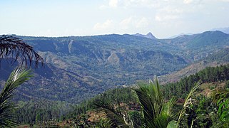 Highlands in western Trenggalek
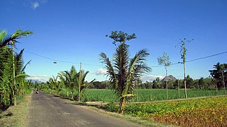 Plantations in a typical village
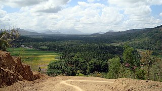
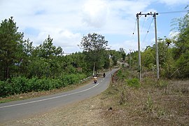 Winding road to Bendungan district in northern Trenggalek
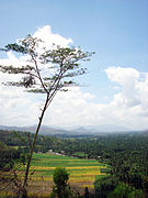 Village in Trenggalek


See also
References
Wikiwand in your browser!
Seamless Wikipedia browsing. On steroids.
Every time you click a link to Wikipedia, Wiktionary or Wikiquote in your browser's search results, it will show the modern Wikiwand interface.
Wikiwand extension is a five stars, simple, with minimum permission required to keep your browsing private, safe and transparent.