Tago District, Gunma
Former district in Gunma prefecture, Japan From Wikipedia, the free encyclopedia
Tago District (多胡郡, Tago-gun) was formerly a rural district located in Gunma Prefecture, Japan. Parts of the modern cities of Takasaki and Fujioka were formerly within the district.

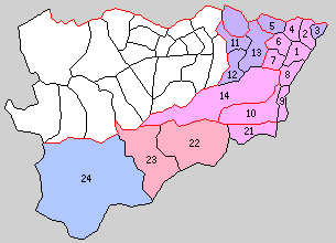
1. Fujioka, 2. Kanna, 3. Shin, 4. Ono, 5. Yawata, 6. Midori, 7. Hirai, 8. Mikuri, 9. Onishi, 10. Sanbagawa, 11.Yoshii, 12.Tago, 13. Irino, 14. Hino, 21. Mihara, 22. Kamikawa, 23. Nakasato, 24. Ueno: areas 11 through 14 were formerly Midono District
Tago District was the name of one of the ancient districts of Kōzuke Province, mentioned in the Shoku Nihongi of 711 AD. Modern Tago District was created on December 7, 1878, with the reorganization of Gunma Prefecture into districts. It included 19 villages, which were formerly part of the tenryō holdings in Kōzuke Province administered directly by the Tokugawa shogunate, seven villages that were part of the holdings of Yoshii Domain and three villages which were part of the holdings of Obama Domain. With the establishment of the municipalities system on April 1, 1889, the area was organized as one town (Yoshii) and three villages.
On April 1, 1896, the district was merged with Minamikanra and Midono to form Tano District.

Wikiwand in your browser!
Seamless Wikipedia browsing. On steroids.
Every time you click a link to Wikipedia, Wiktionary or Wikiquote in your browser's search results, it will show the modern Wikiwand interface.
Wikiwand extension is a five stars, simple, with minimum permission required to keep your browsing private, safe and transparent.
