
Taconic Mountains
Appalachian Mountain range in the United States / From Wikipedia, the free encyclopedia
Dear Wikiwand AI, let's keep it short by simply answering these key questions:
Can you list the top facts and stats about Taconic Range?
Summarize this article for a 10 year old
The Taconic Mountains (/təˈkɒnɪk/) are a 150-mile-long sub-range of the Appalachian Mountains lying on the eastern border of New York State and adjacent New England. The range, which played a role in the history of geological science, is separated from the Berkshires and Green Mountains to the east by a series of valleys, principally those of the Housatonic River, Battenkill River and Otter Creek. The Taconics' highest point is Mount Equinox in Vermont at 3,840 feet (1,170 m); among many other summits are Dorset Mountain, Mount Greylock and Mount Everett.[1][2][3]
| Taconic Mountains | |
|---|---|
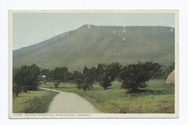 Mount Equinox (3,840 ft) in Vermont is the high point of the Taconic range | |
| Highest point | |
| Peak | Equinox Mountain, Bennington County, Vermont |
| Elevation | 3,850 ft (1,170 m) |
| Geography | |
 Orogenies of the northeast United States
| |
| Country | United States |
| State | New York, Connecticut, Massachusetts, Vermont |
| Region | western New England, eastern New York |
| Range coordinates | 42°41.5′N 73°17.1′W |
| Parent range | Appalachian Mountains |
| Biome | Northern hardwood forest, |
| Geology | |
| Orogeny | Taconic Orogeny |
| Age of rock | 440 million years |
| Type of rock | Thrust fault |
Forests are predominately maple-beech-birch with some spruce-fir at higher elevations, "and oak and hickory common to the south and at lower elevations."[4] Parts of the Taconics are in the New England-Acadian forests ecoregion.[5] Although mostly private property, the Taconics contain a half-dozen sizable state forests and parks, as well as many preserves of lesser acreage protected by land trusts.[6][7][8][9][10] Several hundred miles of trails are within these mountains, including parts of the Appalachian Trail.