Southern Peninsula (Iceland)
Region of Iceland From Wikipedia, the free encyclopedia
Southern Peninsula (Icelandic: Suðurnes, Icelandic pronunciation: [ˈsʏːðʏrˌnɛːs] ) is an administrative unit and part of Reykjanesskagi (pronounced [ˈreiːcaˌnɛsˌskaijɪ]), or Reykjanes Peninsula, a region in southwest Iceland. It was named after Reykjanes, the southwestern tip of Reykjanesskagi.[1]
Suðurnes | |
|---|---|
 The Suðurnes area | |
| Coordinates: 63°55′N 22°15′W | |
| Country | Iceland |
| Seat | Keflavík |
| Area | |
| • Total | 829 km2 (320 sq mi) |
| Population (2020) | |
| • Total | 27,829 |
| • Density | 24.5/km2 (63/sq mi) |
| ISO 3166 code | IS-2 |

The region has a population of 27,829 (2020) and is one of the more densely populated parts of the island. The administrative centre is Keflavík, which had 7,000 residents when it merged with the nearby town of Njarðvík and Hafnir in 1995 to create Reykjanesbær, which is the largest settlement outside the Greater Reykjavík area; in 2018 the region had a population of 17,805.[2] The region is the location of Keflavík International Airport, the major point of entry for Iceland.[3][4] Some fishing towns, such as Grindavík, Njarðvík and Sandgerði, are situated on the peninsula.
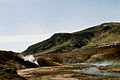
The peninsula is marked by active volcanism under its surface and large lava fields, allowing little vegetation. There are numerous hot springs in the southern half of the peninsula, around the Kleifarvatn lake and the Krýsuvík geothermal area.[5] There is a geothermal power station at Svartsengi. Near the power station a luxury spa and pool area has been installed using the hot and mineralized water coming down from the power station; it is known as the "Blue Lagoon" (Bláa Lónið).[6]
The Bridge Between Continents spans the Álfagjá [ˈaulvaˌcauː] rift valley (60 feet (18 m) wide and 20 feet (6.1 m) deep) near Grindavík, which is promoted to tourists as marking the boundary between the Eurasian and North American tectonic plates. It was built in 2002 and previously named Leif the Lucky bridge in honor of Icelandic explorer Leif Eriksson who traveled from Europe to America nearly 500 years before Christopher Columbus.[7]
A great deal of volcanic unrest was occurring in this part of the Reykjanes Peninsula from 2020 onward, after nearly 800 years of inactivity. After the eruption of the Fagradalsfjall volcano started on 19 March 2021,[8] National Geographic's experts predicted that this "may mark the start of decades of volcanic activity". The eruption was small, leading to a prediction that this volcano was unlikely to threaten "any population centers".[9] In November 2023, a new bout of seismic activity occurred around Grindavík, prompting the town's evacuation and the declaration of a state of emergency over the threat of an imminent volcanic eruption,[10] culminating in the 2023-2024 Sundhnúkur eruptions.
Reykjanes volcanic belt
| Reykjanes volcanic belt | |
|---|---|
,_Reykjanes_peninsula.JPG) The Reykjanes volcanic belt is almost completely covered by lava fields. | |
| Highest point | |
| Coordinates | 63°52′12″N 22°33′30″W |
| Geography | |
 Map of volcanic systems on the Reykjanes Peninsula. 1) Reykjanes, 2) Svartsengi, 3) Fagradalsfjall, 4) Krýsuvík, 5) Brennisteinsfjöll, and 6) Hengill | |
| Location | Reykjanes Peninsula, Iceland |
| Parent range | Mid-Atlantic Ridge |
| Geology | |
| Mountain type | fissure |
| Last eruption | 2023 CE[11] |
The Southern Peninisula contains the south western portion of the Reykjanes volcanic belt, where the continuation of the Mid-Atlantic Ridge and its submarine Reykjanes Ridge with the transitional Eldey volcanic system, rise above sea level. The Reykjanes volcanic belt has between 3 and 6 volcanic systems (depending on author -see map for 6 system on land classification of the Reykjanes, Svartsengi, Fagradalsfjall, Krýsuvík, Brennisteinsfjöll, and Hengill volcanic systems). These are closely spaced en-echelon fissure systems, extending across the Reykjanes Peninsula.[12][13][14][15]). Each volcanic system on the peninsula consists of (volcanic and tectonic) fissures and faults directed mostly NE-SW and may have other features such as lava fields and postglacial basaltic crater rows. Only the Hengill volcanic system, the most eastern system, has an additional central volcano, but this is outside the Southern Peninsula.[16][17] Tephra deposits from offshore explosive Holocene eruptions have been preserved on the Reykjanes Peninsula.[13]
Gallery
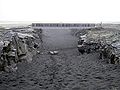 Leif the Lucky Bridge spanning the Álfagjá rift valley
 Reykjanesvirkjun geothermal power plant
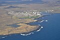
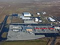 Keflavík International Airport
 Litli-Hrútur eruption 2023. View from an airplane


,_Grindavík.JPG)


See also
References
External links
Wikiwand in your browser!
Seamless Wikipedia browsing. On steroids.
Every time you click a link to Wikipedia, Wiktionary or Wikiquote in your browser's search results, it will show the modern Wikiwand interface.
Wikiwand extension is a five stars, simple, with minimum permission required to keep your browsing private, safe and transparent.