Sakaraha (district)
Place in Atsimo-Andrefana, Madagascar From Wikipedia, the free encyclopedia
Sakaraha is a district located in Atsimo-Andrefana Region, south-western Madagascar.
Sakaraha | |
|---|---|
 | |
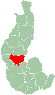
 Map of former Toliara Province showing the location of Sakaraha (red). | |
| Country | Madagascar |
| Region | Atsimo-Andrefana |
Communes
The district is further divided into 11 communes:
Geography
Sakaraha is situated along route nationale No. 7 (Tuléar-Fianarantsoa) at 134 km from Tuléar, 64 km from Andranovory and 84 km from Ilakaka.[1] Zombitse-Vohibasia National Park is located in the district, east of the town of Sakaraha. Analavelona Massif is in the western portion of the district.
References
Wikiwand in your browser!
Seamless Wikipedia browsing. On steroids.
Every time you click a link to Wikipedia, Wiktionary or Wikiquote in your browser's search results, it will show the modern Wikiwand interface.
Wikiwand extension is a five stars, simple, with minimum permission required to keep your browsing private, safe and transparent.

