
Saint-Georges-de-Luzençon
Commune in Occitanie, France / From Wikipedia, the free encyclopedia
Dear Wikiwand AI, let's keep it short by simply answering these key questions:
Can you list the top facts and stats about Saint-Georges-de-Luzençon?
Summarize this article for a 10 year old
SHOW ALL QUESTIONS
Saint-Georges-de-Luzençon (French pronunciation: [sɛ̃ ʒɔʁʒ də lyzɑ̃sɔ̃]; Occitan: Sent Jòrdi) is a commune in the Aveyron department in southern France. The commune was part of the Rouergue province, where people communicated with a variation of the Occitan language, Rouergat.
You can help expand this article with text translated from the corresponding article in French. (December 2008) Click [show] for important translation instructions.
|
Quick Facts Country, Region ...
Saint-Georges-de-Luzençon | |
|---|---|
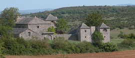 Les Brouzes | |
 Coat of arms | |
Location of Saint-Georges-de-Luzençon  | |
 Saint-Georges-de-Luzençon  Saint-Georges-de-Luzençon | |
| Coordinates: 44°03′55″N 2°59′11″E | |
| Country | France |
| Region | Occitania |
| Department | Aveyron |
| Arrondissement | Millau |
| Canton | Millau-1 |
| Intercommunality | Millau Grands Causses |
| Government | |
| • Mayor (2020–2026) | Didier Cadaux[1] |
| Area 1 | 47.73 km2 (18.43 sq mi) |
| Population (2021)[2] | 1,595 |
| • Density | 33/km2 (87/sq mi) |
| Time zone | UTC+01:00 (CET) |
| • Summer (DST) | UTC+02:00 (CEST) |
| INSEE/Postal code | 12225 /12100 |
| Elevation | 340–782 m (1,115–2,566 ft) (avg. 356 m or 1,168 ft) |
| 1 French Land Register data, which excludes lakes, ponds, glaciers > 1 km2 (0.386 sq mi or 247 acres) and river estuaries. | |
Close