Puerto Rico Highway 506 (PR-506) is a two-lane tertiary highway in the municipality of Ponce in Puerto Rico. The road runs north to south, joining PR-14, where PR-506 starts, to PR-52 interchange, where it ends. The road is located entirely within Barrio Coto Laurel and its length is 2.0 km (1.2 mi).[3]
 Highway 506 | ||||
|---|---|---|---|---|
| Ruta 506 | ||||
| Carretera Doctor Humberto Zayas Chardón[1] | ||||
.svg) | ||||
| Route information | ||||
| Maintained by Puerto Rico DTPW | ||||
| Length | 2.0 km[2] (1.2 mi) | |||
| Major junctions | ||||
| South end | Urbanización Hacienda Juliana in Coto Laurel | |||
| North end | ||||
| Location | ||||
| Country | United States | |||
| Territory | Puerto Rico | |||
| Municipalities | Ponce | |||
| Highway system | ||||
| ||||
| ||||
Route description
In its short 2.0 km (1.2 mi) length, PR-506 is home to Hospital San Cristóbal, Bolera Caribe, National University College, a pharmacy, a branch of the United States Post Office, a bank, and many restaurants, among other businesses and few neighborhoods located in Barrio Coto Laurel. The southern end of PR-506 also provides access to Industrias Vassallo[4] and Cristalia Premium Water[5][6] industries.
 Puerto Rico Highway 506 is also called Carretera Dr. Humberto Zayas Chardón (Dr. Humberto Zayas Chardón Road)
 National University College seen from Puerto Rico Highway 506
,_Bo._Coto_Laurel,_Ponce,_Puerto_Rico,_mirando_al_sur_(DSC03539).jpg)
.jpg)
History
Until 2012 the road ran south to north starting at the easternmost edge of Mercedita International Airport at PR-1 and Camino Buyones, heading north and intersecting with PR-52 and continuing north to intersect with PR-14 where it ended. In that year, however, the Government of Puerto Rico abandoned maintenance of the stretch of the road from its PR-1 intersection to its intersection with PR-52, and the road was signed only from PR-52 to PR-14. At that time, the road was longer than its current 2.0 km (1.2 mi).
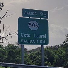 PR-52 south approaching exit 95 to PR-506 in Barrio Coto Laurel
 Puerto Rico Highway 506 heading north from Autopista Luis A. Ferré (PR-52)

.jpg)
Major intersections
The entire route is located in Coto Laurel, Ponce.
| km[2] | mi | Destinations | Notes | ||
|---|---|---|---|---|---|
| 2.0 | 1.2 | Southern terminus of PR-506 at Urbanización Hacienda Juliana | |||
| 1.6– 1.5 | 0.99– 0.93 | Diamond interchange; PR-52 (unsigned PRI-1) exit 95 | |||
| 0.0 | 0.0 | PR-14 – Ponce, Juana Díaz | Northern terminus of PR-506; unsigned | ||
| 1.000 mi = 1.609 km; 1.000 km = 0.621 mi | |||||
Related route
Puerto Rico Highway 5506 (PR-5506) is an important tributary of PR-506. This is a two-lane tertiary road which intersects with PR-1 and the southern terminus of PR-10, an important primary highway.[8] The entire route is located in Ponce.
 Counterclockwise terminus of PR-5506 in Barrio Sabanetas
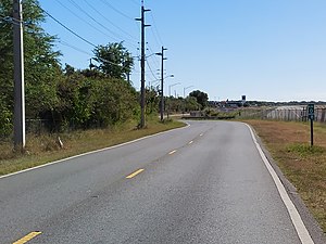 PR-5506 in Barrio Sabanetas
.jpg)
.jpg)
| Location | km[7] | mi | Destinations | Notes | |
|---|---|---|---|---|---|
| Vayas–Sabanetas line | 0.0 | 0.0 | Clockwise terminus of PR-5506 | ||
| 1.4 | 0.87 | Counterclockwise terminus of PR-5506 and southern terminus of PR-10; PR-52 access is via PR-10; PR-52 exit 98B | |||
| Aeropuerto Mercedita (Avenida Aeropuerto), Central Mercedita (Calle La Esperanza) | |||||
| 1.000 mi = 1.609 km; 1.000 km = 0.621 mi | |||||
See also
References
External links
Wikiwand in your browser!
Seamless Wikipedia browsing. On steroids.
Every time you click a link to Wikipedia, Wiktionary or Wikiquote in your browser's search results, it will show the modern Wikiwand interface.
Wikiwand extension is a five stars, simple, with minimum permission required to keep your browsing private, safe and transparent.