Portal:East Sussex
Wikipedia portal for content related to East Sussex / From Wikipedia, the free encyclopedia
Portal maintenance status: (June 2018)
|

East Sussex is a ceremonial county in South East England. It is bordered by Kent to the north-east, West Sussex to the west, Surrey to the north-west, and the English Channel to the south. The largest settlement is the city of Brighton and Hove, and the county town is Lewes.
The county has an area of 1,792 km2 (692 sq mi) and a population of 822,947. The latter is largely concentrated along the coast, where the largest settlements are located: Brighton and Hove (277,105), Eastbourne (99,180), and Hastings (91,490). The centre and north of the county are largely rural, and the largest settlement is Crowborough (21,990). For local government purposes, East Sussex comprises a non-metropolitan county, with five districts, and the unitary authority of Brighton and Hove. East Sussex and West Sussex historically formed a single county, Sussex.
East Sussex is part of the historic county of Sussex, which has its roots in the ancient kingdom of the South Saxons, who established themselves there in the 5th century AD, after the departure of the Romans. Archaeological remains are plentiful, especially in the upland areas. The area's position on the coast has also meant that there were many invaders, including the Romans and later the Normans, following the defeat of the English army by William the Conquerer at the Battle of Hastings in 1066. Earlier industries included fishing, iron-making, and the wool trade, all of which have declined or been lost completely. (Full article...)
Selected article

Hastings (/ˈheɪstɪŋz/ HAY-stings) is a seaside town and borough in East Sussex on the south coast of England, 24 mi (39 km) east of Lewes and 53 mi (85 km) south east of London. The town gives its name to the Battle of Hastings, which took place 8 mi (13 km) to the north-west at Senlac Hill in 1066. It later became one of the medieval Cinque Ports. In the 19th century, it was a popular seaside resort, as the railway allowed tourists and visitors to reach the town. Today, Hastings is a fishing port with the UK's largest beach-based fishing fleet. It has an estimated population of 91,100 as of 2021. (Full article...)
Selected images
 Image 1 (from Portal:East Sussex/Selected pictures)
 Image 2 (from Portal:East Sussex/Selected pictures)
 Image 3Beachy Head and lighthouse, Eastbourne, East Sussex (from Portal:East Sussex/Selected pictures)
 Image 4Credit: Ian Dunster(from Portal:East Sussex/Selected pictures)
Looking up at the East Hill Cliff Railway in Hastings, the steepest funicular railway in the country. Image 5 (from Portal:East Sussex/Selected pictures)
 Image 6 (from Portal:East Sussex/Selected pictures)
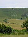 Image 7 (from Portal:East Sussex/Selected pictures)
 Image 8 (from Portal:East Sussex/Selected pictures)

 Image 11Mermaid Street in Rye showing typically steep slope and cobbled surface (from Portal:East Sussex/Selected pictures)
 Image 12 . (from Portal:East Sussex/Selected pictures)
Oct2005.jpg)


Selected biography
_2008.06.20_009.jpg)
Graham McPherson (born 13 January 1961), known primarily by his stage name Suggs, is an English singer-songwriter, musician, radio personality and actor.
In a music career spanning 40 years, he came to prominence in the late 1970s as the lead singer of the ska band Madness, which released fifteen singles that entered the top 10 charts in the United Kingdom during the 1970s, 1980s and 1990s, including "My Girl", "Baggy Trousers", "Embarrassment", "It Must Be Love", "House of Fun", "Driving in My Car", "Our House", "Wings of a Dove" and "Lovestruck". Suggs began his solo career in 1995, while still a member of Madness. Since then, he has released two studio albums and two compilation albums. His solo hits include "I'm Only Sleeping", "Camden Town", "Cecilia" and "Blue Day".
Suggs has also been an actor, with roles in films, theatre and television. He is married and is the father of two children. (Full article...)
Did you know that

General images - load new batch
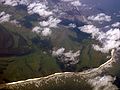 Image 1Aerial view of Beachy Head, with Eastbourne visible at the top of the photo. (from Beachy Head)
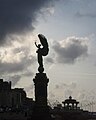 Image 2The Peace Statue on the seafront marks the border between Brighton and Hove (from Brighton and Hove)
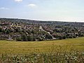 Image 3Happy Valley, Woodingdean (from Brighton and Hove)
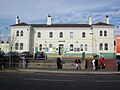 Image 4Portslade Station (from Brighton and Hove)
 Image 5Stanmer Village (from Brighton and Hove)
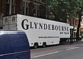 Image 6The Glyndebourne on Tour trailer (from Glyndebourne Festival Opera)
 Image 7Sheepcote Valley (from Brighton and Hove)
 Image 8Brighton and Hove downland and seafront (from Brighton and Hove)
 Image 9Northward view along Warmdene Road, Patcham (from Brighton and Hove)
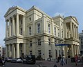 Image 10Brighton Town Hall at Bartholomews in The Lanes (from Brighton and Hove)
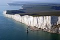
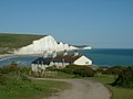
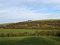 Image 14Varncombe Hill (from Brighton and Hove)
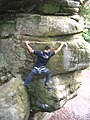 Image 15Climber enjoying the Lower Cretaceous Ashdown Bed Sandstones of High Rocks (from Geology of East Sussex)
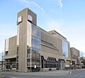 Image 16Hove Town Hall on Church Road (from Brighton and Hove)
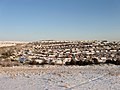 Image 17Hangleton in the snow (from Brighton and Hove)
 Image 18St Wulfran, Ovingdean (from Brighton and Hove)
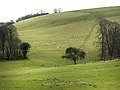 Image 19Sheep on Tegdown Hill (from Brighton and Hove)
 Image 20View from Hollingbury Hill, Brighton (from Brighton and Hove)
 Image 21Bevendean Down (Local Nature Reserve) (from Brighton and Hove)
 Image 22Sweet Hill, near Patcham, Brighton, The old farm house (from Brighton and Hove)
 Image 23Population pyramid of Brighton and Hove in 2021 (from Brighton and Hove)
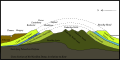 Image 24Geological section from north to south (from Geology of East Sussex)
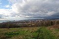 Image 25Westward view across Brighton from Whitehawk Hill (from Brighton and Hove)
 Image 26Cross section view of Southern England featuring the Weald Basin (from Geology of East Sussex)
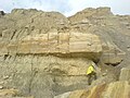 Image 27A geologist studies the Ashdown Formation on the East Sussex coast (from Geology of East Sussex)
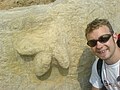
 Image 29Footpath towards Moulsecoomb Wild Park (from Brighton and Hove)
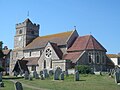 Image 30St Leonard's Church, in the town centre, has 11th-century origins. (from Seaford, East Sussex)
 Image 31Bridleway, Falmer Hill (from Brighton and Hove)
 Image 32Trigpoint on the approach to Mount Zion (from Brighton and Hove)
 Image 33Cockroost Bottom (from Brighton and Hove)
 Image 34The council is currently composed of 38 Labour, 7 Green, 6 Conservative and 3 independent councillors (from Brighton and Hove)
 Image 35Geology of south-eastern England. The Ashdown Sands and Wadhurst Clay is in lime green (9a); the Low Weald, darker green (9). Chalk Downs, pale green (6) (from Geology of East Sussex)
 Image 36This painting by F.H. Varley depicts a WWI training exercise in Seaford. Soldiers emerge from a gas hut wearing gas masks. (from Seaford, East Sussex)
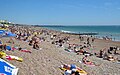 Image 37Brighton beach (from Brighton and Hove)
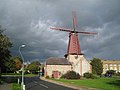 Image 38West Blatchington windmill (from Brighton and Hove)
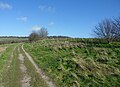 Image 39Southwestward view along Ladies Mile, Patcham (from Brighton and Hove)
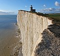
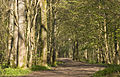 Image 41Stanmer Park (from Brighton and Hove)
 Image 42Electricity Pylons on Cockroost Hill (from Brighton and Hove)
 Image 43Glyndebourne House, 1 August 2006 (from Glyndebourne Festival Opera)
 Image 44Track at The Bostle (from Brighton and Hove)
 Image 46Ewe Bottom from the Sussex Border Path (from Brighton and Hove)
 Image 47Seaford Beach with Seaford Head in the background. (from Seaford, East Sussex)
 Image 48Northeastward view along Hollingbury Crescent, Hollingdean (from Brighton and Hove)
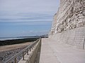 Image 49Undercliff path East of Brighton (from Brighton and Hove)
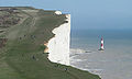 Image 50Looking towards the cliffs and lighthouse from the west near Birling Gap. (from Beachy Head)
 Image 51Chattri Brighton from the West (from Brighton and Hove)
 Image 521–14 Chichester Terrace, Kemp Town (from Brighton and Hove)
 Image 53The Patcham Pylons mark the border of Brighton and Hove on the A23 (from Brighton and Hove)


_(April_2013).JPG)


.JPG)
_(July_2014)_(1).jpg)
.jpg)
.jpg)


_(2).JPG)


_(10).JPG)
,_Bevendean_(May_2020)_(6).JPG)


_(1).JPG)


.jpg)


.JPG)


.jpg)
_(2).JPG)


_(September_2018)_(2).jpg)
,_Patcham_(from_SW).jpg)
List articles

- List of hills of East Sussex
- List of local nature reserves in East Sussex
- List of monastic houses in East Sussex
- List of museums in East Sussex
- List of Parliamentary constituencies in East Sussex
- List of places in East Sussex
- List of settlements in East Sussex by population
- List of Sites of Special Scientific Interest in East Sussex
- List of windmills in East Sussex
Subcategories

Settlements map

Things you can do
- Add to this portal.
- Join the Sussex WikiProject
Topics
Related portals
Associated Wikimedia
The following Wikimedia Foundation sister projects provide more on this subject:
-
 Commons
Free media repository -
 Wikibooks
Free textbooks and manuals -
 Wikidata
Free knowledge base -
 Wikinews
Free-content news -
 Wikiquote
Collection of quotations -
 Wikisource
Free-content library -
 Wikiversity
Free learning tools -
 Wikivoyage
Free travel guide -
 Wiktionary
Dictionary and thesaurus


