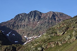
Pica d'Estats
Mountain in the country of Spain From Wikipedia, the free encyclopedia
Mountain in the country of Spain From Wikipedia, the free encyclopedia
Pica d'Estats (or The States Peak) (Catalan: Pica d'Estats, French: Pique d'Estats) is a 3,143-metre-high (10,312 ft) mountain in the Montcalm Massif, Pyrenees.[1] on the Spanish–French border, and is the highest mountain in Catalonia.
| Pica d'Estats | |
|---|---|
| Pic d'Estats | |
 | |
| Highest point | |
| Elevation | 3,143 m (10,312 ft) |
| Prominence | 1,277 m (4,190 ft) |
| Coordinates | 42°40′02″N 01°23′50″E |
| Geography | |
| Location | Pallars Sobirà, Catalonia, Spain Ariège, Occitania, France |
| Parent range | Pyrenees |
| Climbing | |
| First ascent | 1864 by Henry Russell and Jean-Jacques Denjean |
This mountain is included in the Parc Natural de l'Alt Pirineu.

The summit is located between the Catalan municipality of Alins in Pallars Sobirà and the French district of Ariège. It comprises three peaks, all lying close to each other:
This eastern peak is the geodesic vertex. The ridge runs north-northwest to southeast along the Spanish–French border.
Seamless Wikipedia browsing. On steroids.
Every time you click a link to Wikipedia, Wiktionary or Wikiquote in your browser's search results, it will show the modern Wikiwand interface.
Wikiwand extension is a five stars, simple, with minimum permission required to keep your browsing private, safe and transparent.