Puerto Rico Highway 163 (PR-163) is a major two-way thoroughfare in Ponce, Puerto Rico. The road has both of its termini as well as all of its length entirely within the Ponce city limits. The road runs east to west from its eastern terminus at PR-2 in Barrio San Antón to its western terminus at PR-500 in Barrio Canas. The road has a length of 4.8 kilometers.[3] Most of the road runs as part of Avenida Las Américas.
 Highway 163 | ||||
|---|---|---|---|---|
| Ruta 163 | ||||
.svg) | ||||
| Route information | ||||
| Maintained by Puerto Rico DTPW | ||||
| Length | 4.5 km[1] (2.8 mi) | |||
| Existed | 1960[2]: 52 –present | |||
| Major junctions | ||||
| West end | ||||
| East end | ||||
| Location | ||||
| Country | United States | |||
| Territory | Puerto Rico | |||
| Municipalities | Ponce | |||
| Highway system | ||||
| ||||
Route description
The two-way roadway is 4.8 kilometers long, starts at PR-2 in Barrio San Antón and runs westward. The road is named "Avenida Julio Enrique Monagas" from kilometer 0.0 at PR-2, in the western end of Barrio San Antón, to kilometer 0.7 in central Barrio San Antón, where it then starts to run over Avenida Las Américas. It then runs its next 4.1 kilometers over Avenida Las Américas until its western terminus at its junction with PR-500 in Barrio Canas. The road's run on Avenida Julio Enrique Monagas is a divided 4-lane roadway; its run over Avenida Las Américas is as a divided 6-lane roadway. Its western terminus with PR-500 is near Puente San Antonio.[2]: 251
Starting at PR-2 in Barrio San Antón, PR-163 runs westerly. From there, the road's first major intersection is at kilometer 0.7 with Avenida Las Américas. Heading west, PR-163's next major intersection is with Avenida Santiago de los Caballeros, also known as "Avenida Malecón" (PR-12). Continuing west from PR-12, the road crosses over Río Portugués before passing by Hospital Metropolitano Dr. Pila. It then intersects with Avenida Hostos (PR-123) in Barrio Canas, after which it passes by Museo de Arte de Ponce on the right[4] and Pontifical Catholic University of Puerto Rico,[5] on the left. Its next major intersection is with PR-2R (Ramal PR-2) at Secretaría de Recreación y Deportes Francisco "Pancho" Coimbre, near Francisco Montaner Stadium and Juan Pachín Vicéns Auditorium. About 1 kilometer after this, the road comes to its end at its junction with PR-500 in Barrio Canas.
 PR-163 looking east near PR-2R in Barrio Canas Urbano, Ponce, Puerto Rico
 Hospital Dr. Pila (now, Hospital Metropolitano Dr. Pila) on the north side of Avenida Las Américas (PR-163) looking northeast, in Barrio Canas Urbano
.jpg)
_looking_NE_in_Barrio_Canas_Urbano,_Ponce,_Puerto_Rico_(IMG_2739).jpg)
Characteristics
The less transited western section of this road experiences an hourly traffic flow upwards of 2400 vehicles.[6] On the westernmost end of the road, Puente San Antonio connects the road with PR-9, also called Avenida Baramaya.[2]: 251
Major intersections
The entire route is located in Ponce.
 PR-12 north near its exit to PR-163 (Avenida Las Américas)
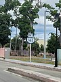 PR-123 north approaching PR-163 (Avenida Las Américas) junction
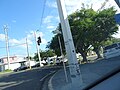 Avenida Eduardo Ruberté Bisó at PR-163 (Avenida Las Américas) junction
.jpg)

_y_Av._Eduardo_Ruberté_(PR-585),_Bo._Canas_Urbano,_Ponce,_PR,_mirando_al_noreste_(DSC04249).jpg)
| Location | km[1] | mi | Destinations | Notes | |
|---|---|---|---|---|---|
| Canas Urbano | 4.5 | 2.8 | Western terminus of PR-163 | ||
| 3.8 | 2.4 | Avenida Eduardo Ruberté Bisó | |||
| 3.3 | 2.1 | ||||
| 2.5 | 1.6 | Avenida Luis Muñoz Rivera / Calle Capitán Correa | |||
| 1.6 | 0.99 | ||||
| San Antón | 0.85– 0.75 | 0.53– 0.47 | Diamond interchange | ||
| 0.65 | 0.40 | Avenida Las Américas / Avenida Julio Enrique Monagas / Calle Marzo Cabrera | Eastern terminus of PR-163 through Bulevar Luis A. Ferré (Avenida Las Américas) and western terminus of PR-163 through Avenida Julio Enrique Monagas | ||
| 0.0 | 0.0 | Eastern terminus of PR-163 | |||
1.000 mi = 1.609 km; 1.000 km = 0.621 mi
| |||||
See also
References
External links
Wikiwand in your browser!
Seamless Wikipedia browsing. On steroids.
Every time you click a link to Wikipedia, Wiktionary or Wikiquote in your browser's search results, it will show the modern Wikiwand interface.
Wikiwand extension is a five stars, simple, with minimum permission required to keep your browsing private, safe and transparent.