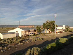
Oasis, Nevada
Census-designated place in Nevada, United States From Wikipedia, the free encyclopedia
Census-designated place in Nevada, United States From Wikipedia, the free encyclopedia
Oasis is a census-designated place (CDP) located in eastern Elko County, Nevada, United States,[1] at the junction of State Route 233 and Interstate 80, 31 miles (50 km) northwest of the Utah border and 77 miles (124 km) east of Elko. As of the 2008 American Community Survey it had a population of 34. As of 2020, Oasis had a population of just four.[3]
Oasis, Nevada | |
|---|---|
 | |
| Coordinates: 41°01′43″N 114°28′35″W[1] | |
| Country | United States |
| State | Nevada |
| County | Elko |
| Area | |
| • Total | 0.89 sq mi (2.31 km2) |
| • Land | 0.89 sq mi (2.31 km2) |
| • Water | 0.00 sq mi (0.00 km2) |
| Elevation | 5,843 ft (1,781 m) |
| Population (2020) | |
| • Total | 4 |
| • Density | 4.48/sq mi (1.73/km2) |
| Time zone | UTC-8 (Pacific (PST)) |
| • Summer (DST) | UTC-7 (PDT) |
| ZIP code | 89835 |
| Area code | 775 |
| FIPS code | 32-52200 |
| GNIS feature ID | 2583946[1] |
Oasis is a high desert community located in the Goshute Valley between the Pequop Mountains and the Toano Range at an elevation of approximately 5,870 feet (1,790 m).
Oasis is named for the Oasis Ranch, which in the late 1880s was owned by E. C. Hardy.[4]
The community is part of the Elko Micropolitan Statistical Area.
| Climate data for Oasis, Nevada, 1991–2020 normals, 1987-2020 extremes: 5835ft (1779m) | |||||||||||||
|---|---|---|---|---|---|---|---|---|---|---|---|---|---|
| Month | Jan | Feb | Mar | Apr | May | Jun | Jul | Aug | Sep | Oct | Nov | Dec | Year |
| Record high °F (°C) | 62 (17) |
63 (17) |
76 (24) |
86 (30) |
93 (34) |
96 (36) |
104 (40) |
101 (38) |
92 (33) |
88 (31) |
71 (22) |
64 (18) |
104 (40) |
| Mean maximum °F (°C) | 50 (10) |
54 (12) |
66 (19) |
75 (24) |
83 (28) |
91 (33) |
97 (36) |
94 (34) |
88 (31) |
80 (27) |
64 (18) |
53 (12) |
97 (36) |
| Mean daily maximum °F (°C) | 36.9 (2.7) |
41.2 (5.1) |
49.9 (9.9) |
56.6 (13.7) |
66.6 (19.2) |
78.2 (25.7) |
88.8 (31.6) |
86.7 (30.4) |
76.8 (24.9) |
62.5 (16.9) |
47.7 (8.7) |
36.7 (2.6) |
60.7 (16.0) |
| Daily mean °F (°C) | 23.0 (−5.0) |
28.2 (−2.1) |
35.4 (1.9) |
41.3 (5.2) |
50.2 (10.1) |
59.5 (15.3) |
68.8 (20.4) |
66.4 (19.1) |
57.0 (13.9) |
44.9 (7.2) |
32.5 (0.3) |
23.6 (−4.7) |
44.2 (6.8) |
| Mean daily minimum °F (°C) | 9.1 (−12.7) |
15.2 (−9.3) |
21.0 (−6.1) |
25.9 (−3.4) |
33.9 (1.1) |
40.9 (4.9) |
48.9 (9.4) |
46.1 (7.8) |
37.2 (2.9) |
27.3 (−2.6) |
17.4 (−8.1) |
10.6 (−11.9) |
27.8 (−2.3) |
| Mean minimum °F (°C) | −9 (−23) |
−4 (−20) |
8 (−13) |
15 (−9) |
21 (−6) |
30 (−1) |
39 (4) |
37 (3) |
25 (−4) |
14 (−10) |
1 (−17) |
−9 (−23) |
−14 (−26) |
| Record low °F (°C) | −26 (−32) |
−24 (−31) |
−7 (−22) |
7 (−14) |
12 (−11) |
19 (−7) |
30 (−1) |
26 (−3) |
12 (−11) |
0 (−18) |
−18 (−28) |
−38 (−39) |
−38 (−39) |
| Average precipitation inches (mm) | 0.62 (16) |
0.77 (20) |
0.69 (18) |
0.99 (25) |
1.41 (36) |
1.03 (26) |
0.45 (11) |
0.71 (18) |
0.57 (14) |
0.81 (21) |
0.72 (18) |
0.56 (14) |
9.33 (237) |
| Average snowfall inches (cm) | 6.60 (16.8) |
6.20 (15.7) |
2.80 (7.1) |
2.60 (6.6) |
0.30 (0.76) |
0.00 (0.00) |
0.00 (0.00) |
0.00 (0.00) |
0.00 (0.00) |
0.30 (0.76) |
3.20 (8.1) |
4.50 (11.4) |
26.5 (67.22) |
| Source 1: NOAA[5] | |||||||||||||
| Source 2: XMACIS2 (records)[6] | |||||||||||||
Seamless Wikipedia browsing. On steroids.
Every time you click a link to Wikipedia, Wiktionary or Wikiquote in your browser's search results, it will show the modern Wikiwand interface.
Wikiwand extension is a five stars, simple, with minimum permission required to keep your browsing private, safe and transparent.