Nürnberger Land is a Landkreis (district) in Bavaria, Germany. It is bounded by (from the north and clockwise) the districts of Forchheim, Bayreuth, Amberg-Sulzbach, Neumarkt, Roth and Erlangen-Höchstadt, and by the city of Nuremberg.
You can help expand this article with text translated from the corresponding article in German. (November 2021) Click [show] for important translation instructions.
|
Nürnberger Land | |
|---|---|
 Flag  Coat of arms | |
 | |
| Country | Germany |
| State | Bavaria |
| Adm. region | Middle Franconia |
| Capital | Lauf an der Pegnitz |
| Government | |
| • District admin. | Armin Kroder (FW) |
| Area | |
| • Total | 800 km2 (300 sq mi) |
| Population (31 December 2023)[1] | |
| • Total | 172,941 |
| • Density | 220/km2 (560/sq mi) |
| Time zone | UTC+01:00 (CET) |
| • Summer (DST) | UTC+02:00 (CEST) |
| Vehicle registration | LAU, ESB, HEB, N, PEG |
| Website | nuernberger-land.de |
History
The district was established in 1972 by merging the former districts of Nuremberg, Hersbruck and Lauf, reuniting for the first time since 1789 most of the former lands of the Imperial City of Nuremberg.
Geography
The district includes the eastern metropolitan area of Nuremberg in the west and the hills of the Frankish Alb in the east. The Pegnitz River runs through the district, coming from the northeast and leaving to the west towards Nuremberg.
Coat of arms
The upper part of the coat of arms is identical to the city arms of Nuremberg. In the bottom part there is a water wheel representing the watermills on the river Pegnitz.
Towns and municipalities
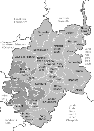
| Towns | Municipalities | |
|---|---|---|
References
External links
Wikiwand in your browser!
Seamless Wikipedia browsing. On steroids.
Every time you click a link to Wikipedia, Wiktionary or Wikiquote in your browser's search results, it will show the modern Wikiwand interface.
Wikiwand extension is a five stars, simple, with minimum permission required to keep your browsing private, safe and transparent.