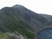
Mynydd Drws-y-Coed is a peak on the Nantlle Ridge in Snowdonia, north Wales. It is located at the easterly end of the ridge, and is a subsidiary summit of Trum y Ddysgl. It has steep west-facing cliffs, the summit area being the highest point on a thin ridge.[1]
| Mynydd Drws-y-Coed | |
|---|---|
 Mynydd Drws-y-Coed from Trum y Ddysgl | |
| Highest point | |
| Elevation | 695 m (2,280 ft) |
| Prominence | 57 m (187 ft) |
| Listing | Hewitt, Nuttall |
| Naming | |
| Language of name | Welsh |
| Geography | |
| Location | Gwynedd, Wales |
| Parent range | Moel Hebog |
| Topo map | OS Landranger 115, OS Outdoor Leisure 17 |
| Climbing | |
| Easiest route | Walk, Scramble |
| Name | Grid ref | Height | Status |
|---|---|---|---|
| Y Garn | SH551525 | 633 metres (2,077 ft) | sub Hewitt, Nuttall |
The west side is very rocky and airy, and some scrambling is needed to attain the summit. A good head for heights will also be needed on the exposed regions.[2]
References
Wikiwand in your browser!
Seamless Wikipedia browsing. On steroids.
Every time you click a link to Wikipedia, Wiktionary or Wikiquote in your browser's search results, it will show the modern Wikiwand interface.
Wikiwand extension is a five stars, simple, with minimum permission required to keep your browsing private, safe and transparent.