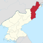
Mantapsan (or Mount Mant'ap, Chosŏn'gŭl: 만탑산) is a mountain in the south of North Hamgyong Province in North Korea.[1] The granite peak,[2] which reaches an elevation of 2,205 m (7,234 ft), is part of the Hamgyong Mountains. It is located on the border between Kilju County, Myŏnggan County and Orang County.
| Mantapsan | |
|---|---|
 Mantapsan Location of Mantapsan in North Korea | |
| Highest point | |
| Elevation | 2,205 m (7,234 ft) |
| Coordinates | 41°17′55″N 129°04′54″E |
| Geography | |
| Location | Kilju County, North Hamgyong Province, North Korea |
| Parent range | Hamgyong Mountains |
| Korean name | |
| Chosŏn'gŭl | 만탑산 |
|---|---|
| Hancha | |
| Revised Romanization | Mantapsan |
| McCune–Reischauer | Mant'apsan |
Political prisoners were reportedly forced to dig tunnels into the southern side of the mountain, at the nuclear test site near P'unggye-ri.[3] The horizontal tunnels are believed to be two to three meters wide and high and hundreds of meters long.[4] This is where the detonations of the North Korean nuclear tests in 2006, 2009, 2013 and 2016 occurred.[5]
International analysts believe that the sixth and largest explosion, as of January 2024 the last, "made the mountain bulge sideways by about 12 feet and collapse vertically by about a foot and a half", with one seismologist describing the subsequent reaction as the mountain "pancaking".[6]
Hwasong concentration camp, at 549 km2 (212 sq mi) the largest North Korean concentration camp,[7] is located between Mantapsan and Myŏnggan (Hwasŏng).