Loading AI tools
Comune in Friuli-Venezia Giulia, Italy From Wikipedia, the free encyclopedia
Monfalcone (Italian pronunciation: [moɱfalˈkoːne]; Bisiacco: Mofalcòn; Friulian: Monfalcon; Slovene: Tržič; archaic German: Falkenberg) is a town and comune (municipality) in the Regional decentralization entity of Gorizia in Friuli-Venezia Giulia, northern Italy, located on the Gulf of Trieste. Its name means 'falcon mountain' (see Montfaucon in French and Falkenberg in Germanic languages).
Monfalcone | |
|---|---|
| Comune di Monfalcone | |
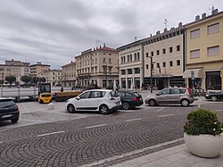
 Piazza della Repubblica in Monfalcone | |
| Coordinates: 45°48′N 13°32′E | |
| Country | Italy |
| Region | Friuli-Venezia Giulia |
| Province | Gorizia (GO) |
| Frazioni | Archi, Aris, Bagni, Cima di Pietrarossa, Crosera, La Rocca, Lisert, Marina Julia, Marina Nova, Panzano, Pietrarossa, San Polo, Schiavetti, Serraglio, Via Romana-Solvay |
| Government | |
| • Mayor | Anna Maria Cisint |
| Area | |
| • Total | 20 km2 (8 sq mi) |
| Elevation | 7 m (23 ft) |
| Population (1 January 2022)[2] | |
| • Total | 29,637 |
| • Density | 1,500/km2 (3,800/sq mi) |
| Demonym | Monfalconesi |
| Time zone | UTC+1 (CET) |
| • Summer (DST) | UTC+2 (CEST) |
| Postal code | 34074 |
| Dialing code | 0481 |
| ISTAT code | 031012 |
| Patron saint | St. Ambrose |
| Saint day | November 21 |
| Website | Official website |
It is a major industrial centre for manufacturing ships, airplanes, textiles, chemicals, and refined oil, and the home of the Fincantieri cruise ship building company. Monfalcone is the northernmost city on the Mediterranean Sea.

Monfalcone is the fifth most populous town in Friuli-Venezia Giulia and the main centre of Bisiacaria territory. Joined to its neighbourhoods, it has about 50,000 inhabitants. The town lies between the Karst hills and the Adriatic coast, and it is the northernmost port of the Mediterranean Sea.
In prehistoric times the area of Monfalcone housed several fortified villages called castellieri. After the foundation of the Roman city of Aquileia (181 BC), some thermal buildings were created on the hills, known as Insulae Clarae.
After Ostrogoth, Byzantine, Lombard, and Frankish domination, Monfalcone was controlled by the Patriarchs of Aquileia starting from 967.[3] The Venetians conquered it in 1420 after three days of siege, keeping it until 1511, when it fell to the French. Conquered back by Venice, it was ravaged by the troops of Habsburg Emperor Maximilian I in 1513, who destroyed the Rocca fortress. In 1521 it was returned to the Republic of Venice, under which it remained until its dissolution by the 1797 Treaty of Campo Formio.

From 1805 it was controlled by the French Empire until the fall of Napoleon in 1814, after which it was included in the Kingdom of Illyria, part of the Austrian Empire. Incorporated into the crown land of Gorizia and Gradisca, it belonged to the Austrian Littoral from 1849. The first shipyards arose from about 1908 onwards, among them the Cantiere Navale Triestino company building steamships for the Austro-Americana Line based in Trieste. During World War I, the town was captured by Italian forces in 1915 and became the rear line during the bloody Battles of the Isonzo, being briefly recaptured by Austria-Hungary after the 1917 Battle of Caporetto, but returning to Italy in 1918. The shipyards were severely damaged by bitter fighting and had to be rebuilt afterwards. During World War II the town was repeatedly bombed and heavily damaged, became a center of the Italian Resistance after the Armistice of Cassibile, and it was briefly occupied by Yugoslav troops at the end of the war.
Monfalcone railway station, opened in 1860, is a junction between the Venice–Trieste railway and the Udine–Trieste railway.
The construction and design records of the ships produced in Monfalcone Shipyard Number 1 from 1909 - 1967 have been preserved in the Fondo Egone Missio Archives (Egone Missio Archives).
Monfalcone is twinned with:
| Climate data for Monfalcone (Ronchi dei Legionari) (1991–2020) | |||||||||||||
|---|---|---|---|---|---|---|---|---|---|---|---|---|---|
| Month | Jan | Feb | Mar | Apr | May | Jun | Jul | Aug | Sep | Oct | Nov | Dec | Year |
| Mean daily maximum °C (°F) | 8.9 (48.0) |
10.5 (50.9) |
14.5 (58.1) |
18.5 (65.3) |
23.1 (73.6) |
27.2 (81.0) |
29.6 (85.3) |
29.7 (85.5) |
24.6 (76.3) |
19.4 (66.9) |
14.0 (57.2) |
9.8 (49.6) |
19.2 (66.5) |
| Daily mean °C (°F) | 4.1 (39.4) |
5.0 (41.0) |
8.7 (47.7) |
12.6 (54.7) |
17.3 (63.1) |
21.2 (70.2) |
23.4 (74.1) |
23.4 (74.1) |
18.8 (65.8) |
14.1 (57.4) |
9.3 (48.7) |
5.0 (41.0) |
13.6 (56.4) |
| Mean daily minimum °C (°F) | −0.6 (30.9) |
−0.4 (31.3) |
2.8 (37.0) |
6.8 (44.2) |
11.4 (52.5) |
15.2 (59.4) |
17.2 (63.0) |
17.1 (62.8) |
13.0 (55.4) |
8.7 (47.7) |
4.5 (40.1) |
0.2 (32.4) |
8.0 (46.4) |
| Average precipitation mm (inches) | 69.6 (2.74) |
69.4 (2.73) |
77.1 (3.04) |
124.8 (4.91) |
139.5 (5.49) |
108.6 (4.28) |
93.4 (3.68) |
102.7 (4.04) |
111.6 (4.39) |
168.4 (6.63) |
170.5 (6.71) |
92.8 (3.65) |
1,328.4 (52.29) |
| Source: Istituto Superiore per la Protezione e la Ricerca Ambientale[5] | |||||||||||||
In 2024 religious, cultural and ethnic factors gained importance with cricket being banned in the town.[6]
Seamless Wikipedia browsing. On steroids.
Every time you click a link to Wikipedia, Wiktionary or Wikiquote in your browser's search results, it will show the modern Wikiwand interface.
Wikiwand extension is a five stars, simple, with minimum permission required to keep your browsing private, safe and transparent.